Northern California

Humboldt County, California
Alderpoint Rd
47 Miles - Length
Humboldt - COUNTY
Two-lane, poor, patched, short gravel sections - PAVEMENT
Hairpins, slow, bumpy, super-curvy - CURVES
Garberville, Alderpoint, Dinsmore - GAS

Quick Ride: Remote backroad in the heart of the Emerald Triangle
Promise me.
HIGHLIGHTS
Bell Springs Rd
Alderpoint
Redwood Trail
Zenia Bluff
My Pashnit Motorcycle Tour group made a steady pace headed down Alderpoint Rd. We were riding south, using Alderpoint Rd as a shortcut from Highway 36 to Garberville and then riding out to Shelter Cove as our lodging for the night. After an hour of navigating the twisty curves to a planned stop, one of the riders, we'll call him Phil, ran up to me.
Phil approached me and said, “You have to promise me, we will never, ever, ride this road again.”
Now, Phil is a good friend, and we ride together a lot. I have led him over many miles of exploration, tens of thousands. But for this ride, he showed up for the tour on a beautiful carbon fiber encrusted Aprilia RSV that he normally uses on the track. A bit of luggage, and you've got a touring bike. Right? Not so fast.


Southern entrance to Alderpoint Rd at Garberville
Alderpoint Rd on the map looks like the perfect solution. It's a shortcut from Bridgeville to Garberville and cuts 71 miles down to 47 miles, a fair amount of less mileage if you don't have to loop all the way west over to Fortuna and then south on Hwy 101 to reach Garberville. And to make things more interesting on the southern leg of Alderpoint Rd, it's amazingly scenic. The road cuts into the sides of mountainous fingers that run north-south through mountainous terrain across treeless green meadows that offer up expansive views of the surrounding mountains.
Deep in the valley below Alderpoint Rd is the mighty Eel River draining a massive wilderness watershed of 3,684 square miles, a region the size of Hawaii, or about 2.5M acres, then flowing out to the ocean past Ferndale. It is the third-largest watershed in California.The Eel River is home to the Pacific Lamprey, a parasitic fish that looks a lot like an eel - giving the Eel River its name.
We begin our ride in Garberville along Highway 101. Garberville is a tiny way stop along Highway 101, The short main street is the entire town, good for gas, lodging, and a quick bite to eat. Garberville is also known as the center of the Emerald Triangle, better known as the marijuana industry made legal a few years ago. An industry that operated in the shadows now is attempting to transition to being perfectly normal. Garberville, a town of about 1000, even has a Cannabis College and the BBC phrased Garberville as the marijuana heartland of the United States.

Alderpoint leaves Garberville on the north end of town in a steep uphill climb, gaining elevation rapidly. The road is a wide two lanes, endlessly twisty, and climbs through numerous hairpins to gain access to the ridge top. The surface of the road despite the centerline is bumpy, patched, and sometimes potholed. To make things a bit more interesting, the southern section of Alderpoint Rd to the small town of Alderpoint is an endless series of heaves and perpetual movement in the ground below. At certain points, we’ve encountered massive half-moon slices of the road beginning to slide into the canyon below. This creates a small drop-off and then another as you ride in and out of the half-moon-shaped depression.

One year, we rode over a 4-inch lip, next year it was all repaired and a memory. Adjust your speed to ride around these if you can. Another year, we encountered a similar scenario 13 miles south from Highway 36, the road had slid into the canyon below and the hole had been filled in with gravel. Anticipate gravel stretches somewhere along this stretch of road to Highway 36, hopefully, it will be marked with a ‘Loose Gravel’ sign. It won’t say ‘Pavement Ends’ which seems more appropriate. The southern leg can be busy with vehicles, especially pickups. You begin to realize that although the town of Garberville is quite small, this traffic is not townspeople but rather locals spread out in the hills and constantly flowing in and out of town.
Bell Springs Rd
Outside Garberville, 8 miles, at the top of the ridgeline is Bell Springs Rd. I got the harebrained idea one day to ride this on my Yamaha FJ1200. I had no idea if it was paved or not, only that it wasn't the 101 freeway, and it ran parallel to 101. Seemed like a good idea at the time. It quickly went to dirt, and I was too stubborn to turn back, it was one of those 'wonder where this goes sort of days'. The pavement lasted past the New Harris General Store for 8 miles and ended at the Island Mountain Rd junction. The southern leg of Bell Springs Rd is 19-miles of gravel ranch road, but does pop out on the 101 Freeway after 27 miles from Alderpoint Rd near the Tan Oak Rest Area.

Bell Springs Rd on the FJ1200

What we love about NorCal are the pickups. Big pickups, small pickups, ratty pickups full of mud, jacked uplifted trucks with huge pipes sticking straight up out of the bed belching fire and brimstone, turbines emitting a delicious high pitch whine. Be mindful of the pickups in these hairpins and stick to your side of the road. It’s their road and they travel it daily. There are numerous side roads, driveways, and offshoots to adjacent ranch homes stuck back in the forest and hillsides. I always expect this road to be deserted, but it never is. It feels like a backroad, but to the locals, it’s the only road.
There are gorgeous views to the south as you ride this leg to Alderpoint popping in and out of the trees. In springtime, these hills are brilliant with green grass. Also take note of cows, as portions of Alderpoint Rd are open range, and cattle roam freely, even on the road.

Alderpoint
The road narrows as you reach Alderpoint. Named for alder trees that were prolific in the area, Alderpoint was built on an 180-degree bend in the river that encircles the town. The town functioned as the base for the construction crews building the Northwestern Pacific Railroad along the Eel River in 1910. Once the railway was completed in the late 1910s, steam trains would leave Arcata, use Fort Seward as their lunch stop, then pick up cars full of lumber from the lumber mill at Alderpoint.
The entire town of Alderpoint is about 5 streets, although there is a fuel station at the Alderpoint General Store on Alden Street with above ground tanks, but I have never attempted to buy fuel here.

Free range cattle are the norm along Alderpoint Rd

Screenshot from Google Street View in spring, expansive wide open views are the norm in the southern section
There is no sign for the General Store anywhere along Alderpoint Rd, and to make things more interesting, the street sign says this is Craig Street and the General Store lists their address as 418 4th St. Confused yet? Me too. But with 5 streets, are addresses even important? Probably not. Find the post office in the center of town, the general store is next door. The Alderpoint General Store states they offer a deli, cold drinks, hot foods, unleaded and diesel fuel, groceries, and garden supplies. While most roads run through the center of town, Alderpoint Rd does the opposite and skirts along the edge of the town, essentially bypassing it. If you want to stop here, you’ll need to make a point to pull off into this tiny town, presumably to the general store.
If Alderpoint Road was carved out in 1910 to help build the railroad, that explains its many twists and turns, which are endless. This road pre-dates automobiles and was designed for horse and buggy. The views though warm the soul, with plenty of places to pull over for a few moments. The road is still two lanes, but the occasional patching will keep speeds moderate, this is not a road to go fast on. Oh, and if the name Alderpoint seems familiar, it’s because the town was the centerpiece of the Murder Mountain documentary on Netflix.
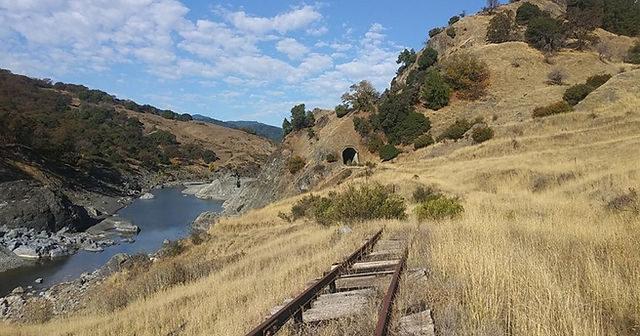
Plans are in place to repurpose 300 miles of Northwestern Pacific Railroad bed into a hiking / biking trail
The railway along the Eel River originally ran from the Bay Area, running 271 miles from Schellville in Sonoma County (present-day junction of Highway 12 & 121) to Eureka. Current trains only run as far north as Windsor, and the Eel River section has been abandoned for many years. The railway was most active in the 1970s until trucking companies began to out-compete the railway as improvements to Highway 101 were completed, and rail traffic began to decline. Although trains ran up the Eel River as recently as the late-1990s, storms in the region washed out tracks and weakened rail bridges. Eventually, lack of capital and decreased profits shuttered operation on the Northwestern Pacific Railroad, and the tracks have been abandoned ever since.
Great Redwood Trail
Ideas have been floated to repurpose the Northwestern Pacific Railroad tracks from Sonoma County as far north as Eureka and Arcata, but the only idea that has gained traction is re-purposing the railroad bed as a Rail Trail. The idea being to convert the disused railway track and re-purpose it for hiking, biking, horses, and even snowmobiles. The Great Redwood Trail would stretch nearly 300 miles between the San Francisco Bay Area to Humboldt County. The idea of a 300-mile-long biking trail into Northern California has excited many people. If completed, the Great Redwood Trail would be the longest rail-trail in California, and one of the longest in the United States. It would provide access to some of the most beautiful and remote landscapes of Northern California.
Along the route, users would find 13 train trestles, 32 bridges, and 36 tunnels, the longest of which is, 4313 feet long.
Planners anticipate 1.2 million annual users if the trail is ever built. The trail would pass directly under Alderpoint Rd at the Eel River bridge before continuing to the Avenue of the Giants, Scotia and further north into Humboldt County.
The tiny town of Alderpoint would likely benefit greatly if the Great Redwood Trail ever were built as the town site lies centered on a broad bend in the Eel River with the railway bed/future trail encircling the town.

The Great Redwood Hiking Trail would connect San Francisco with Northern California
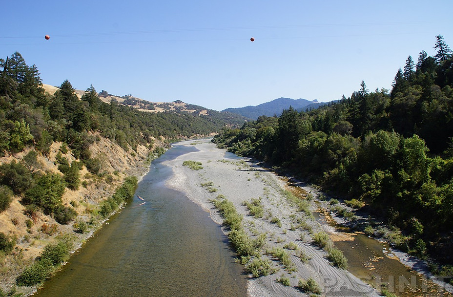
Eel River Bridge, the Northwestern Railroad bed is on the right, overgrown with trees

Pashnit Motorcycle Tour group on the Eel River Bridge
Northbound riders, make the turn at the bridge over the Eel River. If you miss the turn, River Rd continues as a dead-end for a short distance to the long-forgotten sawmill. Many of these mills closed in the early 1990s, and the money that flowed into the local community from the timber industry dried up. The people remain though with many homes tucked away deep in these hills, some fairly nice, others surrounded in refuse, garbage, husks of cars, and household goods strewn about.
Alderpoint Rd leaves the Eel River behind and climbs up the hill out of the Eel River valley through several tight corners (some blind) before popping out of the trees again into the meadows and climbing in elevation for 1.5 miles to reach Hoaglin Rd.
At the top of the ridgeline is a large Y intersection. No signs for anything, bring a map or do your homework in advance if your destination is Zenia and beyond.
Hoagland Rd is the eastbound access point to Zenia, Kettenpom, Ruth, Mina and Ruth Lake. However, if the destination is Zenia, Hoagland Rd only lasts four turns, less than a mile, when Zenia Bluff Rd splits and continues northeast to Ruth and Highway 36.
Zenia Bluff Rd heads up to the one-horse town of Zenia, two buildings make up the entire town. This is paved (mostly) over to Ruth Lake.

Y-Intersection with Hoagland Rd. Hoagland goes right and connects with Zenia to Ruth Lake
There are no road signs at the (second) Y on Hoagland Rd. I guessed it was the right road, and Zenia Bluff Rd went to single-lane gravel almost right away (pavement resumed a hundred yards later). Then, I wondered if I was on the right road my first time through. Zenia Bluff Rd / Van Duzen Rd is a remote backroad no one has ever heard of. Click the link to learn more about riding to Ruth Lake and back to Highway 36. Not for everybody, but it is paved.

Zenia Bluff Rd is single-lane paved to Zenia
If you miss the turn-off for Zenia Bluff Rd one mile from Alderpoint Rd found in a hairpin, Hoagland Rd changes names to Peak Rd. This road is paved to Kettenpom, another remote mountain community on the edge of the Six Rivers National Forest. Kettenpom back to Zenia is 4 miles, all paved, but twisty mountain single lane, to form a loop. Kettenpom southbound is paved all the way to Mina and the rest of the 20-mile distance south to Covelo is dirt fire road.
Six Rivers National Forest is a vast wilderness region spanning over 1 million acres, larger than the state of Rhode Island, including over 137,000 acres of old growth forest and was established in 1947. The forest is named after the Eel, Van Duzen, Klamath, Trinity, Mad, and Smith rivers, which filter through or near the national forest's boundaries. The Six Rivers National Forest has 366 miles of mountain rivers and tributaries. There are few paved roads through this wilderness region, there are however many dirt fire roads that spider through the region southeast of Kettenpom.
This unmarked Y-intersection along Alderpoint Rd is the western access point into that wilderness. Six Rivers National Forest is a band of forest land that extends north through Highway 36, Forest Rd 1, Highway 299, and Highway 96 approaching the Oregon border.

Zenia Bluff Rd to Zenia included short sections of gravel.
Six Rivers National Forest is also the home of Bigfoot. The famous Patterson-Gimlin film taken in 1967 near Orleans along Highway 96. Be sure and check out the Bigfoot Museum in Willow Creek at the junction of Highway 299 and Highway 96.
North of Garberville 24 miles and 7 miles beyond Alderpoint, Fort Seward Rd descends to the Eel River. This road is single lane paved, but technically doesn’t connect to any paved road. It stays paved to the Dyerville Loop, but the majority of the Dyerville Loop is not paved. The Dyerville Loop however begins in the Avenue of the Giants (north end) and ends at Alderpoint Rd (south end) at Alderpoint Rd near Garberville.
Fort Seward as the name implies was a fort built in 1862 garrisoned by the US Army to provide security for settlers from the Native American population. Fort Seward later became a train stop for the Northwestern Pacific Railroad route along the Eel River.

Blocksburg
Blocksburg arrives at a hilltop as a small collection of fading homes, a post office operated here starting in 1877, today a tiny building takes on that role as the town post office. Blocksburg was once a stagecoach stop on the overland route from Eureka to San Francisco. At its height, it had several hotels, saloons, and a racetrack. The town’s namesake, Ben Blocksburger arrived in October 1872 with a wagon train of goods, half of which was whiskey. A town site was surveyed and lots sold for $100 apiece. A store, one hotel, the requisite blacksmith shop, a schoolhouse and various dwellings were erected. A road was constructed to Hydesville (at the west end of Highway 36) by Chinese laborers using pick and shovels, allowing farmers and ranchers into the area. A small store was opened here, but it was said to carry only the necessities, such as tobacco and whiskey.
During the town’s heyday, there were three hotels, three livery stables, five saloons, a millinery shop, drug store, two blacksmiths, a meat market and a jail. The town even boasted a photographer, a doctor, and a dentist. The racetrack claimed patrons from as far away as Los Angeles. Winters could be hard, and the winter of 1889 was especially harsh, killing off crops and even livestock. Ranchers in turn headed for more promising grounds. Fires in town also wiped out some buildings. By 1920, the stagecoach was replaced by automobiles along with Highway 101 through the present-day Avenue of the Giants.
Alderpoint Rd near Blocksburg
The logging industry stayed active through the 1940s and 1950s, but made a steady decline until it ground to a halt in the late 1990s. A vast majority of the forest is still owned by logging companies. Blocksburg today is three blinks, and we’re continuing our trek north.
Alderpoint narrows to single lane paved in some stretches, but the vast majority is two lane broken yellow line. Endlessly twisty, some portions are smooth and speeds edge up, then the patching starts and the speed declines to a more manageable pace. The northern leg of Alderpoint joins up with Larabee Creek. Henry P. Larrabee was a rancher and 49er who was active in Humboldt County, 1859-1862. He owned land around Blocksburg and the aforementioned town was even called Larabee in its early days. Larrabee Creek, Little Larrabee Creek, and Larrabee Valley in this area are all named for him.

Alderpoint Rd near Blocksburg

Alderpoint Rd runs parallel to the Eel River with many feeder creeks and streams draining into it

At the Bridgeville Quarry, Alderpoint Rd comes to an end at Highway 36. Bridgeville sits on the edge of the Van Duzen River, along with two bridges, the tiny town made itself famous when the 83-acre town site was put up for sale on eBay in 2002 for $1.77M and sold for $450,000 in 2004. Then put back on the market in 2006 and selling for $788,500, the buyer then put the town back on the market in 2015 at $955,000 and included three cows, eight houses, and the post office. The next owner paid $1.25M, but after his untimely death, the town went back on the market in 2007 for $1.3M, the third time in 5 years the town would be listed for sale. At the time of this writing, the town is currently on the market at $1.5M and has been on the market for the last five years. Still includes the 8 houses and 40 residents, not sure on the cows.
At Bridgeville, Dinsmore (gas) is 15 miles to the east, and you can reach Highway 101 to the west 24 miles away through the redwoods to continue your trek south towards Garberville. The closest gas to the west would be Hydesville 20 miles away. Bridgeville is where Alderpoint Rd starts and ends.
Closing Thoughts
Overall, Alderpoint Rd is not a shortcut, it’s likely longer time-wise than the 71-mile trek to Garberville from Bridgeville due to the reduced speeds and required breaks. Plus, build in the need to be constantly at the ready for gravel patches, bumpy patches, and tight blind corners. While Alderpoint Rd often invites speed, and the majority of it has a center line, the bolder you get, the bigger the slap in the face. My ride buddy Phil made me promise never to lead a motorcycle tour with him on it down this road. I’ve kept that promise, but not before we chided him that although deliciously stunning, carbon fiber encrusted Aprilia RSV’s are the wrong bike for this road. I've ridden it on my Hayabusa(s), my TL1000R, my Z1000 and a borrowed GS with knobbies. Your experience may be influenced by the amount of suspension travel you bring to the party.

Opinions will vary on whether it’s a good idea is to use Alderpoint Rd as a shortcut and bypass a long boring stretch of the Hwy 101 freeway. Phil was on the wrong bike, that was rather obvious. Those with more supple suspension travel may wonder what all the hubbub is about. But in the end, it’s like most things in life, you need to decide for yourself if a road like this will interest you.
Where to Next?
Which way are you headed, north or south? Since this ride description is riding north, lets cover that first. Highway 36 doesn’t need much introduction. We love this road and it loves motorcycles. The 5-mile one-lane section has been sadly removed and replaced with a real highway as of late 2021. Headed north, hook up with Forest Rd 1 via Lamb Creek Grade to Willow Creek and Highway 299. Nearby is Highway 3 Hayfork Pass into Weaverville or ride due east all the way to Red Bluff and head for Lassen Volcanic National Park. Note Kneeland Rd (continuation of Alderpoint Rd headed north is not paved. Pavement starts back at the Kneeland Airport into Eureka.
Southbound on Alderpoint offers Zenia Bluff - Van Duzen Rd as a remote backroad loop. Note both Van Duzen Rd, and the 101 Freeway run parallel to Alderpoint Rd. This road is not for everybody, but there are riders that love these remote backroads. Bell Springs Rd (south end) is also not paved. At Garberville, you’ll be on the south end of Avenue of the Giants, fuel up and make for Shelter Cove. Or head for the Highway 1 Leggett section, likely the twistiest road in the state of California


Alderpoint Rd starts or ends along Highway 36. The redwood forest is nearby.
Alderpoint Road - Bonus Photo Gallery


MORE INFO: Alderpoint Rd
RIDE IT on a PASHNIT TOUR
47 Miles - LENGTH
Fair, bumpy, patched, gravel patches - PAVEMENT
Extreme, tight, hairpins, elevation change - CURVES
Garberville, Dinsmore, maybe Alderpoint - GAS
Benbow, Garberville, Fortuna - LODGING
2800 ft - PEAK ELEVATION
GPS LOCATION
40°6′N 123°48′W - Garberville
40°10′35″N 123°36′42″W - Alderpoint
40°28′10″N 123°47′59″W - Bridgeville
LISTED CONNECTING SIDEROADS:
Dyersville Loop (dirt)
Bell Springs Rd
Hoagland Rd / Zenia Bluff Rd
Fort Seward Rd
Kneeland Rd (dirt)
Additional RESOURCES
Bridgeville Zillow Sale Listing
Highway 36 Road Conditions


