Northern California

Lassen County, California
Highway 89 Mount Lassen
34 Miles - Length
Shasta- COUNTY
Very good, closed winter - PAVEMENT
Enthusiast, super-curvy - CURVES
North end near entrance - GAS

Quick Ride: Enjoyable motorcycle ride over Lassen Peak, Gateway to the Southern Cascade Range.
The Joy of Motorcycling
HIGHLIGHTS
Southern Cascades
Visitor Center
1915 Eruption
Sulphur Works
Butterflies
Dark Sky Festival
Recently, a cohort of mine re-launched a web site known as the 'Joy of Motorcycling', her first name is Joy so that offers a double entendre one can savor. The concept of this site (which is about training riders to be better riders) got me thinking- about Joy, and about motorcycling. My wandering brain thought, where can I go to experience those two ideas in the same breath? My brain immediately spit out Lassen. You go to Lassen & ride Highway 89.
And as I began to absorb the author’s motivation for wanting to spread her message, I became even more intrigued by her battle with a traumatic brain injury she experiences from a seemingly minor motorcycle accident. Obviously, I identify with this storyline since I broke the inside of my brain while riding my own motorcycle a few years back.
Her description of her healing process to create new pathways inside the brain around the damaged tissue is relatable. While my own experience was mild in relation to what Joy describes, the takeaway is the same. The desire to get back to center, back to normality, whatever that is. In Joy’s case, back to the Joy of Motorcycling.


You can do that as you ride Highway 89 through Mt Lassen Volcanic National Park.
The 34-mile ride through Lassen NP is a short segment in a much longer motorcycle road. Highway 89 extends 360 miles north to south; the southernmost leg is better known as Monitor Pass which you can read about here.
We’ll cover the rest of Highway 89 along Lake Tahoe, through Quincy, and over to Weed at a later date, but for now, let’s ride it over Mount Lassen.
Snowfall during 2023 at Mount Lassen
The Southern Cascades
Mt Lassen is a semi-dormant volcano in Northern California demarcating the northern end of the Sierra Nevada Range we love to play in so much. The Cascade Range begins here extending due north across the Canadian border and comprises a leg in the Ring of Fire, a 25,000-mile horseshoe shape of volcanic activity. More than 75% of the world’s active and dormant volcanoes are located in this ring that largely encircles the perimeter of the Pacific Ocean.

The Cascades are well-known for tall cinder cone mountains like Mt Rainer, Mt Baker, Mt Shasta and our ride for today, Mt Lassen. The location of the Cascade Range bordering the western United States along the Pacific Ocean provides for ample moisture in the form of snow on western slopes. Snowfall in the Cascade Range can reach 1000 inches per year – yes, 83 feet of snow over winter months. In our locale, Lake Helen near the summit has received over 40 feet of snow in some seasons. Which is why my tour groups have ridden Lassen in mid-July and played in snow. And why the pass is not likely to be open in late May for the Memorial Day weekend although when you ride the southern entrance, Highway 89 is typically plowed to the visitor center or the next parking lot to view the boiling mud pot at Sulphur Works Parking.

Kohm Yah-mah-nee Visitor Center - in June.
With a relatively low summit of 8514 ft, Highway 89 over Lassen still gets an immense amount of snow that can easily stretch into mid-year depending on the season.
The pass over the summit isn’t open till mid-June and I have made the mistake thinking I could get over the pass on Memorial Day weekend during the last weekend of May and had to run a wide detour though Manton to get to the other side.
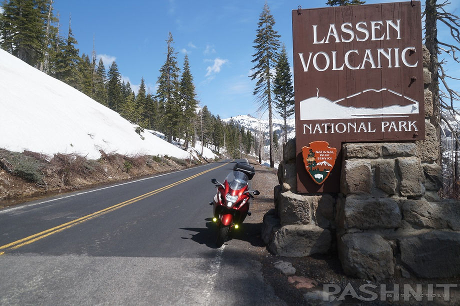
The entrance at the south end of Lassen is along Highway 36 in-between Red Bluff to the west and Chester/Lake Almanor to the east. The north entrance is found along Highway 44. There are few opportunities to fuel up along this ride so plan out your range accordingly.
The ride up and over the mountain to Highway 44 stretches out 35 miles. There is 24-hour fuel on the north end of the park at Manzanita Lake Camper Store and gas station mid-May through mid-October. Head north on Highway 89 from Highway 36 near Mineral. What you can’t see from the road is barely perceptible as a steady northern climb towards the park entrance and Visitor Center 10 miles distant up a ridgeline to the west of Mill Creek. Mill Creek below the ridge provides the southern watershed for much of Lassen eventually flowing downstream to Tehama where it joins the Sacramento River into the Central Valley and eventually draining out of San Francisco Bay into the Pacific Ocean.
Two miles from Highway 36 is a wide pullout on the west side of the road for the McGowan Cross-Country Ski Area - North Trailhead. Forest Rd 29N22 is here. Strap on the skis and head down this forest road which eventually connects back to Mineral. The park entrance is 5 miles north of Highway 36.
Kohm Yah-mah-nee
Visitor Center
After paying your entrance fee, pull into the parking area for the Kohm Yah-mah-nee Visitor Center. It receives its name from the Mountain Maidu name for Lassen Peak which means “Snow Mountain.” This building was renovated in 2008 and the interior resembles a small museum, with multiple interpretive displays of area history and geologic presentation of the volcanism beneath your feet. Even in winter, Highway 89 is typically plowed to the south visitor center. Out behind the center is a broad patio with an expansive view of the mountain worthy of a national park. Feel free to burst into song in your best Julie Andrews rendition of The Hills are Alive. The view from the backside of the visitor center features Mt. Diller to the left, and Pilot Pinnacle on the right. On cool days, it's possible to see the steam rising from the Sulphur Works hydrothermal area which is the next stop after leaving the visitor center.


The visitor center is also the parking lot for the Southwest Walk-In Campground which is self-serve, or rather first-come-first-served along West Sulphur Creek. Restrooms are open 24-hrs to serve the campers at the visitor center.
What you can’t see from the visitor center is Mount Lassen which dominates the scene with its size.
This region around Mount Lassen is actually a grouping of 30 volcanic peaks across a large square area. Mount Lassen is considered the largest lava dome on earth and is the largest of the 30 peaks said to have formed 27,000 years ago.
Lassen Peak produced a dramatic eruption in 1915 visible for many miles as Mount Lassen can easily be seen from the Central Valley and even from Bay Area peaks like Mount Diablo & Mount Um on a clear day.

1914 Mount Lassen Eruption
The 1915 eruption spread ash as far as 200 miles to the east. It was the last eruption to occur in the Cascade Range until Mt. St. Helens in 1980. Large eruptions are said to occur at intervals of every 10,000 years, the last large eruption measured at 1100 years ago at Chaos Crags. Meet us back here in 9000 years.
Sulphur Works
One mile up the road is a parking area for Sulphur Works. As the name implies, this is an area where hot gases are emanating to the surface as steam and volcanic-gas vents, it smells like rotten eggs and a bubbling mud pot is right beside the road. The temperature of the water reads 175 degrees. The smell is from hydrogen sulfide gas that emits from steam vents known as fumaroles. Cooling magma beneath your feet is the source of the gas. Every time we have come here, the mud pot looks different. Sometimes boiling water, other visits it was more like hot pudding.


This vat of bubbling mud contains the perfect mix of ingredients to create mudpots: heat, gases, water, volcanic rock, minerals, acid and thermophiles – heat-loving microorganisms too small to be seen by the naked eye. These thermophiles consume some of the gases and help convert them into sulfuric acid. The acid breaks down rock to form clay, which mixes with water to create mudpots. Mudpots change with the seasons. In late summer when there is very little precipitation, mudpots are dry and dominated by steam. When the snow melts, water mixes with clay to form a bubbling cauldron of mud.
While this one is right beside the highway, the park actually has eight different hydrothermal areas to explore. Boiling Springs Lake is another easily assessable area in the Warner Valley region with a 1.8-mile round trip hike. Further up this trail is Terminal Geyser. The water in this lake sits at a toasty 125 degrees. Devils Kitchen is another area when steam vents release ample amount of steam and you can even hear the water boiling beneath your feet within the steam vents below the trail. Cold Boiling Lake, Pilot Pinnacle, Little Hot Springs Valley and Bumpass Hell are additional regions of the park to explore. Bumpass Hell is the largest at 16 acres but is only accessible via a 3-mile hike. Most of these areas require a short hike to reach but for the motorcyclist, the Sulphur Works area is ample taste of volcanism beneath our feet. Get your picture, take the selfie, post it, and let’s head up the hill.

California Tortoiseshell Butterflies
At an unpredictable interval, you may ride through swarms of California Tortoiseshell butterflies. The butterflies have occasional population explosions and migrate up and down the canyons of the park. In 2004, a swarm 40 to 50 miles long by 15 miles wide were noted to be traveling south along the Sierra Nevada Range. The butterflies experienced another mass explosion in their population in 2019. The swarm then scattered while returning in September to the Sierra and Cascade Foothills to hibernate for the winter. While the seasonal migration is a constant, the quantity of butterflies varies in dramatic numbers producing in some years clouds of butterflies that also may coat the ground while the butterflies rest to conserve energy during hot, dry summer months. The butterflies estivate, or enter a state of inactivity.

Lassen Dark Sky Festival
The Lassen Dark Sky Festival takes place each year, generally around late July to mid-August and attracts thousands of visitors as an all-day event. The highlight of course is numerous telescopes set up to allow the curious to gaze off into the night sky. Normally, a three-day event of stargazing and astronomy activities such as solar scope viewing constellation tours and most interestingly, many experts from NASA and other professional organizations attend. Lassen isn’t the only place the Dark Sky Festival takes place, other parks like Kings Canyon & Sequoia National Parks in Central California have their own version of this event each summer.

Bumpass Hell Parking Area
and Overlook
One mile from Sulphur Works is the Bumpass Hell Parking Area and Overlook. There’s a large ball-shaped rock here we’ve used from group photos numerous times through the years. Our riders keep attempting to push it off the mountain to no avail.
You can view the rim of the former 11500 ft Brokeoff Volcano, also known as Mount Tehama. This large parking areas is also the trailhead for the Bumpass Hell hike. Those of you with the squeaky riding boots (you know who you are), might want to bring the hiking shoes if you’re headed that direction.
Highway 89 flows through a photogenic set of s-curves (below) to reach the summit. If you are the photographer in your riding group, best set off before your buddies and get positioned to photograph the group headed up the hill.


Lake Helen at 8300 ft. is often still frozen in July

10,547 foot Mount Lassen viewed from Lake Helen
Lake Helen
The road circles around Lake Helen nearing the summit, this glacial lake at the 8200-foot level was named for Helen Tanner Brodt who became the first white woman to reach the summit of Lassen Peak in 1864. The lake is often frozen and covered in snow most of the year.
Annual snowfall around the lake is 600-700 inches per year making it the snowiest place in California. Average snow depth here is 14 feet and snow has been known to last all the way through the summer into August. Lassen can get snow any day of the year.
Lassen Peak Trailhead
At the summit is the Lassen Peak Parking Area and the road tops out at 8512 feet. Not the highest mountain pass if you’re used to wandering up and over the Sierra Nevada passes but still ample snow even into July. Park here to hike up to the top of Lassen Peak.
Kids often come for school field trips, both my two older kids during 5th grade came to the mountain and hiked to the top of 10,457-foot Lassen Peak with their 5th grade classmates.
One particular rainy visit here, my Pashnit Tour group elected to head back to the hotel to dry off while I rode solo up to the summit into the rain. As I reached the summit, the rain stopped for a moment.

I parked atop the summit completely alone and climbed up the sheer side of the road cut snow bank some 10 feet above the road. The sudden stillness then changed to snowing. Realizing my predicament, the snow began to fall in earnest until it began to create white out conditions at this 8500-foot level. My camera-self said get the photo, this is super cool! My rational-self said you have to get off this mountain top. Snow experts will tell you there are many different types of snow flakes, these were heavy flakes that floated out in front of me and clung to my gear and coated my visor in mere minutes. Rejoined with the motorcycle and comforted by that warm steady burble, the trick in any mountain top white-out is simply go down. Not too complicated. And I descended back into the rain within mere moments thankful for the electric vest that compensated for the 32-degree chilly rain. A few thousand feet lower, the rain stopped completely and it was dry out. As mentioned earlier, these mountains create their own weather.

Getting caught in a blizzard on the summit in late May
Northern Half
The 8500-foot summit squeezes through a mellow depression, Mt Helen to the south, Lassen Peak to the north and begins the descent to Highway 44. The north half of Mount Lassen is less aggressive and makes a steady and relaxed descent to Manzanita Lake along with several broad viewpoints across the range. Two sets of switchbacks drop the elevation along the slopes of 8714 ft Reading Peak. All the area peaks are hikeable for the squeaky boot guy in your group that was kind enough to bring other shoes. Reading Peak is a 3/4 mile hike to the summit and the road snakes around the base.

Pashnit Tour Group riders railin' through the delicious curves over Mount Lassen
These peaks are the volcanic remnants of the original caldera of ancient Mt. Tehama which you viewed back at the visitor center. Mount Tehama was a massive stratavolcano that predates Lassen Peak. Mount Tehama, or Brokeoff Volcano, was last active 590,000 to 387,000 years ago. The surrounding peaks of Brokeoff Mountain, Mount Conrad, and Mount Diller recreate the outline of Mount Tehama. This ancient mountain measured 11 miles across and reached a height of 11,500 feet, 1,000 feet taller than Lassen Peak. The mountain gradually eroded away into what we see today.

Summit Lake is another small body of water right alongside the highway. Surrounded in several camping areas, there is also a flat walking trail around the circumference of this shallow alpine lake at the 6700 foot level. Every campground in the park is located above 5650 feet. Highway 89 offers up one more hairpin at the Paradise Meadow Trailhead while the road bridges over the West Fork Hat Creek and continues the steady descent.
You can't be in a hurry on this road. Campers, weekenders and gawkers are distributed evenly throughout the park, and even worse is the person driving so slowly, they appear lost.
There is a large parking area for the Hiking Devastated Area Interpretive Trail. This ½ mile trail meanders through pink and gray lava rock and highlights the effects of volcanic eruptions. It’s a short trail so if you need to get off the bike, but don’t want to be wandering through the mountains in your squeaky boots, this is a good option to take a breather and enjoy the mountain air.

Paradise Meadow & West Fork Hat Creek

Loomis Museum
Highway 89 wraps up the 34-mile ride over Mount Lassen as you reach the northern entrance at Reflection & Manzanita Lake. The Discovery Center, Ranger Station and Loomis Museum are in this collection of buildings. Worth visiting is the historic Loomis Museum located at the northern entrance and only open during summer.
Estella and Benjamin Loomis built the Loomis Museum, seismograph building, and Loomis House in the Manzanita Lake Area in 1927.
Originally hotel owners in Viola, 7-miles west of the present-day park entrance, the Loomis' visited the Manzanita Lake area frequently eventually purchasing the surrounding land as a 40-acre tract of land and constructing a small home and the building that now houses the museum. The museum was dedicated to their deceased daughter who died in 1920 and included Benjamin's photographic collection.
Benjamin Loomis photographed the 1914-1917 series of eruptions and the photographs drew national acclaim prompting the call to turn the mountain into national park land. The Loomis' lived in the small home they built and sold film, cameras, pictures and postcards from the present-day museum. Estella died in 1953 and the small home and surrounding land was donated to the park service, which includes the present-day Loomis Ranger Station

Where to next?
Shingletown is 20 miles to the west, it’s tiny, but there is fuel and food here. Follow Highway 44 to Redding and continue on Highway 299 out to the Pacific Ocean and the Trinity Alps motorcycle playground.
The junction with Highway 44 headed south back to Chester is 15 miles to the east to make a loop.
Burney McArthur Falls is found 28 miles north up Highway 89. Burney & Fall River Mills are the only small towns of any significance to the northeast.
Take note of Cassel Fall River Mills Rd. This is the back way into Fall River Mills, but it's not flat boring straight like a lot of the roads in this region and has some fun curves and zero traffic.
The Cassel Sculpture Garden is another roadside oddity that shouldn’t be missed either if headed through this region. The sculpture garden is located at: 22244 Cassel Rd, Cassel, CA. Punch that into your GPS and go check out this roadside oddity.
Highway 89 Mount Lassen - Photo Gallery


MORE INFO: Highway 89 Mount Lassen
RIDE IT on a PASHNIT TOUR
29 Miles - LENGTH
Very good, well-maintained state highway - PAVEMENT
Hairpins, mountain, super-fun - CURVES
North end of park- GAS
Chester, Fall River Mills, lots of camping - LODGING
8515 ft - PEAK ELEVATION
GPS LOCATION
40°21′20″N 121°34′2″W - Mineral
40°29′16″N 121°30′18″W - Lassen Volcanic NP
41°0′21″N 121°26′27″W- Fall River Mills
LISTED CONNECTING SIDEROADS:
Mineral King Rd
Warner Valley Rd
Cassel Fall River Mills Rd
RESOURCES
NPS - Lassen Volcanic National Park


Topo Maps