Coast Range, California

Lake County, California
Highway 175
Lake, Mendocino- COUNTY
State Highway, well maintained - PAVEMENT
Numerous, hairpins, steep grades to 10% - CURVES
Middletown, Cobb, Lakeport, Hopland - GAS
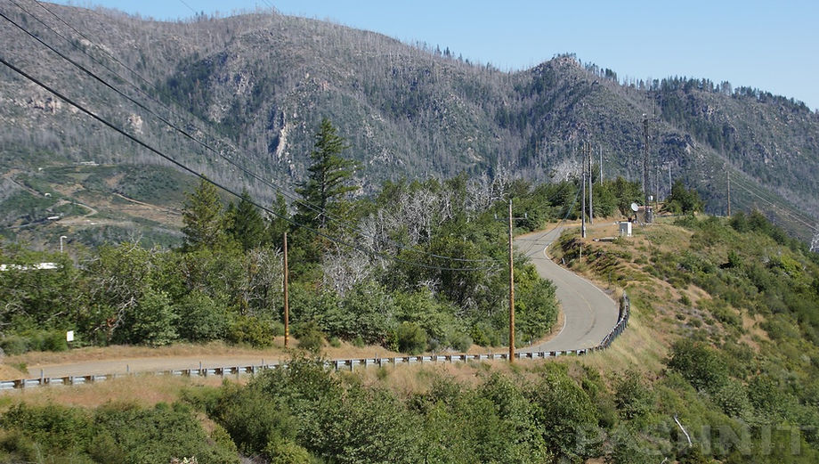
Riding Hopland Grade

Quick Ride: The Crookedest Road in California?
Twenty years ago, I rode with a guy we’ll call Jeff. He signed up for the third motorcycle tour I ever offered in the early 2000s. He was an expert rider, track day aficionado, and running solo around the state on a naked Aprilia Tuono, a streetfighter style bike that could barely cover 100 miles before the low fuel light came on. His first Pashnit Motorcycle Tour was 3 days of riding in the mountains of Northern California. We immediately hit it off, as I was newly married while he was dating a real-life ballerina. This fella on the Tuono had super smooth lines and rode in a manner I had never seen before; he would lay the bike into turns, drop a knee onto the ground and smoothly arc out of the turn. His riding style made it look effortless. I couldn’t keep up with him, didn’t even try, and it wasn’t until we switched bikes that I had the epiphany as to why he was so fast in the twisty bits.
The Aprilia Tuono is a naked standard with a 1000cc motor, zero fairings, wide handlebars, and bolt upright seating. While sitting on the bike, you were staring at the front tire. The bike was a stripped-down machine, a motor and two wheels, but at 123 hp and only 448 lbs. dry, it was a blast to ride. The front wheel came off the ground with ease upon every twist of the wrist. The Tuono cornered sure and steady like it was on rails. The sensation of riding that style of motorcycle made such a lasting impression on me, I eventually bought a similar style bike, a Kawasaki Z1000, a few years later.

Jeff was a huge Star Wars fan and had a tattoo on his arm that said Red 5, a reference to the first Star Wars film. To many fans, Luke Skywalker is also known as call sign Red 5, and Jeff was a fan. When we rode through the Avenue of the Giants together, he gassed it and blew by me, aromatic fumes pouring out of the Aprilia race exhaust. Upon reaching Redcrest, the bike in the distance turned around, and rode it again. He said it reminded him of Endor, and we had a good laugh about that, as he was right. That scene was actually filmed a few miles north in Owen R Cheatham Grove along Highway 36. Jeff was from Southern California, and he wanted to ride the twistiest roads we had in NorCal. On our way south after spending two days in Northern California, I took him to Highway 175, Hopland Grade, known locally as The Crookedest Road in California.
Our route led right to Middletown. As you might surmise with a name like that, this small town is in the middle of everything, dating back to a time before paved roads. Four roads lead to the center of town from four different directions.
Middletown sits on a flat plain in a valley surrounded by ridge tops and was a mid-point stagecoach stop in the 1860s for the trek from Calistoga to Lower Lake at the base of Clear Lake. Due south of Middletown is Calistoga and a super twisty stretch of Highway 29 over Mt St Helena. Highway 175 begins in Middletown and is the northwesterly escape out of town, it spans 46 miles to Hopland.
In present day, Highway 175 is one of those four roads that exits the center of town. The benefit to the motorcyclist is it runs through a region low in population centers. A quick glance at the map shows Butts Canyon Rd headed back to Lake Berryessa. Due north via Barnes Street is Big Canyon Rd, although the first three miles north out of town is gravel. Big Canyon Rd connects north to Loch Lomond Rd (we’ll get to that later) and Prather Mountain.
In September 2015, the fast-moving Valley Fire started near the mountain town of Cobb. Middletown is 8 miles to the south and was in the direct path of the wildfire that subsequently destroyed nearly half the town, over 2000 structures and took four lives. The Valley Fire moved out of the mountains and into the valleys between the ridgelines, eventually burning 76,000 acres, spanning nearly 120 square miles.

September 2015 Valley Fire roared through this region destroying over 2000 structures and taking four lives.

Burn scar on Cobb Mountain from the 2015 Valley Fire

Lake County Sculpture Walk at Middletown Trailside Nature Preserve
As you ride out of Middletown, and if you have the time, detour 1 mile south on Dry Creek Cutoff to check out an unassuming county park. In 2003, local artists around Middletown created the Lake County Sculpture Walk at Middletown Trailside Nature Preserve. The first year, the sculpture walk featured a mere four artists. A decade later, the park grew to over 25 local and regional artists all creating large and sometimes very tall exhibits, with support from the National Endowment of the Arts.
The Valley Fire destroyed or damaged every art piece installed in the park. In addition, half of the sixty affiliated artists and members at the time lost their homes or studios in the wildfire. After the wildfire, art installations were remade and rebuilt by local artists. Local elementary school students took part in rebuilding the art installations as Middletown sought to heal itself in the aftermath of the Valley Fire. The park was reopened in 2019. Middletown Trailside Nature Preserve is open from dawn until dusk and is located at 21436 Dry Creek Cutoff, 1 mile south of Highway 175. The art installations can be found by entering the park on the south side of the parking lot and entering a walking path through a flat expanse of meadow.
Exhibits are available to view spring through mid-November. Like most areas in the Coast Ranges, spring brings an explosion of wildflowers and brilliant green grass. During summer, go early in the day to avoid the heat. Worth noting, no bridge was ever built over Dry Creek despite your GPS showing a road here. The road simply extends right through the rocky creek bed. The sign says dead end, but I rode right through the creek one year as I didn’t know that.

Lake County Sculpture Walk at Middletown Trailside Nature Preserve
Headed north out of Middletown, you may notice most of the homes along this stretch of Highway 175 to Cobb appear to be brand new. That’s because they are. The majority of the homes along this southern leg were all lost during the Valley Fire, and many have been rebuilt atop the original foundations.
The fire scar is fading but is still evident in many places along this ride, mostly in large trees. The fire line extended west into the Mayacamas Range and east to Highway 29. This ride flows through the center of the burn scar from one end to the other. In some sections, it appears as if you’re riding through a pin cushion, with hillsides still covered in echoes of tree cover reduced to acres of pins sticking up.
Video of family escaping the 2015 Valley Fire, the Anderson Springs sign pictured is clearly visible at :53
Anderson Springs also gained a great deal of attention during the 2015 Valley Fire when a video was filmed by a man driving out of Anderson Springs up single lane roads surrounded in every direction by the wildfire.
The sign for Anderson Springs, which is still there today, is clearly visible in the video at :53 as the man reaches Highway 175 and heads south into Middletown, where both sides of Highway 175 are engulfed in flames.
Lake County experienced a heyday of hot springs resorts from the 1870s through the 1920s. Over 100 different resorts sprang up in the canyons and valleys of the Mayacamas Mountains.
Second half of the video clip Anderson Springs into Middletown on Highway 175

Anderson Springs lost 90% of the homes to the Valley Fire in 2015. The community has rebuilt
The Mayacamas Range is perched over an active geothermal field below the earth’s crust. A common pastime developed of city folk headed out into the country to soak and swim in spring water pools, enduring a nine-hour journey by stagecoach from San Francisco. Eventually, railroads were built that extended to Calistoga and Cloverdale. The rest of the journey to the Middletown area was completed via stagecoach. The spring water was also bottled and sold for consumption, with claimed medicinal benefits. Thousands of natural springs were said to be active in Lake County, ranging from a few gallons a day to barrels per minute. Howitzer Spring was considered the most active on Cobb Mountain and has consistent flow year-round.
The community of Anderson Springs has a large arcing signed entrance four miles from Middletown that’s hard to miss for northbound riders.
Dr. Aleck Anderson of Vallejo and his brother-in-law, Laban S. Patriquin, located several springs at the head of Loconoma Valley, situated 5 miles northwest of Middletown along a branch of Putah Creek. He named them after himself in 1873 and his daughters carried on with a resort built around several hot springs.
Barbara Anderson offered a resort hotel around these natural springs that originally could accommodate 30 people. The resort claimed it had "the only natural mineral steam bath" in Lake County.

By 1910, the hotel and cottages surrounding the hotel could provide accommodations for 150 guests. Over time, the small cottages and summer homes around the resort would become the community of Anderson Springs. Anderson Springs quickly became a destination for medicinal springs & hot baths due to its easy accessibility and short distance from Middletown. The resort was a popular vacation spot into the mid-twentieth century. There were nine different springs on the property, both cold and warm, the names of some being iron, sour, magnesia, hot sulfur and iron, iron and magnesia. The water becomes mineralized by seeping through crushed sedimentary material and varied in mineral content from drinkable to not fit for drinking.

The age of hot springs resorts began to decline in the 1920s after World War I when the Ford Model T became common and vacationers drove wherever the roads could take them vs 9-hours on a stagecoach. Lake County was considered far off the beaten path.
After 1920, Anderson Springs slowly transitioned to a quiet residential neighborhood with about 400 year-round residents until 2015. The tiny community of 200 homes suffered greatly from the Valley Fire when 90% of the homes were lost, only 19 homes in the community survived the wildfire.
A small swimming hole is situated on the creek with a small pool alongside. The pool is located at the far western end of the loop road and fed by spring water. The spring fed pool is labeled members only and not open to the public.
Rebuilding has been slow with homeowners attempting to rebuild with up-to-code water and sewer hookups that weren’t available when the homes were originally built, 90% of which were built prior to 1970. In present day, many homes have been rebuilt, and the tiny community carries on.

Spring fed pool at Anderson Springs
Highway 175 has fast, excellent pavement and stretches 16 miles to Cobb with twists and turns gaining in crescendo to the summit at Cobb Mountain. The mountain was named for John Cobb, a native of Kentucky, who built a combined sawmill & gristmill in the valley in 1859. West of Highway 175 along the southern leg is a highly active geothermal region where power plants are cut into the hilltops. If you are curious like Yours Truly, head west young man at Socrates Mine Rd and go exploring.
A large concentration of geothermal plants are located in the Mayacamas Range to the west. The range on the west side provides the headwaters of the Russian River, and the east side provides the headwaters for Clear Lake & Lake Berryessa. The region bordering Highway 175 is also one of the world's largest geothermal fields spanning 30 square miles and comprised of 22 geothermal power plants with an installed capacity of 1,517MW, enough power to provide energy for nearly 250,000 homes.

Socrates Mine Rd winds through the Mayacamas Mountains to numerous Geothermal Plants

The Geyers region along Highway 175 claims to be the largest geothermal power project in the world
Geothermal fields are generally located above fault lines, or cracks in the earth’s crust. Heat for this steam reservoir is powered by a large magma chamber thought to be four miles beneath the surface and greater than 8 miles in diameter.
As groundwater seeps through cracks in the earth’s crust, it reaches this magma chamber and becomes super-heated steam rising back to the surface. Over 350 wells have been drilled into the earth’s crust in the region. As the steam rises to the surface, it is then collected & transported in large diameter pipes across the ridge tops and used to power steam turbines.
Geothermal plants can generate emissions-free renewable energy around the clock, unlike solar or wind turbines, and the waste product is water. Currently, about 20% of the power in California is produced from these geothermal plants in the hills parallel to Highway 175. You can book tours of the geothermal plants but anticipate a long lead time to be admitted via a tour. The Geyers Visitor Center is located at 15500 Central Park Road in Middletown, right along Highway 29 on the south end of town.
You can view the plants via Socrates Mine Rd, which winds through the hills for several miles until it dead ends at one of several CalPine Geothermal plants. Socrates Mine Rd has some stunning views of Middletown in the valley below from several viewpoints along the road.

Large diameter pipes along Socrates Mine Rd transport steam to geothermal plants to produce electricity via steam turbines. The byproduct of this type of power generation is water.
Socrates Mine Rd runs along the ridge tops overlooking Middletown. The burnt hillsides of Cobb Mountain frame the ridges.
On the other side of the Mayacamas Range to the west, Geysers Rd parallels the 101 Freeway and although it’s one of the most goatiest roads in the region, it rides though the heart of The Geysers geothermal region. Also found via Socrates Mine Rd is the California Tendai Buddhist Monastery established in the early 2000s along Anderson Creek on 160 acres of land on Cobb Mountain.
The site is located 2 miles off Highway 175 via Socrates Mine Rd to Ford Flat Rd beyond the West Ford Flat Power Plant. The California Tendai Buddhist Monastery was lost to the Valley Fire in 2015 and is currently being rebuilt under a Village Temple Model.


Looking down on Middletown from Socrates Mine Rd / Castle Spring Rd

Same spot as above - Different bike...
Looking down on Middletown from Socrates Mine Rd / Castle Spring Rd

Highway 175 climbs over Cobb Mountain
What’s hard to imagine is there was once a lush forest along this stretch of highway, with old trees and tree tunnels. That’s all gone now. Highway 175 follows along Putah Creek, with many smaller feeder creeks along the way. Putah Creek eventually flows into Lake Berryessa to the southeast.
Cobb Mountain at 4720’ grows in the distance as the ride flows north, this stretch has fast curves and smooth pavement headed for the summit with wide open sight lines. Cobb Mountain is a gradual rise without extreme hairpins like nearby Highway 29 out of Calistoga, and its a fast ascent to Whispering Pines. Atop Cobb Mountain at the intersection with Bottle Rock Rd is a fuel station.
At the summit, you’ll quickly notice the forest returns as the area around Cobb Mountain was saved from the wildfire, although a few miles north of the town center, the razed landscape returns. Cobb Mountain isn’t a town in the classical sense. But there are several small businesses here near the fuel station, a small motel, a pizza shop, a pub and an elementary school. The lush forest returns here, at least temporarily, for a glimpse of the forest before the fire.
At Cobb, Highway 175 passes through Boggs Mountain State Forest. The State of California acquired Boggs Mountain in 1949 from the Calso Company for $20,600 which had harvested timber in the late 1800s.


The forest covers almost 3,500 acres of the mountain. Volcanic rock is visible in most parts of the state forest. The 2015 Valley Fire destroyed 80% of the trees in this preserve, and Cal-Fire undertook a reforestation plan for 3,100 acres of the state park.
After the fire, thousands of dead trees were logged and Cal-Fire then planted 703,000 tree seedlings spaced at 13-foot intervals. The seedlings span Douglas fir, ponderosa pine and sugar pine. It is expected to take ten years before the trees reached heights of 10 feet.
Bottle Rock Rd is worth mentioning. It parallels Highway 175, and is a super fun motorcycle road. Both roads end up at nearly the same place, with Sulphur Creek Rd connecting both in the mid-section. Bottle Rock Rd is a shortcut to Hopland Grade and will have less traffic. That alone may inspire your decision as to which route to take, but Highway 175 continues the twisty nibbly bits over Cobb Mountain and descending through several tiny communities of Hobergs, Anderson, Adams and Loch Lomond down to Clear Lake. Pavement is very good, and sight lines are wide open. Reaching Adams, you’ll pass through the fire line and the forest returns, descending towards Clear Lake. Popping out of the forest brings acres of grape vines carpeting the rolling hills.

Bottle Rock Rd parallels Highway 175 and provides an alternate shortcut to Clear Lake

Sulfur Creek Rd connects Highway 175 & Bottle Rock Rd
One mile north of Adams is Loch Lomond. Loch Lomond Rd is worth mentioning is it’s the only paved connector northeast through Seigler Valley to Highway 29 outside of Lower Lake. If the destination is Lower Lake, take Loch Lomond Rd instead of Highway 29 to keep yourself off the main highway. Loch Lomond Rd wiggles along the base of 3100 ft Prather Mountain with excellent views due south.
There is a road to the summit from Loch Lomond Rd, (signed as Foothill Rd along Loch Lomond Rd) via Observation Rd, but I’ve never taken it and the last portion to the summit appears to be dirt. Seigler Springs Rd circles around the base of Prather Mountain to Red Hills Rd, but most of Seigler Springs Rd is a single lane gravel road. Dual sports take note.
Seigler Springs was named for the discoverer and original owner, Thomas Sigler, a native of New York. They are listed as Hot Sigler Springs (sic) in the Pacific Coast Business Directory, 1876-78. The name is spelled Siegler in the County History (Napa 1881): but has a spelling Seigler, used by the Whitney Survey, finally won out and remains to this day.

Mariah Meadows along Highway 175 is a flat open expanse surrounded in ridges
Highway 175 curls around Mariah Meadows, an expansive flat meadow surrounded in hilltops, before finally dropping out of the range to numerous orchards and wineries surrounded in green fields of grape vines. Wineries mean wine tasting and slower moving traffic.

At the base of Clear Lake, Highway 175 combines with Highway 29 and turns northwest into a flat, straight length of heavily trafficked road past Kelseyville and towards Lakeport.
During Covid, when all the restaurants stopped operating, we never stopped conducting Pashnit Tours. With no options for sit-down restaurants, we solved that problem with planning picnics instead. The simple solution was instructing the tour participants to bring a bag lunch, and we sought out county parks for our midday stop.
Located a few miles off Highway 175 is Lakeside County Park along the shores of Clear Lake. That worked out great and simplified our midday break. Afterwards, we headed off for Hopland Grade and out to the ocean via Highway 253 or Skaggs Springs Rd.

Clear Lake
Clear Lake is about twenty miles long and six miles wide, and about 70 miles of riding to circumvent around it. It is the largest natural freshwater lake wholly within the state, with 68 square miles of surface area. However, the lake is very shallow, not more than 30 feet deep.
Lakeport is also the site of an annual "splash-in", the oldest and largest seaplane gathering in the Western United States. Planes land on the western edge of Clear Lake and then use a temporary steel ramp at the Natural High School property on N. Main Street in Lakeport to roll into the field there, where they stage for the festival. Regular aircraft will fly into Lampson Field, four miles away. The event normally takes place in September each year.
Clear Lake was populated by various tribes of the Pomo Indians surrounding the lake. By 1840, when Mexicans arrived in the area, Salvador Vallejo, brother of the renowned General Vallejo, used the Indians for labor on their ranches. American ranchers Charles Stone and Andrew Kelsey bought the holdings of Salvador Vallejo around 1847, but they mistreated and abused the native Indians under them. They were particularly harsh and were killed in late 1849 by the Indians they had abused. In the spring of 1850, a detachment of soldiers set out from Benicia and Sonoma and massacred the entire tribe, estimated at some 400 warriors and as many more squaws and children. This historical site is now called Bloody Island on the northwest corner of Clear Lake on Reclamation Road 10 miles northwest of Kelseyville and two miles southeast of Upper Lake on Hwy 20.
Lakeport was settled in 1859 and first called Forbestown, for William Forbes, the owner of the land. When the community became the seat of the newly created Lake County, the name was changed to Lakeport because it is on the western edge of Clear Lake. Lake & Napa County were once combined, but when Lake County was created, it was so named for its principle feature, Clear Lake. If the local history is interesting and for those into frequenting local museums while riding, check out the Lake County Museum on Main Street in Lakeport. The range between Clear Lake and Hopland is known as the Rock Mountain Ridgeline. The range has a low elevation and sparse populace.

Clear Lake as seen from Hopland Grade, Konocti Mountain at 4305' to the right is an extinct volcano
Hopland Grade
The Crookedest Road in California begins at Lakeport, originally constructed in the 1920s, the road straightening crew has never touched this one. There is also fuel here at this crossroads of Highway 175 & Highway 29. Barely visible from Highway 175 is the Lakeport Auto Movies Drive-In, one of the last drive-in movie screens in California still in regular operation.
Hopland Grade turns due south for a few miles before joining with Manning Creek, curling along the edge of the creek bed. A bit of advice is make an effort to be in front of the traffic as you reach the curvy bits along Manning Creek. Wildly scenic during spring green, the elevation is constant along the creek while surrounded in rolling hills of green meadows. Two miles west of Highway 29 is a quarry entrance, which can mean large trucks entering the highway. S-curves signed at 20 mph begin and Rock Mountain Ridgeline looms in the distance.

Hopland Grade flows over Rock Mountain Ridgeline and connects Clear Lake with Hopland.

Someone called Hopland Grade the Crookedest Road in California.
They likely don't get out much, but we appreciate the enthusiasm.
The allure of Hopland Grade is its placement on the map. It's by all means a connector, a shortcut, a quick up and over from point A to B. A way to get from one valley to the next. And while it isn't all that long, say less than 20 miles up and over the range, it has some amazing banked curves, consistent, re-occurring and seeming endless.
This stretch of Highway 175 has a 10% grade on both sides of the mountain and the pavement is delightful in the climb over the low 2400 ft summit. Road cuts produce rocks in the road on a steady basis, and every ride will be different in how much dirt or rocks are on the road. Plan for a quick stop near the summit, several pullouts provide expansive views of Clear Lake and 4305 ft Konocti Mountain in the distance.

Riding over Rock Mountain Ridgeline is non-stop curves


The western half also is a series of salivatious non-stop mountain curves into a 180-degree hairpin, and then descending quickly down the mountain side into endless fields of grape vines. Here the twisties end at the base of Rock Mountain Ridgeline, a virtual line in the sand. Wineries and more wineries, little ones, big ones, endless fields of vines all perfectly aligned. Highway 175 descends off the range onto a shelf and then flattens out on the west side. It's about 9 miles from the base of the hill to Highway 101 past all the wineries.
Groups form back up at the traffic circle at Old Hopland. Turning north onto Old River Rd will keep you off the main 101 highway for another 13 miles to Talmage to the City of Ten thousand Buddhas, a Buddhist community with an ornate temple and lush gardens. Talmage Rd rolls into Ukiah.

Tight blind corners are the norm on Hopland Grade

The ride over Hopland Grade is one of endless curve
Hopland is always hot during summers, and we’ve pulled up to the intersection with Highway 101 and looked right, the temperature on the Casino sign read 106. There is fuel here at the junction with 101, Ukiah to the north, Santa Rosa to the south.
Hopland was established in 1859 when Knox, Willard & Conner opened a saloon and Thomas Harrison established a store. The site was called Sanel after the land grant on which it was situated and is shown on the von Liecht-Craven map. In 1874, when a toll road was built on the east side of the Russian River, the town was moved across the river. The name changed to Hopland because Stephen Knowles's experiment of growing hops (for beer) had proved successful. From the 1870s to the mid-1950s, much of the region’s economy was based on the growing and drying of bitter hops, a key flavoring and preservative in beer. In 1890, the California Northwestern Railroad was extended north to Ukiah, but the tracks were laid on the west side of the Russian River. Business flowed back to the Sanel town site on the west side of the river and the old Indian name was given to the railroad station and the post office. In 1891-92, the Post Office Dept. discontinued the old Hopland name, but transferred the name Hopland to the original town site of Sanel.
From Hopland, head 12 miles north to Highway 253 if you're headed out to the Pacific Coast via Boonville. However, if you headed out to the coast to escape the heat, ride straight across Highway 101 onto Mountain House Rd. This parallels the main highway and connects with Highway 128 into Cloverdale (for ice cream) and onto Skaggs Spring Rd via Dutcher Creek Rd.


The Aprilia Tuono and the author's Hayabusa atop Highway 175 Hopland Grade
Many years have passed by since those rides Jeff and I shared. He married the ballerina, and they were blessed with two young boys. Highway 175 allowed us to drag a few knees, and our tires were considerably more worn by the time we reached the other side of the range. Grins and high-fives finished out the multi-day ride, and I’ve since brought many groups of riders to this road to experience it as Jeff and I did during those early years two decades ago. There are only a few times in your life when chance and fate combine to put someone in your path that you connect with. Jeff was one of those people.
Highway 175 - Photo Gallery


MORE INFO: Hopland Grade
RIDE IT on a PASHNIT TOUR
46 Miles - Middletown to Hopland - LENGTH
Well-maintained, state highway - PAVEMENT
10% grade, Endless banked curves with tight hairpins - CURVES
Numerous - LODGING
2400 ft- PEAK ELEVATION
GPS LOCATION
38°45′09″N 122°36′54″W - Middletown
38°58′23″N 123°06′59″W - Hopland
LISTED CONNECTING SIDEROADS:
Dry Creek Cutoff
Anderson Springs Rd
Socrates Mine Rd
Bottle Rock Rd
Loch Lomond Rd
Sulphur Creek Rd
Seigler Springs Rd
RELATED INFO:
Lakeport Drive-in Movies
Middletown Trailside Park Art Exhibit
Clear Lake Splash In Flying Festival
Clear Lake History
