Foresthill to French Meadows Reservoir
Northern California
Mosquito Ridge
600 Curves in 36 Miles
Foresthill to French Meadows Reservoir
RIDE IT on a PASHNIT MOTORCYCLE TOUR
36 Miles - LENGTH
Very good, well-maintained - PAVEMENT
Smooth, hairpins, endless, steep canyon drop-offs - CURVES
Foresthill to French Meadows Reservoir - CONNECTS
Auburn, Foresthill, Cool, Georgetown - GAS


Quick Ride: 600 Curves in 36 Miles on remote mountain road deep in the Sierra Nevada Mountains plus amazing views across Sierra Foothills
Mosquito Ridge has long gained an air of infamy in local riding circles. This is a road quite unlike those that surround. You could say its uniqueness is unparalleled for the Sierra Nevada Mountains. So, what's the big deal? For starters, Mosquito Ridge has length, at nearly 40 miles of salacious curves. Add in scenery, drop-offs and a fantastic dosage of Sierra Nevada terrain, all the ingredients come together.
No peaky peaks here, just mountainous fingers and the pursuit of water. Like many of the Sierra Nevada's greatest roads, this one was laid down during those glorious reservoir building days in the 1950s and 1960s. French Meadows Reservoir being the prize on this ride, thirty-six short miles away- but getting there is what this ride is all about.
Brace yourself for some outstanding pavement quality, intense views, and a chance to see what all motorcyclists dream of. Few roads anywhere in the Sierra Nevada Range will compare. You have to see it to believe it. Long sweeping corners, left, right, left, hard hairpin right, then back left again, this one's got it all.

Mosquito Ridge Road is found in the small mountain town of Foresthill. You'll need to ride Foresthill Rd first to reach Mosquito Ridge Rd. Exit Interstate 80 at Foresthill Rd and ride across the Auburn Ravine Bridge, the way is well-marked, and head up the hill. The bridge is worth a quick stop. At 730 feet, it's one of the tallest in the United States (and used as a backdrop for the opening stunt in the Vin Diesel movie 'XXX'). To add some more twists and turns into your diet, take Highway 49 riding south out of Auburn or north out of Cool, on Hwy 49 into the American River Canyon, and turn east on Old Auburn Foresthill Rd.
Lake Clementine
Two miles east of the Auburn Ravine Bridge is Lake Clementine Rd, across the highway from Old Auburn Foresthill Rd. Lake Clementine Rd drops into the American River Canyon, although the road is so narrow at the bottom, it could be mistaken for a bike path, before opening up at the canyon bottom to a parking area. A variable radius arch dam built in 1939 holds back Lake Clementine. The dam is designed so that the river flows over the top, a waterfall is created that grows impressively large in winter and spring, when rain and snow melt cause high river flows. Well worth the detour off Foresthill Rd.

Keep in mind that Foresthill Rd a few years back was widened and straightened- offering up a smooth and consistent cadre of curves. However, every time I ride it, I see a heavily patrolled speed trap of a road. One time, I came up this road at 6 AM, thinking I'd be safe before everyone else awoke. Lo and behold, there he sat, radar on.
Note that although our destination is Mosquito Ridge, Foresthill Rd does continue eastward beyond Foresthill to Robinson Flat Campground, however the pavement ends here at the campground. Foresthill Rd continues northeast as the unpaved Soda Springs Road, it's one-lane gravel/sand jeep trail all the way to Soda Springs Ski Hill and Old Highway 40. It's a common ride for dual-sport riders and jeepers.
If you ride it, bring some detailed maps. Or, follow the most trodden path. Recently read a write-up by a fella who rode the distance on a stock Yamaha R1. He made it, but had no idea what he was headed into.
Despite my 6AM encounter with the local gendarme, this was still an enjoyable morning ride before everyone else wakes up. Close to Sacramento, say a one-hour ride east to get there. You could run up for a quick ride and be back in time for lunch, or spend all day running around this region of the Sierra Nevada.

Bear in mind, you'll have the option to connect all the way south to Wentworth Springs Rd via the paved Eleven Pines Rd to reach Ice House Rd, or detour all the way up to Hell Hole Reservoir. Also, off this road is French Meadows Road down to the American River and one of PG&E's hydroelectric plants. Otherwise, one could just ride the 36 miles out to French Meadows Reservoir, and ride it back.
Also note this region has some fantastic dirt bike trails, and it's not uncommon to see a train of pickups headed up to Foresthill OHV to do some dirt riding. One other point of interest on the ride up is there are three roads that bridge across the American River in the canyon to the north.

Option #1 is Ponderosa Rd which connects back to I-80 near Weimar and is not paved. A few miles eastward, Spring Garden Rd to Yankee Jim Rd is paved, however, Yankee Jim Rd northward into the canyon below is road #2 that drops down and back up to I-80. Yankee Jim Rd is also not paved. The only paved option that crosses over the river is #3 option: Iowa Hill Rd at Colfax, which connects through the gold rush town of Iowa Hill to Sugar Hill Reservoir and joins up with Foresthill Rd via NF 10 - Sugar Pine Rd 9 miles east of Foresthill.
What makes Mosquito Ridge unique is the pavement quality, a key ingredient to an awesome motorcycle road, providing sustained lean angle from corner to corner. Traffic is rare, as for most travelers, this is a dead-end road headed into the Sierra Nevada. An occasional boat trailer, and occasionally, a ranger (see below). There are no towns, shops, mini-marts, nothing. As usual, beware of rocks on the road. The other thing you will need to be mindful of is cows, in spring, it’ll be snow.
A few years back, 15 or so, I was hanging out in Cool taking a breather and a bug-eyed Triumph Speed Triple pulled in. He was from Portland and looking for a thrill on a Saturday morning. Pleasantries exchanged, the real question was where do the locals ride? Mosquito Ridge. Never heard of it. But has a nice ring to it. Let's ride.

Circle Bridge on Mosquito Ridge Rd

After we reached French Meadows Reservoir, he was blown away, the pleasure he felt burst forth, and he couldn’t stop smiling.
Saying most roads he was used to lasted 10 to 20 miles then you come to a town, straights, people, whatever. He had been riding for quite a few years, and had never ridden anything like this! Mosquito Ridge is like that. Locals might think of this sort of thing as normal, but for riders that aren't familiar with our Sierra Nevada Wonderland, it's quickly apparent from their amazed grins rides like this are more unusual to them than common.
What was the ride like with the Speed Triple in tow? Seventeen miles east of Auburn, reach Foresthill, top off your fuel at the fuel station, then hang a right on the well-marked National Forest 96 across the street from the Post Office. Sign says Oxbow Reservoir 12 miles, Big Trees Grove 25 miles, French Meadows Reservoir 36 miles.

Much of the town is just up ahead after the Mosquito Ridge turn off, and Main Street suddenly opens up to an 80-foot-wide road much like nearby Georgetown, a practice to prevent forest fires from sweeping through the town. Gold made Foresthill famous and by the 1860s, 125,000 feet of hard-rock tunnels spidered through the ground beneath and around the town. By the 1880s, $1 million in gold had been pulled from the Jenny Lind mine.
Foresthill Divide Museum
The Foresthill Divide Museum is one block north via Soap Street in the middle of town. The museum focuses on the history of the Foresthill area, including topics such as mining, geology, Native Americans, timber, and home life. The complex includes a working blacksmith shop, the original Foresthill Jail, and a 1931 USA Fire Truck. Look up hours before you visit as they are only open Saturday & Sunday afternoons May through October, but admission is free, and you cannot visit these old mining towns without swinging by the local museum. Each one of these small gold-rush towns has one, and they are always well-worth the visit.
Centerville Road to former Naval Facility Centerville Beach

Leaving Foresthill, Mosquito Ridge begins a sinuous descent to the canyon below. Views you may have already figured out from the photos are an exercise in comprehending space as you gaze across the Sierra Nevada Foothills.
I typically can't go far without wanting to stop and take a few snaps. The second date I ever had with my wife, I took her to Mosquito Ridge Rd, pulled over a few miles outside of town at a broad pull-out, spread out a blanket, and we watched the sun go down over the Sierra Foothills.
The video clip at right provides a glimpse of descending to Circle Bridge.
Nine miles from Foresthill, you reach the bottom of Skunk Canyon and ride across Circle Bridge, aptly named for its half-moon shape curling over the North Fork of the Middle Fork of the American River. The ride is just getting warmed up. Back up the hill weaving back and forth, at the first hairpin is Blacksmith Flat Rd – NF 23.
Ralston Powerhouse & Oxbow Reservoir
This is a paved road (mostly) down to the Middle Fork of the American River to Oxbow Reservoir and the power generating plant at the bottom. The river bottom is only a short distance away, so it's worth riding down and back up to check out the small reservoir. NF 23 reaches Indian Bar Rafting Access 1.5 miles from Mosquito Ridge Rd. However, a left turn (east) on Rubicon Rd takes you the other direction past Oxbow Reservoir to Ralston Campground and the Ralston Powerhouse. Ralston Powerhouse is located at the lower level of a series of lakes, penstocks and underground tunnels built for power generation decades ago. The massive penstocks cut into the hillside at the powerhouse extend upwards, originating somewhere above.

Rubicon Rd at Ralston Powerhouse continues eastward out of the canyon, climbing steeply via an 18% grade through a series of eight switchbacks and is signed as NF 23 or FR 14N25. This leg is paved all the way to Eleven Pines Rd to create a circuitous route when combined with Mosquito Ridge Rd. 23 Miles beyond the Ralston Powerhouse, the road Y’s here and has a name change to Ramsey Crossing Rd for the paved southern leg of the Y.
The northern leg of the Y is French Meadows Rd - Ralston Ridge - FR 14N22 and provides the most direct route to French Meadows Reservoir but is not paved. French Meadows Rd has some terrific views atop Ralston Ridge of the rugged Middle Fork of the American Canyon, but it sticks to the motif of being a one-lane dirt fire road that only lasts 8.5 miles till it reaches the pavement of Eleven Pines Rd north of the Hell Hole Reservoir junction.
Once you’ve ridden out of the canyon and continue on Ramsey Crossing Rd, the pavement is poor, but it’s better than dirt. 37 Miles from Ralston Powerhouse, Ramsey Crossing Rd Y’s again, stay to the left to continue on Blacksmith Flat Rd – FR 14N25 to make it to Eleven Pines Rd – FR 14N08 - NF 2 just 3 miles away.
Ramsey Crossing - Rubicon Rd
Exploring the Y to the south, the road is signed as Ramsey Crossing Rd – FR 13N65 and takes you to the actual Ramsey Crossing which is a small bridge across Long Canyon east of Jerry Canyon that continues south curling around 5302 ft Devil Peak and hooking up with Eleven Pines Rd 2 miles later, as far as I know, this is paved.
The Mosquito Ridge Rd to Rubicon Rd to Ramsey Crossing Rd to Eleven Pines Rd 4-part-combination is a shortcut over to Eleven Pines Rd from Mosquito Ridge Rd, bypassing French Meadows Reservoir and Hell Hole Reservoir. Reaching this same junction via French Meadows Reservoir amounts to more miles but these roads are so unused and remote, the going may be so slow, it’s unclear how much time that would save you. Probably none. Prudence dictates do your homework on these roads before riding them, they are remote, unknown to most and there is likely no cell signal to call for help. Happy exploring. Easy to get lost, or at least have no idea what road you're on.
Bald Hills Road

My first time back in the Ramsey Crossing region was much like that, I was plain lost and had to ride till I came up on something I recognized. Not a good idea if your gas is running low, though. Also note that while riders often think in terms of road names, these forest roads will have as many as three name designations. A common name, such as Mosquito Ridge Rd, and a National Forest number, such as NF 96 or NF 1. Some roads will have 5-character Forest Rd designation, such as Forest Road 23S16. It's worth mentioning, as the signs you'll encounter may use any one of three designations. Also note there may not be any road sign at all. The signs also come and go through the years and at times are so full of bullet holes, they may be difficult to read. Every couple years, the Forest Service will replace the signs. Before venturing deep into the Sierra Nevada, it's best to check if these forest roads are even open as they routinely fall of inoto the canyon and are closed to public use. Consult El Dorado National Forest road closure website first.


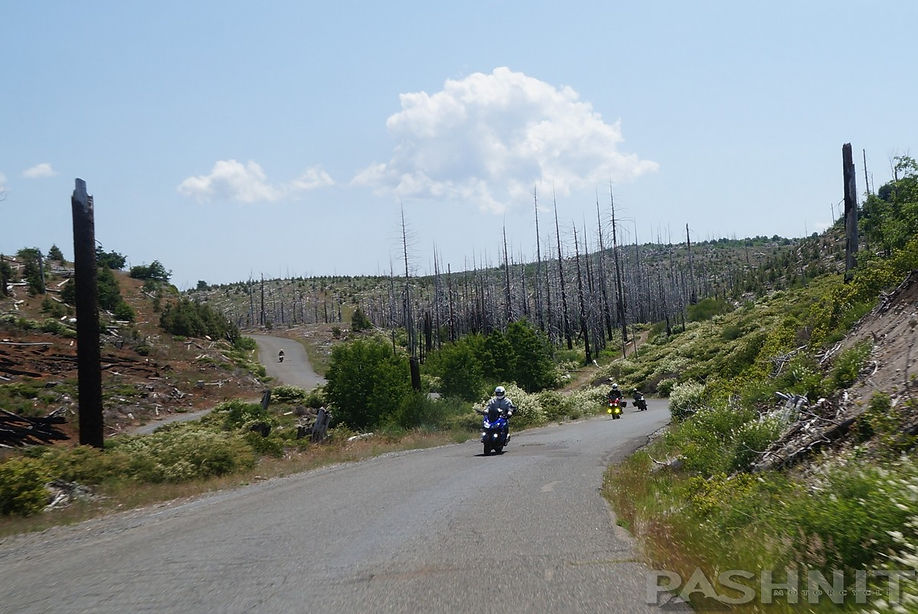
Let’s backtrack to the Blacksmith Flat Rd - Forest Road 23 hairpin just beyond Circle Bridge. Mosquito Ridge Rd is now atop the actual Mosquito Ridge and cuts through solid rock walls that occasionally drop truck-sized rocks onto the road.
The views of El Dorado Canyon below are stunning, expansive and worth a quick stop to take in the sense of space. You’ll be able to look directly down on Circle Bridge before continuing up the ridgeline.
The next six miles is the sequence that'll jump start your heart. This is also the section probably most photographed and recorded on video. With steep mountainside drop-offs, Mosquito Ridge is cut right through the rock, and the sheer walls often produce a fresh crop of rocks on the road, so be watchful.
Sixteen miles outside Foresthill, the canyon wall portion finally ends as Mosquito Ridge Rd runs through a sweeping 180-degree hairpin past Big Oak Flat Rd (gravel, gated) and begins to lazily curve along the top of the ridgeline passing by Peavine Rd, another dirt fire rd. Peavine connects to a labyrinth of fire roads to the north in the Tahoe National Forest.
Finally, at Interbay Rd, the ride settles down to a relaxed pace atop the ridgeline, curving through some very fun twists and turns. At several places, the ride pokes out of the forest exposing broad expansive views to the south across the ridge lines, the view is just beautiful.
Interbay Rd - Middle Fork Powerhouse
Interbay Rd heads south off the ridgeline to the canyon below to the Middle Fork Powerhouse power generating plant. (The adjacent hilltop is appropriately named the End of the World). The road is paved to the powerhouse, but it’s a dead end, there is no other road continuing up the other side of the canyon, you’ll need to ride down & back if you wanted to take a look at the powerhouse but this stretch of Interbay Rd is paved.

Riding beyond Interbay Rd on Mosquito Ridge, there is Spruce Creek Rd – NF 16, an unpaved fire road that loops around to Big Trees Grove Forest. East of Interbay Rd, a few miles of straights finally appear. However, before and after are larger than life sweepers, nearly 200 degrees around. Now picture that back to back. Just like heaven.
Twenty-four miles in on Mosquito Ridge Rd is NF 44 and a small historic marker for the gold rush town of Last Chance to the north of Mosquito Ridge Rd. The California Gold Rush in 1849 sparked the biggest mass migration in the history of the world. Between 1848 and 1852, four short years, California's population grew from 14,000 to 223,000.
Last Chance Ghost Town
Last Chance is one of these gold rush towns. The ghost town remains are 5 miles north via NF 44. At the Y, take the left road for another four miles on Last Chance Rd to reach the remains of the town at the edge of the canyon below. There are several abandoned buildings, old cars, and remaining portions of automobiles from the 1920s through 1940s. The El Dorado Mine is on the outskirts of the town and was a major commercial operation from 1890 until 1982. There are purported to be over 40,000 feet of tunnels radiating from the beginnings of the diggins. Last Chance was booming in the later part of the 1800s with a Masonic Lodge, several saloons and an Odd Fellows Hall.
By 1884, Last Chance had more than 25 homes, 7 saloons, a two-story hotel, several retail stores, a butcher shop, and a sawmill. A few wells, cellars and one cabin are the only evidence of this once thriving community ever existed. If you like Sierra Nevada ghost towns, there are many to explore.
Placer County Big Trees Grove
At the 25-mile mark from Foresthill while nearing French Meadows Reservoir is a sweeping hairpin where Spruce Creek Rd (NF 16) meets back up with Mosquito Ridge, a turn south here onto Jarvis Rd will take you .4 miles to the Placer County Big Trees Grove and a short distance beyond is the Big Trees Grove Campground. The entire grove, six living sequoia trees and two fallen giants, exists on about two acres in the middle of a 160-acre recreation area of the Tahoe National Forest, a demonstration forest that is the northernmost grove of giant sequoias in the Sierra Nevada range. With the idea being to grow new sequoias, two backup plantations have recently been established near the grove. Propagated from cuttings at the USDA Forest Service's Chico Tree Improvement Center, 10 tiny sequoias are just now pushing their roots into Sierra Nevada soil.
Salmon River Outpost: Somes Bar Store

There's a small parking lot here .4 miles off Mosquito Ridge, and sometimes used as a rest point for motorcyclists and car clubs. The six sequoias are not exceptionally large, the biggest is 12 feet in diameter and 250 feet tall. For larger sequoias, you should skip south to Arnold to Calaveras Big Trees State Park along Highway 4. Sequoia NP and Yosemite NP also have protected groves of giant sequoias, which grow into the largest trees in the world. “General Sherman,” in Sequoia National Park, is a 3,500-year-old sequoia tree. Its trunk is 102 feet (32 m) in circumference. At Calaveras Big Tree SP near Arnold, one of the sequoias was cut down in 1853 and the stump used as a dance floor (which you can still see today).
Robinson Flat Rd - NF 43
A few miles beyond the Big Trees Grove is Robinson Flat Rd - NF 43 which is an unpaved fire road over 7182 ft Robinson Mountain and connecting back to Robinson Flat Campground at the terminus of pavement on Foresthill Rd. Robinson Flat Campground is 7 family sites and 7 equestrian sites located 27 miles northeast of Foresthill at an elevation of 6,800 feet.

Mosquito Ridge Rd after Robinson Flat begins a slow descent to French Meadows Reservoir, el 5263 ft through several sweeping hairpins. The 1408-acre reservoir was completed in 1964 and is only nine miles from the crest of the Sierra Nevada range. Most of the water is released to the French Meadows Powerhouse located on the north shore of Hell Hole Reservoir to the south via an underground tunnel.
The McGuire Trail, French Meadows area, is a part of the infamous Western States Trail, winding through timber and following the north shore of French Meadows Reservoir. This short trail is a moderate climb to the top of Red Star Ridge, offering scenic views of the area. Horseback riding is outstanding on this trail as well. There is also camping along the east end of the lake.
If this is your first time on Mosquito Ridge, consider that few roads compare to this stretch of pavement. The one road that's similar is likely Cottonwood Road by Sonora, Mammoth Pool Road near North Fork or Angeles Crest above Los Angeles. You also must ride north 100 some miles and ride Oroville-Quincy Highway, more traffic, but just as good.

Can you see what's around the corner in the photo above? I couldn't. But just in case you really wanted to know, he's pictured staring at me. Forget all those stories of deer you've heard. This region is open cattle range, and cows wander freely in these parts. They generally have cow bells, you can hear them when you pull the bike over and shut the motor off when they are nearby. More cowbell.
I've ridden up on cows in blind corners like this one, walking down the middle of the road, or just plain hanging out nearby. And while I've yet to hear a story of a motorcyclist hitting a cow (bear or deer is more likely), they are not the brightest of animals.

Note any road over 4000 feet in the Sierra is over the snow line in winter, so snow may block the road and your ride may be limited in winter months extending all the way to Memorial Day depending on the winter.
Also note that law enforcement is spotty and seems to come and go through the years. Catchphrases like 'directed enforcement' were created because of riders coming up to roads like this and crashing. No one crashes, the cops stay home.
Squid behavior requires the use of the local paramedics, and gendarmes have to come see what the problem is. Over a decade ago, my email box was full of riders lamenting the Draconian policing of this road.

New season starts up, and nothing. Take that with a grain of salt. The years go by, riders come and go, but the road remains the same, always here, always waiting for you to enjoy it.
The ride reaches French Meadows Reservoir some 600 curves and 36 miles later after a 4000-foot elevation change. You can continue to head south across the earthen dam onto French Meadows Rd. Most of the campgrounds are located on the east end of the lake, and the road to reach them is on the southern end of the earthen dam.
Continuing south, the road name changes to Hell Hole Reservoir Rd, then Eleven Pines Rd to reach Wentworth Springs back (west) to Georgetown. East will take you to Ice House Rd & the Crystal Basin. f you like back roads, goat trails, or forest road sort of rides, you'll love Eleven Pines Rd. It has some great views just south of French Meadows Reservoir, oddly enough because the Penny Pines Fire in 2001 wiped out the forest in the region.

French Meadows Reservoir
French Meadows Reservoir is a man-made lake 36 miles northeast of Foresthill in the Middle Fork of the American River. The reservoir is 2.9 miles long, 0.6-mile wide, with 7.3 miles of shoreline.
Tahoe National Forest manages the recreational facilities which include five campgrounds, two group campgrounds and two paved boat launch ramps. Activities at the lake include power boating, kayaking, canoeing, fishing, picnicking and hiking. The reservoir is entirely within a state game refuge, so no firearms, pellet guns or archery weapons are allowed.

Continuing south from French Meadow Reservoir is the paved Eleven Pines Rd - NF 22, which is little more than a forgotten forest road. The road has been closed several times in recent years due to heavy winter rains that have washed away the road, however, Eleven Pines Rd is essential to keep open for fire-fighting and taking it south will link over the Rubicon River and connect back to Wentworth Springs Rd. It's the only paved road that connects these two reservoirs with Wentworth Springs Rd.
This region was extensively burned by the King Fire in 2014. In two weeks, the fire razed nearly 100,000 acres of forest originating from the edge of Pollock Pines. Prevailing winds blew it away from the town, saving the town of Pollock Pines from the fate of Paradise where in late 2018, the entire town of Paradise with 25,000 residents burned to the ground in the Camp Fire.
The Camp Fire burned 153,000 acres, killed 86 people, destroyed 18,804 structures and is regarded high on the list of the world's deadliest wildfires.

The King Fire burned 97,000 acres in 2014. French Meadows, Hell Hole and Loon Lake are seen at top middle. Eleven Pines Rd rides directly through the burn scar connecting to Wentworth Springs Rd.
The King Fire at left burned mostly national forest land and winds pushed the flames across the Rubicon Canyon all the way to Hell Hole Reservoir, with Eleven Pines Rd being in the center of the burned area.
Vast tracts of forest on both sides of Wentworth Springs Rd were burned east of Stumpy Meadows Reservoir.
In the aftermath of the 2014 King Fire (which was caused by arson, the suspect caught, convicted and sentenced to 20 years in jail and ordered to pay $60,000,000 in restitution), squabbles began regarding salvage logging, replanting and how to manage the forest.
You may see salvage logging in this region, despite most commercial logging ending in the early 1990s when the majority of the local mills either went bankrupt or closed down. Critics are quick to point out larger, more devastating fires started when the commercial logging ended.

King Fire seen from 50 miles away
6.5 Miles south of French Meadows, a 3-way junction appears, Google Maps labels this as Goggins. You won't find any town, but the Goggins Mine was once located nearby. One leg at this remote junction heads up to Hell Hole Reservoir, this is a dead end. The south leg continues as Eleven Pines Road - NF 22.
Hell Hole Reservoir
Hell Hole Reservoir is an artificial, crescent-shaped lake in the Sierra Nevada mountain range 10 miles west of Lake Tahoe. The lake is about 3.5 miles long when at full capacity. The lake is also so remote and far back into the Sierra, it's never busy or crowded. The road is paved all the way to the reservoir from Foresthill. The picture below of the author alludes to the stunning beauty of this region. The view at this overlook is worth the visit. Bring a bag lunch.
Hell Hole Reservoir was created in 1966 with the completion of Lower Hell Hole Dam across the Rubicon River, which is a major tributary of the Middle Fork of the American River.


Hell Hole Reservoir is named for a deep canyon which is now under the waters of the lake. The earthen dam was partially completed when a 1000-year storm spread across Northern California in December 1964, the earthen dam collapsed and debris flowed down the canyon, destroying several bridges and were finally contained by Folsom Lake. Read more about the 1964 flood.
The Hell Hole Campground features a view of the polished granite lake shore, but is not located directly on the shore of the lake because of the steep grade. The campground features a parking area, but the 10 campsites are walk-in only. Many visitors use Big Meadows campground, about one mile away, which has 54 drive-in campsites suitable for recreational vehicles.
The lake also features many small granitic islands that expand and contract with the level of the lake. Hell Hole typically has its highest level of water in May and lowers gradually through the summer and fall.

Hell Hole Reservoir
Eleven Pines Rd
Mosquito Ridge continues south across the earthen dam and becomes Eleven Pines Rd on the south side of the reservoir. This road is not for everyone, it's long at 35 miles and not fast, rather it's the opposite. Eleven Pines Rd ranges from poor in condition to smooth at times through nondescript burnt forestland, traversing two canyons. The King Fire skipped across the forest at times, leaving some stands of trees completely untouched, while burning intensely in other areas. Eleven Pines plunges down and up through two canyons, finally descending to the Rubicon River and across the 150-ft high Rubicon Bridge, then reaches Wentworth Springs Rd. Private forest lands have been replanted and the new trees are growing back quickly, the newly replanted trees can grow as much as 1-foot per year.
Turning east will take you to Ice House Rd, upon finally reaching Wentworth Springs Rd 35-miles from French Meadows Reservoir, which was graded smooth from a jeep trail to a wonderfully perfect motorcycle road in 2004. West will take you back to Georgetown for food and fuel. Georgetown is a quaint gold rush town connecting to Highway 193 which provides access back to Auburn to the north or Placerville to the south. Highway 193 also connects to Cool, the place I met the Speed Triple rider. This loop will take several hours, it's all paved but after Mosquito Ridge, it's rather slow-going. Also note there are numerous unpaved forest roads besides the ones listed here for all the dual-sports. Enjoy.
.jpg)
Eleven Pines Rd connects Mosquito Ridge with Wentworth Springs Rd - it's paved, but goaty.
.jpg)
Eleven Pines Rd connects Mosquito Ridge with Wentworth Springs Rd - it's paved, but goaty.
Other Rider Thoughts:
"Just finished reading your notes on Mosquito Ridge Road, and I do have to add something. The section of road from I-80 to Forest Hill has been heavily patrolled in the past by everything from local sheriff's to CHP. They can be real sticklers about the speed too, my wife (on a Triumph Legend) and a friend of ours (on a GSX1000R) tickets for doing 65 in a 55. The locals are pretty good sports about it though, they'll stop and warn you if you're pulled over taking in the vista's, tell you about where the radar traps are set up that day, and flash their headlights in warning if they don't see you stopped. As funny as it sounds, the last time I did that road and gassed up at that station in Forest Hill, the kind lady behind the counter took no less than three calls from people wanting to know if the law enforcement officers were out in force or not that day."
-Scott Caspe

Wow, I just got back from Mosquito Ridge. Are you kidding me? That was the most fantastic 36 miles of riding I think I have ever had. Not a car on the road. In fact, on the way out to French Meadows, there were zero cars. On the way back, we had to pass two, but that was it.
There were some motorcycles on the road, but a lot fewer than I thought. Those on the road were pretty advanced riders. One guy had titanium knee sliders and was sparking his way up the hill. Way cool! Anyway, thanks for the work you have put into your site, and thanks for showing me the key to happiness in my backyard. I love Northern California!
-Glen
Roseville, CA

To the Dual Sport Riders:
I have discovered a new world...dual-sports. I picked up an old '89 Honda NX650 trailie on the cheap, threw on some DOT-rated knobbies, bought some motocross safety gear, and hit the woods. WOW!
This is fun, oh so fun. I leave Travis AFB, roll up I-80 to Foresthill. But do I turn right onto Mosquito Ridge Rd this time? Oh nooo, I ride 10 more minutes and turn left into the Foresthill OHV area. About 100 minutes on pavement so far.
A few hours later I arrive back on pavement, with arms shaking from exertion, a mud-caked motorcycle, and a smile so wide I think I pulled a jaw muscle. I have just ridden a 340-pound trail bike into the deep, dark, mysterious world of dirt bikes. Snow, ice, thick mud, jumps, boulder, jagged rocks, giant roots, trees....all were encountered with glee.
There are 80 miles of trails in the Foresthill OHV...I don't think I've ever encountered a better case of "your tax dollars at work." Bless the folks who manage the Foresthill OHV! And there are LOTS more OHV areas scattered all over California? Damn I love this state.
Rick Williams
Travis AFB, Calif
Spillway at French Meadows Reservoir overflowing

While back in the day...
The Auburn Sentinel ran a front-page article on motorcyclists on Mosquito Ridge. They focused on speeding and frequent crashes and injuries. The reporter talked to one emergency responder who that day rescued a high school friend who was hurt in a crash. Your site was briefly mentioned (but not by name, if I recall) as contributing to higher numbers of cyclists.
Easter Sunday, I decided to take advantage of the perfect weather and headed from Grass Valley to Foresthill. It's just over an hour on the back roads I like: Dog Bar to Placer Hills road, out of Auburn on the 49, drop down to the river, don't turn across the bridge, but continue past the confluence where the road becomes Old Foresthill, up the hill, past the entrance to the OHV area until you meet Foresthill Road proper.
Nice and easy out to Foresthill (three CHP in 15 miles), where I stopped at the gas station next to Robber's Roost. Three riders there said they hadn't been out yet, and only a couple bikes had gone by. Off to Mosquito Ridge road.
Five minutes later I got nicked going 46 in a 40 at the 4.5 mile mark by a ranger with a serious attitude problem. He was stopped in the middle of the road ahead of me waiting. And man, you'd think I killed his dog by the glares he gave me. Respectful "yes sir", "no sir" answers got condescension and antagonism.
He was in my face like he was trying to pick a fight. What a prick. Although he was a bad example of what happens when you give an asshole a gun, he let me go with a warning. I'd rather the little peckerwood gave me a ticket.
Anyway, I continued to the 26-mile mark (at the posted limit of course) without further incident. A few points found some rocks on the road, and snow blocked one lane for a hundred yards or so at two or three spots beyond mile 24.
I turned around after stopping briefly at Big Trees picnic grounds, where the latrines are closed for winter, and the water is still shut off. On the return, I saw two forest service trucks shooting radar and a CHP passed me headed outbound. All of them were from about mile 15 and in. Foresthill Road back to Auburn saw another three CHP cars. None of them were keen (thankfully) on making U-turns.
I concentrated the afternoon on my own Nevada County roads: Wolf, Lime Kiln, McCourtney, Indian Springs, Bitney Springs, Rough and Ready Highway, Pleasant Valley Rd, etc. Beautiful rides those, and law enforcement is both less concentrated and more reasonable.


Mosquito Ridge Rd - Photo Gallery


MORE INFO:
Mosquito Ridge Rd
36 Miles - Foresthill to French Meadows - FULL LENGTH
Remote mountain road, well-maintained, usually good - PAVEMENT
Severe canyon drop-offs, smooth hairpins - CURVES
Foresthill to French Meadows to Hell Hole Reservoir- CONNECTS
Foresthill, Georgetown - GAS
Auburn - LODGING
5200ft - PEAK ELEVATION
Stunning views, length, endless twisty road - HIGHLIGHTS
GPS LOCATION
39°1′10″N 120°50′10″W - Foresthill
39°06′42″N 120°28′06″W - French Meadows Reservoir
LISTED SIDEROADS:
Old Auburn Foresthill Rd
Lake Clementine Rd
Soda Springs Rd
Ponderosa Rd (dirt)
Yankee Jim Rd (dirt)
Spring Garden Rd
Sugar Pine Rd - NF 10
Iowa Hill Rd
Blacksmith Flat Rd - NF 23
Rubicon Rd
French Meadows Rd
Ralston Ridge Rd
Ramsey Crossing Rd - FR 13N65
Peavine Rd
Interbay Rd
Spruce Creek Rd - NF 16
Jarvis Rd
Robinson Flat Rd - NF 43
Hell Hole Reservoir Rd
Eleven Pines Rd - FR14N08 - NF 2
Wentworth Springs Rd

Maps


Suggested Day Ride:
Plan a day ride starting in Auburn, and ride a half-day half circle loop through the Sierra Nevada Mountain Range:
Foresthill > Mosquito Ridge Rd > French Meadows Reservoir > Eleven Pines Rd > Wentworth Springs Rd > Ice House Rd > Loon Lake > Big Hill Fire Lookout > Ice House Rd > Highway 50 > Silver Fork Rd > Mormon Emigrant Trail > Pollock Pines