(65) Fountain Springs to Western Divide Highway
Southern Sierra, California
Hot Springs Rd

Mountain 50 - Parker Pass
32 Miles - LENGTH
County highway, maintained, fair - PAVEMENT
Eleven sets of hairpins - CURVES
Fountain Springs to Western Divide Highway - CONNECTS
Ducor, Kernville - GAS

Journey to Apocalypse Valley
Every apocalypse movie I've ever watched as a kid had one thing in common. The retreat into the hidden valley. The apocalypse arrives and the townspeople all head back into the hills where the baddies won't find them. They live a peaceful existence singing kumbaya and holding hands, living off the land with one another in perfect harmony.
My moment was Red Dawn, when this film came out in 1984, as a 13-year-old kid, Red Dawn was so scary of a movie, I had to cover my eyes and peer through my fingers. While other kids were traumatized by Jaws (my wife refused to swim in pools), mine was Red Dawn. The movie by itself isn’t scary, rather, it was the idea of the United States invaded by the Soviet Union that made it scary at the height of the 80s Cold War.
Under Ronald Reagan, our arch nemesis was the Soviet Union, who our president called an ‘Evil Empire’ one year prior in 1983. In Red Dawn, the Soviet Union (along with Cuban and Nicaraguan allies) invades the United States by parachuting into Colorado. Our intrepid heroes, led by the late Patrick Swayze, retreat into the mountains and fight the Evil Empire in guerrilla warfare. The theme fit nicely into a popular movie genre of the time. That same time period, The Terminator was released with similar themes of nuclear annihilation (this time headlined by a killer android played by Arnold Schwarzenegger). The Day After in late-1983 also gets added to my all-time terrifying movie list. (Threads was the UK-equivalent in 1984.) What commonality did these scary films of my childhood share?
The retreat into the hidden valley. And, where would the townspeople go when this nuclear apocalypse scenario arrives? Kids, I found your valley. Put a gold star on your map and start prepping.

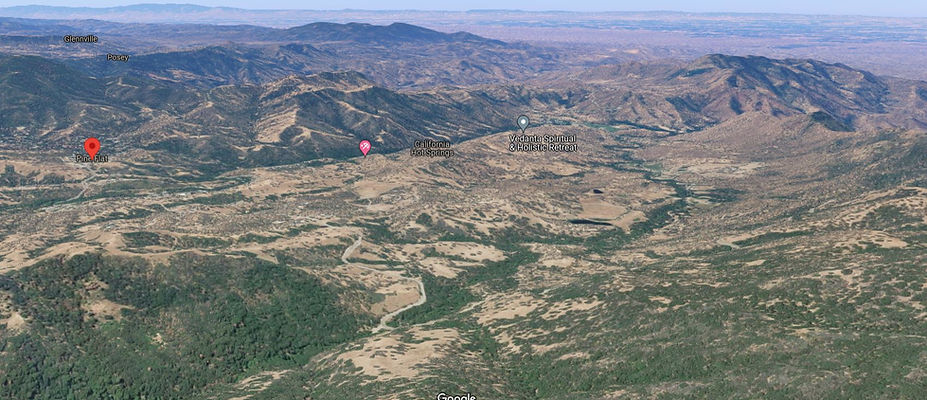
Known as California Hot Springs and Pine Flat, this mountain valley, with the less scary name of Quail Valley, is surrounded on four sides by mountain ridges with one paved road in and out of the valley.
The first time I went looking for Mountain 50 in and out of this valley, I got lost, disorientated, rode into Sugarloaf instead and stumbled purely by chance onto The Road with No Name, better known as Forest Road 23S16. FR23S16 is a single lane paved mountain road you’d likely never discover on your own.
Back in the olden days of paper maps and terrible directions, once you rode off the edge of the map, you were on your own. I missed Apocalypse Valley by a country mile and rode right around it instead. Such occurrences are long gone due to whatever mapping program you're using, and it's not likely you would have any reason to ride Parker Pass Rd, also known as Mountain Road 50.

Set your meet point for this ride at Fountain Springs

Think of Parker Pass as a backdoor into the Southern Sierra Nevada Mountain Range. It leads up and over to the Kern River Canyon, or Highway 190 - Western Divide Highway, into Springville. This highway is carved into the spine of the Sierra Nevada range. However, and here comes the good part, Parker Pass Rd heads up to the top of the range where giant sequoias and expansive views of the Kern Canyon are waiting for you to explore.
The way into Apocalypse Valley (Lighten up Francis, that’s not really what it’s called, I just made that up) is known as Hot Springs Rd. This ride begins at an intersection at Fountain Springs, located in the center of Southern Foothills ranch land.
This remote intersection is better known as the Old Stage Saloon at Fountain Springs, a saloon and bar. Fountain Springs is directly south of Porterville and east of Ducor (gas) and little more than a remote intersection. The saloon on the corner dates to 1858 and was originally a station on the Butterfield Overland Mail stage route. Established in 1858, the historical Fountain Springs was a station on the Butterfield Overland Mail route, 14 miles southeast of Tule River Station and 12 miles north of Mountain House from 1858-1861. The Butterfield Overland Mail was a stagecoach service that carried passengers and U.S. Mail from Memphis, Tennessee, and St. Louis, Missouri, to San Francisco, California. In the present day, the saloon makes a great midday stop if you can time your arrival for lunch. Fountain Springs was named in 1855 by early travelers on their way to the mines along the White River.


Layers of ridges glow in the morning sun
Hot Springs Rd - Mountain 56 leaves the Fountain Springs Saloon behind and begins the climb into the Sierra Range, a meandering foothill ride at first over lazy curves, and an ever-increasing elevation, climbing a vertical mile over the next 32 miles. A sign for ‘Chains required at any time’ flashes by.
When winter rains arrive, these rolling hills instantly turn glowing green for a few months. Usually by May, the rainy season is over, and a golden burnt brown color returns to the treeless landscape of ranch land. Hot Springs Rd is fast, typically deserted, and the curves are lazy, meandering between the low hilltops. Your ride day starts with grassy rolling hills that heave and sigh, where road crews cut around hilltops instead of through them.

First glimpse of Apocalypse Valley - surrounded on four sides by mountain ridges
This is a place where roads are allowed to cling to the contours of the land. Ranches and homesteads are sparse, separated by pastures adorned in grazing cows or horses. Large house sized granite boulders are strewn about this region, indigenous to this elevation of the foothills.
Numerous pullouts in this section occasionally offer a look back at the Central Valley as the elevation begins to climb. Most days a haze pervades over the valley obscuring the view, but there may be days where conditions are just right, after winter rains or a crisp cold morning, and you’ll be able to see clear across the 70-mile-wide valley to the Temblor Range. Rolling pastures for grassy hillsides give way to spare tree cover while banked corners appear labeled at 30 mph and the bike beneath you rockets forward, ever onward.


Glimpses of Apocalypse Valley begin to appear as the Sierra Nevada Range draws closer in the distance. At the right time of year, snow caps the peaks in the distance. Road surface deteriorates in this stretch to the summit but could be described as fair for a county road. At the barely perceptible summit, Hot Springs Rd leans left and pops out into the Apocalypse Valley with expansive views of the valley below. A mountain ride wouldn’t be complete without hairpins and this stretch of Hot Springs Dr offers up wiggly hairpins headed down into our Apocalypse Valley.
Rolling into the valley, at the base of the hill is Hot Springs Elementary School, a tiny elementary school with 19 students spread over grades K-8. The school secretary is also the bus driver. Across from the school is a small fire station. Adjacent to the school is the Quail Valley Recreation Village that offers 102 RV sites plus you can camp here. At Quail Valley Recreation Village is Tyler Creek Drive which is paved for the first few miles, but dead ends at a homestead further up the road. Around the bend from Tyler Creek Rd is the Deer Creek Restaurant which also functions as the local bar, and small store for community residents. Another great lunch option to plan into your ride.
Vedanta Spiritual & Holistic Retreat, a short distance away, is positioned at the very edge of the Sequoia National Forest border. Vedanta Spiritual & Holistic Retreat is a spiritual retreat, eco village and an international center for holistic learning, helping to unfold a new human consciousness and create a positive and sustainable future.


California Hot Springs prior to the 1968 fire that razed the town - Photo credit to Paul Smith

The Sequoia National Forest covers over 1.1 million acres spanning three counties. The national forest offers 52 developed campgrounds, hiking on more than 1,147 miles of trails including 47 miles of the Pacific Crest Trail, over 314,448 acres of wilderness, 222 miles of wild and scenic rivers, 2,617 rivers and streams, world-class whitewater rapids, 158 ponds and lakes, boating, fishing, biking, horseback riding and more.
A white brick building just beyond the national forest boundary with Welcome to California Hot Springs set off the curiosity stream inside my brain. It appears as if a gas pump could have been located here and this building functioned as the town garage. Little hint of a town remains.
Town lore says the majority of California Hot Springs burned down in 1968. In present day, can’t call it a town, barely 50 people call this valley their permanent home. After the fire in 1968, almost nothing was rebuilt except the California Hot Springs Resort was purchased in the 1980s and refurbished. The massive pool out front of the building looks alluring on a hot summer’s day. The large pool is heated with hot spring water plus there are two hot tubs with two different temperatures.
California Hot Springs Resort in present day offers a small curio shop, cabins and a small RV Park, but is likely best known for their swimming pool right beside the road. No website exists for this facility other than a Facebook page. They are supposed to open every day except Thursdays.
California Hot Springs
The first people to use the hot springs were the Bokninuwad Yokuts also called "Hoeynche" who called it "Kahtil Ilkau" hote water. In the late 1870s T.J. and N.B. Witt filed claim to Upper Deer Creek "Hoyen Idik" which included several hot springs. They were then known as the Deer Creek Hot Springs. By 1880 the Witt Family had developed small bathhouses and that it sold several more times. During that time the name became California Hot Springs and was praised far and wide for its health benefits. In 1904 a large hotel was built called Del Venado. It burned in 1932, but within two years, new facilities were built. The names of Firebaugh, Pike, Wingrove, Mitchell, Williams, Newbury and Baxter show as owners over the years until a disastrous fire in 1968 destroyed the resort buildings, leaving only the dance hall, swimming pool and a few rental cabins. In the 1980s the Gilbert Family purchased what remained and with great effort brought it back to what it is today, an active successful resort.

A small community of Hot Springs Rental Cabins along Deer Creek rounds out California Hot Springs and it’s time to push into the Sierra Nevada range and out of the Hidden Valley.
Pine Flat
Hot Springs Rd ends at a hairpin-intersection 1-mile beyond the California Hot Springs Resort. Now, if you weren’t paying attention, you’d ride right into Pine Flat, but Mountain 50 begins climbing into the mountains here splitting off at the hairpin into Pine Flat.

If you're not paying attention and you simply follow Hot Springs Rd,
you'll ride right into Pine Flat and miss your turn
Pine Flat is a small mountain community of about 150 people tucked away from the world. It does have a tiny town center with a church, a general store, a small motel (unconfirmed if this is still open), and the Seven Oaks Market & Grill. Seven Oaks has a full grill here serving breakfast and lunch along with outdoor seating. The paved road through Pine Flat only lasts 2 miles before Pine Flat Rd devolves to a narrow single lane dirt road.
Some on-line mapping programs show this road connects to Sugarloaf. Technically, it does via Forest Road 23S05, if single lane dirt mountain road is your thing, have at it. However, if you prefer pavement, this is not your road. Ironically, this is the road I was looking for oh so many years ago when I rode off the map and got lost in the Sierra Nevada Mountains discovering Forest Rd 23S16 instead.
The USFS - Hot Springs Work Center is based here at the hairpin intersection with the entrance being barely visible in the photo at right. A short distance up the road is a parking area at Tyler Creek in another hairpin. The original single lane bridge is still here from decades ago next to the parking area. Seek it out if you like bridge hunting abandoned bridges.
This parking area is also for the Tyler Creek Trailhead if hiking is your thing. Walk up Tyler Creek and the Lion Ridge Trail flows up the spine of Lion Ridge. Tyler Creek Trail also leads to the Starvation Creek Grove of sequoia trees following Starvation Creek via the Powderhorn Trail. Mountain Road 50 climbs 3600’ to 6400’ through 10 hairpins to gain the elevation to Parker Pass.

Name change to Mountain Road 50 to continue the ride to Parker Pass - note the sand
This parking area is also for the Tyler Creek Trailhead if hiking is your thing. Walk up Tyler Creek and the Lion Ridge Trail flows up the spine of Lion Ridge. Tyler Creek Trail also leads to the Starvation Creek Grove of sequoia trees following Starvation Creek via the Powderhorn Trail.

Mountain Road 50
Mountain Road 50 introduces itself with a rapid 12-mile climb to the Parker Pass Summit. While viewing the multiple hairpins, twists and turns via your mapping program and this site, you might assume this is a fast road, but to the contrary, it’s the opposite. This is a road where you should slow down and drink it all in. Broad open views along the climb allow an unobstructed view of Apocalypse Valley down below the road. A bonus is able to see Mountain Road 50 below, the road you’ve just come up. There are several pullouts in the climb up the mountain side that offer expansive treeless views. Merry Camp Trailhead is a short distance up the hill from Tyler Creek and climbs up along Rube Creek to 6200’ Hatchet Peak. A tiny sign labelled 23S31 denotes the trailhead.

Viewed from Mountain 50 - Expansive views of Apocalypse Valley - surrounded on four sides by mountain ridgelines,

Hairpins, hairpins, and more hairpins climbing into the Sierra Nevada Range
King George Peak at 4377’ dominates the western border of the basin below the road. Make this short stretch your planned break, bring a snack, something to quench your thirst and pull to the side of the road to drink in the sounds, the smells and by all means, the view. Few people use this road, fewer still even know about it. At the 5000’ level, the vegetation begins to rapidly change to stands of digger pines. The valley for Cold Springs Creek begins to narrow as you near top of the range. Multiple hairpins also mean numerous views of the Hidden Valley below. Just when you think this road can’t fold in on itself, another hairpin presents. Nearing the summit is Mountain Road 504 - Forest Road 23S64, a dirt fire road that circles across Windy Creek, Bear Creek, and hooks back up with the paved Forest S23S16 (while running parallel to the paved Mountain 50). Dual sports take note. The top of the range appears to be right in front of you, and that’s likely because it is right there, close enough to touch.

Overview of Apocalypse Valley, Pine Flat at left, California Hot Springs at center
Those who prefer to explore the most remote sequoia groves far away from the tourist traffic, take note of FR 23S68 found in one of the last hairpins headed up the hill. In the apex of the hairpin is a dirt road that leads to a parking area. There are no signs at Chute Spring, but this dirt road leads to the Starvation Creek Grove of sequoia trees. Starvation Creek Grove is a remote sequoia forest in Tulare County and has an elevation of 5,673 feet. Starvation Creek Sequoia Grove is situated west of Powderhorn Grove, and east of Mud Spring. Some maps label this dirt road as Parker Pass Rd but the road ends at the sequoia grove. Common sense says do advance homework before heading off the main road into the forest.

At 5800’, the ride finally nears the summit at Cold Springs Saddle. Fences line the road denoting summer pasture land for cows along with cattle grates in the road. A few more wiggles and Mountain Road 50 tops out at 6400’ hitting the summit of Parker Pass.
The top of the range here is mostly flat, but holds numerous broad grassy meadows accessed via a labyrinth of dirt fire roads. Parker Meadow at 6437’ is .5 miles off Mountain 50 via Forest Road 22S04. These shallow treeless depressions at the very top of the Sierra collect all the runoff and are covered in green grass.

After ten sets of hairpins, Mountain 50 finally reaches Parker Pass
Where to next?
Mountain Road 50 reaches the Western Divide Highway at what appears to be a four-way intersection. Sort of. The turn south pulls into a dirt parking area. If you want to ride one of the twistiest roads in the state, continue north onto the Western Divide Highway but don’t miss the Trail of 100 Giants a few hundred yards from the intersection. Mountain Road 50 continues another 6 miles eastward now headed downhill into the Kern River Valley. But the designation ends at the R-Ranch in the Sequoias at Johnsondale and has a name change to Mountain 99 as it reaches the Kern River. The northern terminus for FR23S16 - Portuguese Pass is found in this downhill stretch and really is a unique motorcycle ride, unlike anything in the state.
Worth mentioning that Johnsondale appears as a town on every map, but there’s no town here. Johnsondale is a RV community with 250 sites and was originally a logging camp. There is a small general store here for campers plus a restaurant known as the Johnsondale Hilton. Before it was a private development, the ranch was the Mount Whitney lumber company town. It is surrounded by more than 866,000 acres of the Sequoia National Forest and Monument at an elevation of over 4700 feet and spans 750 acres. Referred to as “cabins,” more than 80 individual housing units are actually small homes initially occupied by the lumberjacks that lived full time in the camp. Some of these rustic cabins can be rented as vacation rentals.
Those that are continuing due east will reach Sherman Pass Rd at the Kern River at the bottom of the canyon. Sherman Pass is a must ride, but very remote exiting to Highway 395 via Nine Mile Canyon. Following Mountain Road 99 south leads to gas and lodging in Kernville. A word of mention is if headed down the Kern River Canyon, keep a keen eye out for river revelers backing vehicles out onto the highway without paying even an ounce of attention.

Sherman Pass - Nine Mile Canyon
Do it right and combine Parker Pass with Sherman Pass. The Sherman Pass ride deserves its own separate article, all in due time, for now, let’s spend two shakes on this 9200’ mountain pass. Sherman Pass has one of the most dramatic mountain climbs railing through numerous hairpins to rapidly gain elevation out of the Kern River Canyon. Easily passed over and forgotten as the black sheep of the family, Sherman Pass pales in comparison to its northern neighbors. It’s remote, requires special planning to ensure you have enough fuel for the trek and there’s nothing up here other than the tiny mountain community of Kennedy Meadows. There is an above ground fuel tank at Kennedy Meadows and a small restaurant here.

Sherman Pass is a bucket list ride and one of the least known Sierra Nevada Passes
Sherman Pass Rd once it reaches the 9200’ peak elevation is a relatively flat ride across the Kern Plateau, albeit a twisty one with Kennedy Meadows oasis at the mid-point. The high mountain Kern Plateau is best known to dirt riders who trek up to numerous national forest campgrounds, and ride dirt bikes on countless national forest trails in the semi arid high mountain elevation. Sherman Pass combines with Nine Mile Canyon to drop back down the Eastern Sierra to reach Highway 395. Sherman Pass is all paved and well-worth the trek for any motorcyclist. Sherman Pass is closed during winter but we've been told by locals it's plowed to Kennedy Meadows from the Nine Mile Canyon side due to the lower elevation on the eastern half.

This map only highlights Sherman Pass Rd, but the ride does connect to Highway 395 via Nine Mile Canyon
Hot Springs Rd - Mountain 50 - Bonus Photo Gallery


MORE INFO:
Hot Springs Rd
Mountain 50 - Parker Pass Rd
32 Miles - Fountain Springs to Mtn 107 - LENGTH
County Highway, Fair - PAVEMENT
Numerous, sheer mountain drop-offs, no guard rails - CURVES
Fountain Springs to Western Divide Highway - CONNECTS
Porterville, Ducor, Kernville - GAS
Porterville, Pine Flat, Johnsondale, Kernville - LODGING
6400 ft - PEAK ELEVATION
Remote mountain valley, little known route - HIGHLIGHTS
GPS LOCATION:
35°52′49″N 118°40′25″W - California Hot Springs
LISTED CONNECTING SIDEROADS:
Highway 190- Western Divide Highway
RELATED LINKS:
Old Stage Saloon, Fountain Springs

Maps