Coulterville to Bear Valley
Central California
Highway 49
22 Miles - LENGTH
Dreamy- PAVEMENT
Hairpins, Tight, Many, Switchbacks - CURVES
Coulterville to Bear Valley - CONNECTS
Jamestown, Greeley Hill, Mariposa - GAS
Highway 49 - Yuba Pass

Quick Ride: Adored stretch of canyon loved by local motorcyclists, a non-stop twisty section of road all riders shouldn't miss. Stunning views, overlooks, many pullouts. Recently repaved.

The Little Dragon
Read about Highway 49-Yuba Pass here.
Highway 49 is a rather long road- in fact, it runs for 284 miles through the heart of the historic regions of the Gold Rush. Much of Highway 49 is just that- a highway. And a main highway at best. Busy, congested, and bogged down in a train of tourist traffic. Plowing through small towns with names like Chinese Camp, Sutter Creek, or Drytown- Highway 49 is more so the home of the RV traveler than the motorcyclist seeking a dose of twisty goodness.
So out of all that 284-mile distance, why the focus on a short 15-mile stretch of pavement?

Well, imagine if you could escape all the aforementioned issues, the towns, the people. Instead, step into another world of motorcycling bliss. All in the pursuit of twisty goodness.
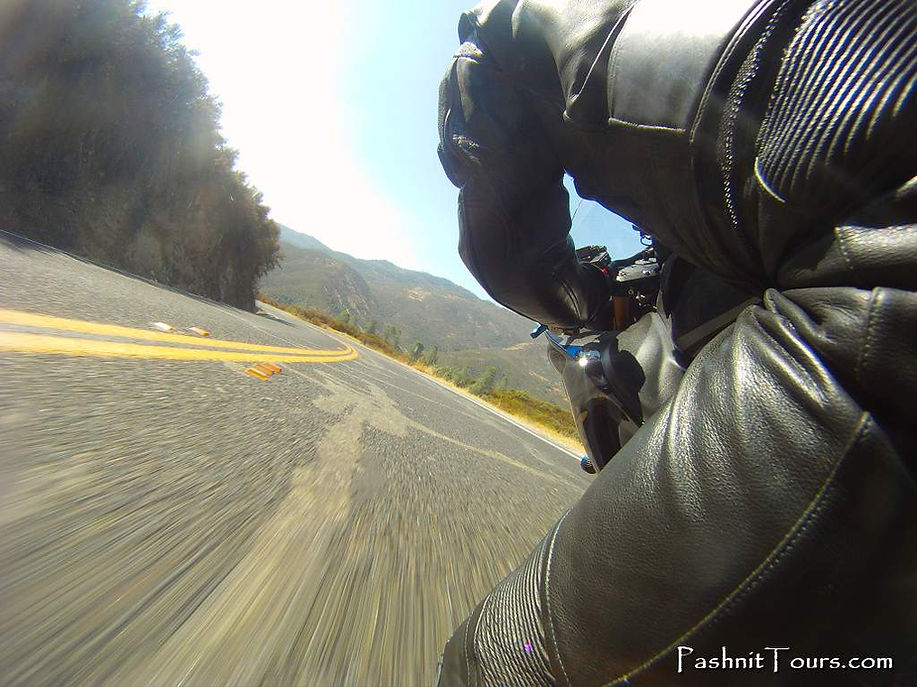
You want to ride some fantastic curves- bask in the sensation of super-smoothness rotating beneath you, to climb to the top of the mountain and suck in some air as you utter a gasp at the view- which stretches on for miles across the foothills. Want to wet your whistle on a dreamy slab of blacktop designed, thought up, and intended for motorcyclists? Like the sound of that?
We've got just the thing. A mere 15 miles indeed. A shot in the arm then is all you really need. A dose of twisty goodness.
The Little Dragon is generally thought of by local riders as a canyon between Coulterville and Bear Valley. Neither town is large. Coulterville is nothing more than an intersection of Hwy 132 and Highway 49. A mere hint of a town that teamed with the lives of 4000 people, 1000 of them Chinese. Coulterville was named after George W. Coulter who in 1850 set up a few tent stores in the general region of the foothills along with partner George Maxwell.
Named Maxwell's Creek in 1853 when the first Post Office was established, it was eventually renamed Coulterville in 1872. Coulter's tent expanded to become a store to supply the miners headed for the gold fields, then eventually a hotel around which a town sprang up.
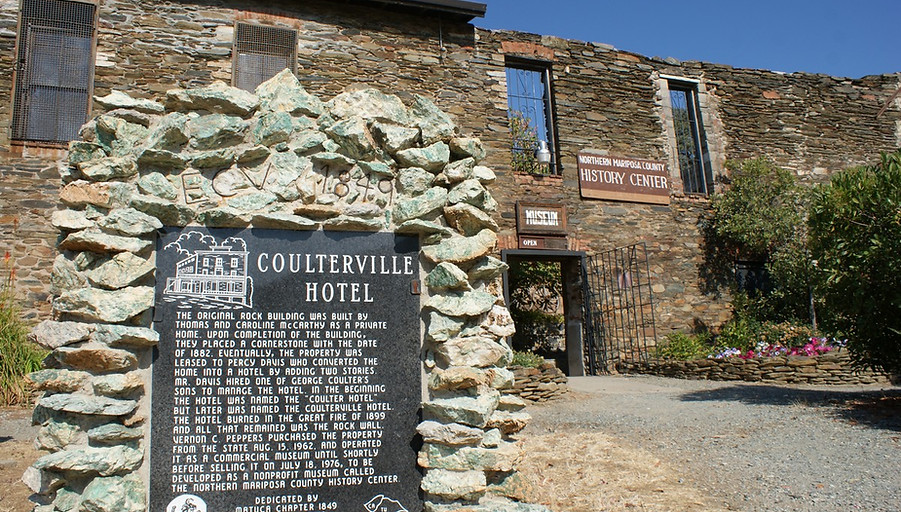
Built in 1851, the Hotel Jeffery, with walls 3 feet thick, still stands on the corner of Hwy 49 & Hwy 132. (The hotel isn't currently open for business.) The town soon expanded to ten hotels and twenty-five saloons. While the town is quiet these days, it is a favorite stopping & rendezvous point for northbound riders that have just ridden The Little Dragon, or are about to. East of the intersection is a small general store for some quick snacks and something to drink. On the west side of Highway 49 across from Hotel Jeffrey is a railroad train car that's been turned into a vacation rental.


Today, there's little hint of the town’s former hubbub, in fact Coulterville is one of the tiniest active towns along Highway 49 at just 200 residents. A few small shops surviving on tourist traffic and the occasional motorcyclist. There’s a small museum across the street from the Hotel Jeffery on the northwest corner of the junction that is worth checking out.
Adjacent to the museum is “Whistling Billy”, an eight-ton Porter Locomotive that was shipped around the Horn and brought to Coulterville by mule team to bring gold ore from the Mary Harrison Mine four miles to the “Forty-Stamper” mill. The locomotive stands under the town’s Hanging Tree, from which the likes of Leon Ruiz was hung in 1856 for robbing and killing two Chinese miners.
Eastbound from Coulterville is Greeley Hill Rd to Smith Station Rd up to Highway 120 and into Yosemite NP. Note across the highway is Ferretti Rd that circles around to Wards Ferry Rd and the famous Graffiti Bridge back to Sonora. Up Highway 120 from that junction of Smith Station Rd & Highway 120 is the entrance to the Cherry Lake Loop to Tuolumne. There is no gas in Coulterville, but there is gas 7 miles up the hill in Greeley Hill. Pick a direction, any route is amazing motorcycle roads.
It gets better. Worth noting, another favorite of Pashnit Tour riders is Priest Coulterville Rd, which runs parallel to Highway 49 into Priest along Jackson Ridge. Combine that with the super-steep Old Priest Grade or the smoothly twisting Hwy 120 bypass up Old Priest Canyon, and you could run circles all afternoon. Old Priest Grade is 2 miles long and was first opened in 1874 built for stagecoaches and freight teams.
In 1874, the grade was so steep, passengers were made to get out and walk the 2 miles up the grade to Priest at the top of the ridge where a small coffee shop operates with several rental motel units behind it. The balconies look directly down on Old Priest Grade. Not much has changed, large vehicles and those with trailers are prohibited. The road is so steep with an 17-20% grade, you can only park pointed uphill on the bike, and there are no pullouts to park, although I have tried several times over the last 20 years to photograph the road. Some riders claim it’s one of the steepest roads in the state. The Moccasin Powerhouse sits at the bottom of the grade. From Moccasin, twisty motorcycle roads surround in every direction.

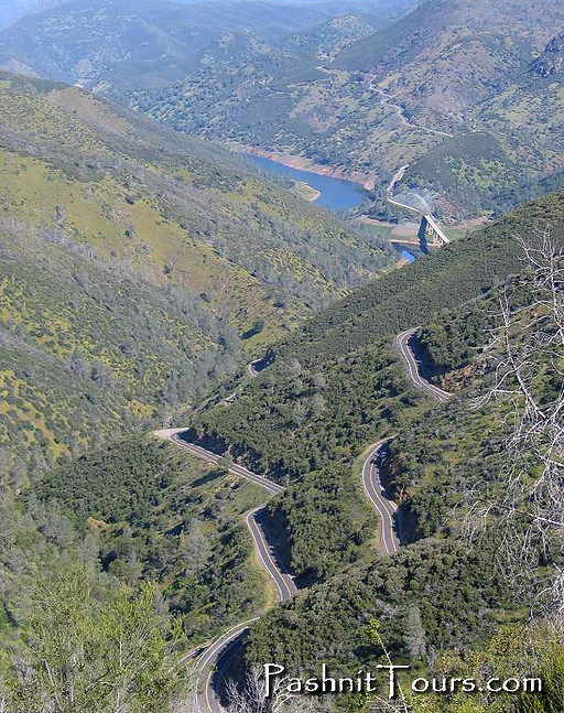
If you're heading southward, leave Coulterville and get prepared for a thrilling stretch of pavement. The ride itself is a smooth one, but a with heavy dose of twisty goodness. Highway 49 leaves Coulterville in a gentle uphill stretch building a crescendo as you pop over the ridge and begin twisting back and forth. To the south, the road stretches off cut into the ridgeline, so enticing and intoxicating to look at, you will need to stop and pull over to grab a photo. Who would believe it even if you attempted to describe it.
A pickup towing an RV or trailer might be commonplace, but the road delves out an occasional place to pass. Weekdays of course will yield the least encumbered ride. And occasionally on a quiet day when the motorcycle gods smile on you, you’ll be completely alone and have the road all to yourself.

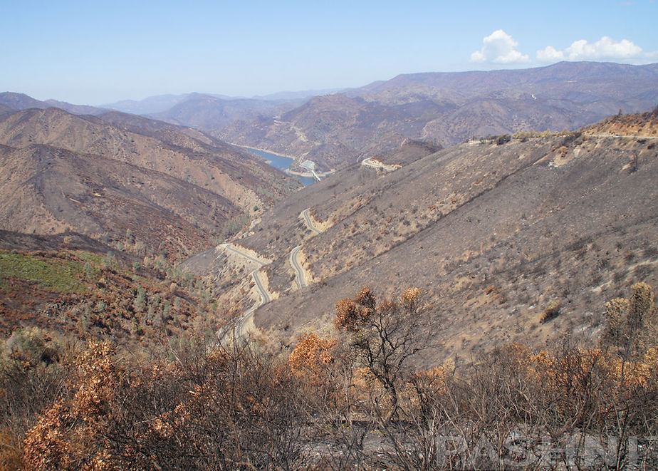
The Detwiller Fire in July 2017 burned 80,000 acres and burned out the entire Bear Valley that The Little Dragon sits in. The elevation is too low for any pine forest like you’re thinking in the Sierra Nevada, rather this 2000 ft elevation is all scrub brush and an occasional digger pine that can handle the summer heat and many months of zero rain. The underbrush comes back quickly, but the burn scar that took out all the few trees will remain for years opening up all the sightlines along Hwy 49. Any other vehicles you’ll be able to see a long way off. The fire line starts outside Coulterville and extends all the way to the very edge of Mariposa.
A major hazard in this section is when vehicles cut the corners, kicking rocks and gravel dust up on the road. Each time you ride this stretch, you’ll need to be extra careful and expect the sand to be there. Road cuts occasionally are poor and extend to the edge of the pavement, sand or gravel settles down on the inside lane so be forewarned.
One of the rules in the Pashnit Motorcycle Tours safety brief is ‘There are No Surprises in Riding’. If you were surprised by anything on this ride, you’re going too fast for conditions, your skill level or your bike’s capabilities.
Surprised by sand in the road? Nope. You should expect it to be there, it’s predictable and depending on the season, it will be there.
During spring, brilliant green grass blankets the hillsides and makes for a enthralling scene. By Memorial Day, the heat arrives, the rains stop and these canyons can be very hot, easily well over 100 degrees as you ride down into the Merced River Canyon. The grass is all burnt by the heat, and it’s brown, brown, brown.
Numerous pullouts line both sides of the road at random intervals, and the slow truck in front of you may even pull over to let you pass on by. A few miles outside of Coulterville, Hwy 49 pops over the ridgeline crest and begins a slow descent. Sight lines include the adjacent Hunter Ridgeline on the other side of the Merced River anchored by 2681 ft Hunter Valley Mountain.
After the ride rolls past several old gold mines such as the Harrison & Virginia Mine, the road steadily makes its way towards the Merced River Canyon bottom, an oft glassy smooth tributary of Lake McClure. At the top, is a fantastic vista called Virginia Point with a classic photogenic view.
The road winds down the hillside to the former site of Bagby. Nearby is the Bagby Recreation Area to the east. Bagby Campground with 30 campsites is located on the far eastern arm of Lake McClure where the Merced River feeds into the lake. The campground is only a short distance off Highway 49 south of Coulterville. When the lake is full, Lake McClure is 7000 acres and 20-miles long. Depending on the time of year, the Merced River at Hwy 49 will be an extension of Lake McClure. There are campsites here right on the edge of the water where during years where the reservoir is full, you could park your boat right near your campsite. The boat launch is also here at the Bagby site.
In dry years like the drought we had a few years ago, barely any water was in the valley.

What my Avon tires on my TL1000R look like after riding The Little Dragon

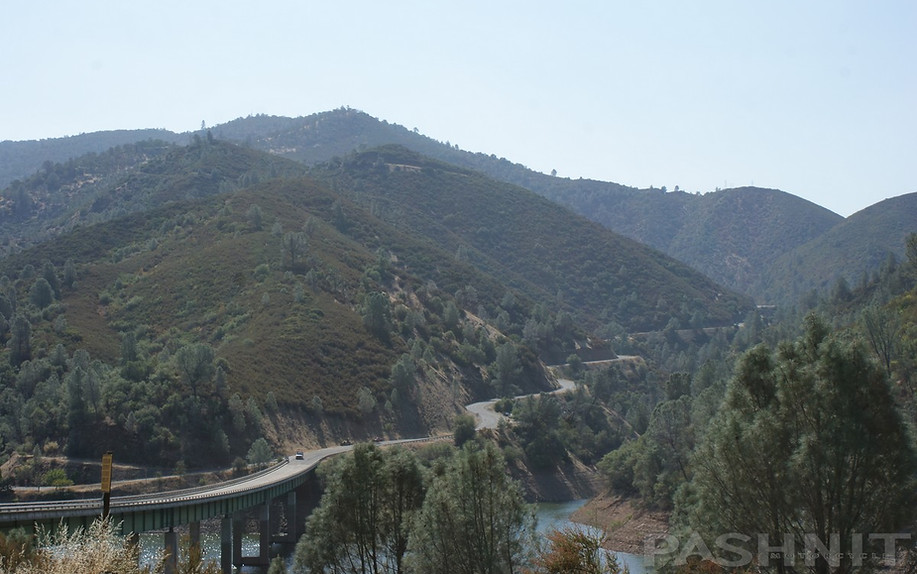
From the vista point near the 1,156 long 130 foot high bridge, completed in 1966. The site of Bagby lies east under, and sometimes exposed beside, the back waters of Lake McClure. Bagby's history passed through three definite developmental eras from 1850 to 1859. It was the site for Thomas E. Ridley's ferry. Then a dam and Fremont's water-powered stamp mills were built there, and the place renamed Benton Mills for his father-in-law. Later Benjamin A. Bagby built a hotel, store, saloon and boarding house on the north side of the river. When a Benton Mills Post Office was to be established on June 30, 1897, authorities found that a mining town in Mono County had a prior claim to the name. Applicant N.C. Ray, a mining man, promptly chose the title Bagby in the honor of his friend.
Site of Bagby, present day Lake McClure in a dry year when the Merced River returns to the valley
Bagby's subsequent history was integral with the importance of the Yosemite Valley Railroad. At its demise, Bagby had diminished to a fisherman's resort. When inundation threatened in the early 1960's, Yosemite officials arranged removal of a turntable, twin water towers, and the Bagby Station to the Yosemite Pioneer Transportation Center at El Portal. Bagby's remaining structures and old bridge were razed in late 1966. Where a stamp mill thundered and trains chugged, boaters now float. Among the first to launch a boat was B.A. Bagby's son, Everett.

In 119 years of recorded history, 2013 was the driest calendar year for the state of California and the valley was a dirty brown bathtub ring with the Merced River a mere trickle. Yet, all it takes is one winter to fill it back up and by January 2017 the rains came and filled the valley.
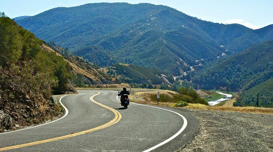
As quickly as the road descends to the valley floor, then crossing over a modern concrete bridge across the Merced River, it curses right back up the opposing ridgeline with a renewed veracity.
The climb south away from the Merced River is one of rapid-fire curves, consistent lean angles, a thrilling combination of hill climb goodness. A left then right, then do it all over again, a switchback, then head right back the other way smoothing around the hillside rapidly gaining in elevation as the Merced River slowly falls away into the canyon below. Any type of motorcycle, come one, come all will love this road. Half way up are some terrific views, but we’re not done yet.


What makes this ride so well-liked among motorcyclists are the wide-open spaces. Imagine if I could provide you an endless dose of curves, yet give you the see-through you've only dreamed about. Oh, and you'd like some brand-new pavement you say? Well yes, we have that too. This stretch of Highway 49 was also recently paved.
This segment of Highway 49 does all those things very well. The usual cautions apply on a tight ride like this, Autos overshooting the double yellow and a rare logging truck. Ah yes, the logging trucks. Something you might not think of is on the downhill diving around a tight corner and having a truck plodding on down the hill in front of you, engine brake on, doing half your speed. Might need to scrub some of your own rather quickly, be at the ready.
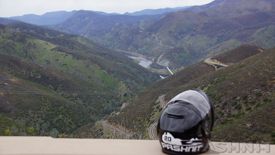
Once you reach the top of the hill on the Bear Valley side, a wide-open vista point, the Bear Valley Lookout, opens up often holding a few motorcyclists all taking in the view of the road they've just traversed, or are about to.

A required stop on your journey, the Bear Valley Lookout offers up the perfect picture taking opportunity. The sign at the top of the hill reads:
Fremont's Fort
General John C. Fremont, 1813-1890, a noted military man, explorer, topographer, Senator & businessman, Fremont was also a miner. He settled in Mariposa County living just outside of Bear Valley. He operated the Josephine, Pine Tree & Princeton Mines and other claims. In 1858 he returned from his travels to operate his mines and found many had been "jumped". In taking them back a feud developed with several groups, one being the "Hornitas League" which tried to seize one of his mines. After that incident a fort was built to defend the "only" access to the mines. Afterward his battles were in the courtroom.
The tiny town of Bear Valley is a short distance away from the southern vista point. John C. Fremont once owned all the surrounding land, purchased in 1858 for $3200. His ranch, La Marisposas Estate, spanned 44,386 acres. He sold it only a few years later in 1863 for $6 million. While Bear Valley once had 3000 residents, now the population is barely 120 people. Not much there except the Oso Hall Museum which we’ve never seen open or in operation- that's actually about it, and Bear Valley disappears within seconds in the mirrors.
Pashnit Tour groups often turn and head west here down the hill via Bear Valley Rd to Hornitos. This is a foothill ride that has fair bumpy pavement and endless foothill curves. At Hornitos, you can circle back around via Hornitos Rd, then turn back east onto Old Toll Rd for another twisty foothill ride. Some of this pavement is very poor. Just when you are cursing the tour guide’s (me) name, a brand-new stretch of pavement presents itself, and we get to be friends again. Lunch awaits at the 1911 Restaurant in the heart of Mariposa.
Back on Highway 49, after riding by the Mariposa-Yosemite Airport, which is often quite busy during fire season with large helicopters lined up on the runway for firefighting duties, Mariposa is a few easy miles to the south, and the first gasoline you'll come to if exploring the area and running dry. An eastward trek from here will take you up the river valley to Yosemite National Park.
Highway 49 only extends another 27 miles to Oakhurst and the southern entrance to Yosemite National Park via Highway 41. Bass Lake is nearby and The Pines Resort is our favorite place for lodging in the region. The Little Dragon portion of Highway 49 is short but definitely worth mentioning, or maybe turning around at the opposite end, and running it back the other way. Might just need another dosage.

Highway 49 Little Dragon - Photo Gallery


MORE INFO: Hwy 49 The Little Dragon
RIDE IT on a PASHNIT TOUR
15 Miles - LENGTH
Dreamy, Recently paved, Sandy in summer - PAVEMENT
Fast, several Hairpins, Smooth - CURVES
Coulterville to Bear Valley/Mt. Bullion - CONNECTS
Greeley Hill, Mariposa - GAS
Priest, Groveland, Mariposa- LODGING
1699 ft - Coulterville ELEVATION
2152 Ft - Bear Valley ELEVATION
The Little Dragon- MOUNTAIN PASS
GPS LOCATION
37°42′38″N 120°11′53″W - COULTERVILLE
37°30′26″N 120°02′42″W - BEAR VALLEY
NEARBY ROADS:
Highway 120
Marshes Creek Rd
Old Priest Grade
Priest Coulterville Rd
Greeley Hill Rd
Bear Valley Rd
Maps
