Coast Range Ride
Central Coast California
Santa Rosa Creek Rd
16 miles - LENGTH
Narrow paved backroad- PAVEMENT
Tight, sleeper, hairpin, steep, goat trail- CURVES
Cambria to Hwy 46 - CONNECTS
Cambria, Cayucos - GAS

Quick Ride: Paved backroad over the Coast Range, brilliant green hillsides in spring, Must-do if you love The Goat.

4 Goats on the Goat Scale
I warned him ahead of time.
This is a goat trail of epic proportions. He had never heard of the term. Goat Trail? Fit only for goats. I smiled. Doable, but take it easy on the Ducati. They were two up. He was a relaxed rider and no cause for worry, but still. Roads like this can be full of surprises, He nodded, and we were off. Onto one of the Central Coast’s most beloved backroads.
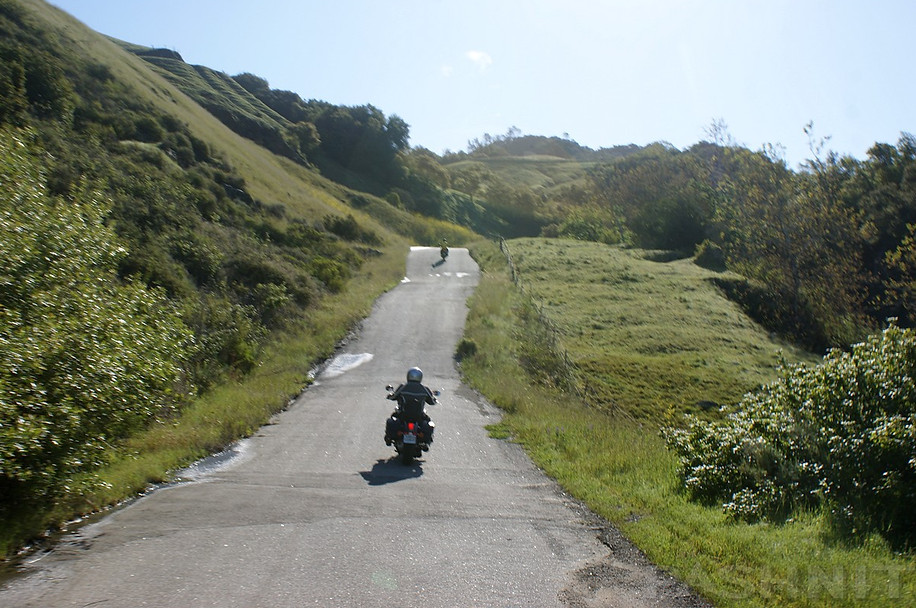
Never have figured out what attracts motorcyclists to roads like these: Bumpy, narrow, no center line. Typically deserted, the only paved road in the region. It was the classic example of goat.

Santa Rosa Creek Rd is found in the small town of Cambria along the Pacific Coast. South of Hearst Castle and the motel mecca of San Simeon, Santa Rosa Creek Road is tucked away in the southeast corner of Cambria.
It's well-marked if you have no map and just a general idea of where it might be. Ride on Main Street to the south end of town.
Cambria is always good for eats and fuel, as it's the first major gas stop along the southern fringe of the Big Sur Pacific Coastline for southbound riders. (Fuel is available at several places along Big Sur, but expensive.)
It's also home to a curious home on Nit Wit Ridge, visible on Main street at the corner of Main & Cornwall.


Built a piece at a time by junk hauler Arthur Harold Beal, he spent 51 years of his life creating the house from beer cans, old tire rims, bathtubs, toilet seats and a lot of concrete. The home was purchased in 1999 by Michael and Stacey O'Malley and gained inclusion as a state historic landmark. You can take a tour of the home, but call ahead. The home was put up for sale in 2019 for $420,000.
The Coast Union High School is the first thing you’ll see, and past the school, the road quality of Santa Rosa Creek is poor to passing. The road is one-lane-narrow at times, bumpy and crumbling. No one seems to care. Instead, Santa Rosa Creek on the north end of the Santa Lucia Mountain Range is a great example of what the coast mountains are like. Extremely green in winter, dry and hot during the summer, even this close to the Pacific. The color of the surrounding hillside changes dramatically, burnt brown in summer, and brilliant glowing green in spring.
From Cambria, the road heads up the Santa Rosa Creek valley, following the stream bed. Several farms and small vineyards line the road, enabling the sense that they've been there for decades. In the last few years, a few newcomers have established homesteads into this valley, clearing the hillsides for grape vines. So be mindful of opposing traffic.
Deeper into the valley, Santa Rosa Creek Rd rises and falls across a rolling landscape, then hides in a canopy of trees at times nudging its way along a small stream, which is often dry in summer.
A second glance looks as though in the height of winter, enough rain would flood this small stream bank and come right up onto the road in places. The further away from the ocean, the more the heat increases during summer.
There are several sleeper corners, and always the taunt of sand in the road, especially around driveways and the right-hander. Be especially watchful of those, where the shoulder is the same height as the pavement.
Vehicles cut the corners, in turn kicking up dust and sand onto the road. The straights will suck you in, the sudden corners will spit you out.


On occasion, someone in our Pashnit Tour groups will say the back end came loose in a corner. It can happen, and even be a bit scary as things get loose, then hooks up if you're too hot into a hard left or right-hander. We often respond that if you lose the backend on a road like this, you are taking the wrong line or going too fast for conditions. Choose your line carefully and expect the sand to be there.
I waited at the halfway point, before the big uphill climb, for my partner on the Ducati. Cutting their teeth on this narrow road, he rolled up to stop beside me, flipping up the front of his Shuberth helmet.
Goat Trail? I think this is 4 Goats on the Goat Scale. 4 being maximum, of course. I chuckled and chided him a bit. It fit.
'The Goat Scale' has become part of the Pashnit lexicon. California is chock-full of them, and we were riding atop its flagship.


If you're staring into the photo sequence above, you're looking at the highlight of Santa Rosa Creek Rd. The stream bed portion of Santa Road Creek Rd comes to an abrupt end and then the road climbs straight up. This steep uphill sequence is one of the most enjoyable sets of switchback curves for miles. It’s worth noting this dual set of switchbacks are unusually steep and tight. We insist on telling riders to not cut the corners on these switchbacks, swing wide to the outside and choose your gear carefully as you enter the corner.
One particular Pashnit Tour, our rider did not heed this warning in the day’s safety brief, proceeding to cut the left-hand corner and ride the very inside lane, the steepest part of the switchback and misjudged the gear. As he entered the corner, he was going too slow and simply fell over. Not a crash, but rather not enough revs or the right gear to ease around the corner, and he simply laid the bike down on the crash bars. Lesson learned. Don’t do that. Ride the outside lane.

The photos don't lie. The hills come alive in spring when dosed in a welcome coating of rain. Ride by April to see this amazing layer of color. By late May, the heat arrives and the color changes in a dramatic way. Find a good spot, park the bike alongside the road and take it all in. All the world seems a million miles away back in here. Possibly, that's why you are here.
Halfway up the hill climb is a Y in the road. Cypress Mountain Drive is a dirt fire road up and connects over the range covering just shy of 10 miles of dirt ranch road before you'll hit Chimney Rock Rd on the other side at Adelaida. Although Cypress Mountain is a one-lane ranch road, it has some broad views of the Santa Rosa Creek valley with the Pacific Ocean in the distance as it climbs to the crest of the Coast Range. The reward on the east side of the range arrives with portions of Chimney Rock Rd having been recently repaved with dreamy smooth pavement. Remote and deserted, this region on the east side of the Coast Range is all about producing wine. If one-lane dirt fire roads are not your thing, you can still easily access the other side of the range via Vineyard Drive from Highway 46.

Once through the switchback sequence deep within this valley, it is another 4 miles of flowing down off the ridgeline in a smooth and steady ride before you'll hit Highway 46. Cattle line the side of the road (and sometimes stand on the road) as the ride flows through a broad valley. Pavement improves, widens and smooths out here in this last quick sequence. Highway 46 is the main highway up and over the Coast Range to Atascadero or Paso Robles.

Ah, but what do my eyes spy directly across Highway 46? This is Old Creek Rd, and riders will commonly combine these two together to form a nice loop out and back to Hwy 1.
Old Creek Rd (pictured below) continues this twisty backroad ride into Cayucos and neighboring Morro Bay.
However, the tempo changes to a country backroad with a center line. It still can be a narrow bumpy ride, and you'll be loathing the day that any lumbering auto impedes your progress as the pavement is inviting, exciting and just plain fun.
Riders descend into the canyon, covered in trees, losing elevation, tossing back and forth, a fun spirited ride indeed. The smaller bikes such as the flick-able standards and your buddy on the DRZ will love this road.
Old Creek Rd is a fast ride with smooth pavement that flows across broad meadows broken by diving through tunnels of tree stands. A low summit pops up at the mid-point and then a rapid downhill on the southern half. The ride tightens up and curves become sharper in a quick succession of S-curves with several blind corners. It's here you'll be giggling like a school girl in that helmet of yours. Great fun!
Whale Rock Reservoir fills the view as you descend Old Creek Rd. Completed in 1961, this 40,000 acre-foot reservoir provides water for the City of San Luis Obispo, Cal Poly State University and California Men’s Colony and collects water from a 20 square mile watershed.
Old Creek Rd could be the poster child for California Motorcycle Roads. Quick, fast turns, elevation change, a whoopin' good time on two wheels. And worth the detour for north or south bound riders traveling along an otherwise boring section of Hwy 1 from Cayucos to Cambria. Old Creek Rd deposits you directly back onto Hwy 1 only 15 miles to the south of where you started in Cambria. It can be a quick in and out and well worth the detour. The loop itself of Santa Rosa Creek Rd and Old Creek Rd is a mere 26 miles. If you are headed inland from Cayucos, Old Creek Rd to Highway 46 is the way to go. Your only lament will be Old Creek Rd is way too short. But you will learn to love the goat. All 4 goats.

MORE INFO: Santa Rosa Creek & Old Creek Road
Northbound Riders:
After Morro Bay, you'll hit Cayucos and there's Old Creek Road. You may need to watch for it. The turnoff is a main intersection with a stoplight. First time I went looking for Old Creek Rd, I rode right past it, somehow stuck on the idea I was looking for some backroad turnoff, rather than one right in the middle of the town of Cayucos. Turn eastward and head on up the hill. The ride is uneventful until past the reservoir, then Old Creek Rd builds a crescendo of exciting curves and uphill climb.
Nearby Roads:
Eastward via Highway 46: Endless list of roads: Best option is Vineyard Dr > Peachy Canyon > Adelaida Rd > Chimney Rd > San Miguel Rd to San Miguel and gas. Further inland at Santa Margarita (at Highway 101) is Highway 58 & Highway 229. Also note Bitterwater Rd.
Northward: Ride Highway 1 Big Sur, also Nacimiento Rd, Carmel Valley Road, Highway 25, Los Gatos Road & Panoche Road. Hearst Castle is a few miles north of Cambria. Lonoak Rd is found at King City.
Southward: At Highway 166- Tepusquet Rd over to Foxen Canyon to Solvang. Want a nearby goat trail? Try Turri Rd & See Canyon outside Morro Bay.


MORE RIDER INPUT:
Santa Rosa Creek Road starts at the south end of Cambria. It stays at the lower elevation for a little while as it follows Santa Rosa Creek. Hence, the name of the road. Anywhere there's a creek or river, thick trees and shrubs abound. And this was so in SRCR. The turns were all slow. The road is narrow and bumpy. But the scenery was so pleasant that we forgot about speed. I was constantly in 2nd gear. Sometimes 1st gear so I wouldn't miss the surrounding scenery.
We passed by country homes looking like they were straight out of a movie or a magazine like House & Garden. Many of the homes had wind chimes hanging on their front porches, just like I imagined a country home would be. I could live here and write poetry and books for the rest of my life and be perfectly happy.
We approached a small turn-off by the creek and decided to stop and take some pictures. While admiring the view surrounding us, a few bicyclists passed us waving and smiling. In addition, a couple of cagers passed by waving and smiling too. How could they not? It was so pleasant just being there that morning. I loved being out there. I could travel like that forever and never have a complaint. It also amazed us that California still had places such as these. It made us happy that it existed.
The ride through the valley floor ended, and we were soon climbing up to altitude. There were a couple of 180 degree turns that I wasn't anticipating, so I had left the Busa in 2nd when I should have been in 1st. Oh well.
The bike almost stalled, but I managed to keep it under power. At the top of SRCR, we could see the Pacific Ocean below. Many Moto-magazines have taken pictures of test bikes with that view in the background. The descent back down from the top of the hills wasn't as steep as the ascent. It was in fact, quite gradual. And here, we were able to pick up speed since many of the turns had good visibility on exit, as well as being less bumpy. The road even managed to give have a nice camber to maximize traction and ground clearance. Nice.
-Jordon Marcello, aka Rogue Biker
Suzuki Hayabusa GSX1300R

Santa Rosa Creek - Old Creek Rd - Photo Gallery


MORE INFO: Santa Rosa Creek & Old Creek Road
RIDE IT on a PASHNIT TOUR
16 Miles, 26 combined Old Creek Rd - LENGTH
Poor, Tight, Sandy, Sleeper Corners - PAVEMENT
Creek bed road, tight hairpins, steep climb- CURVES
Cambria to Hwy 46 - CONNECTS
Cambria - GAS
Cambria - LODGING
0 to 1900 Ft- PEAK ELEVATION
Rides over Coast Range - MOUNTAIN PASS
5°33′15″N 121°5′15″W - GPS LOCATION
Cypress Mountain (dirt) - LISTED SIDEROADS
Maps

