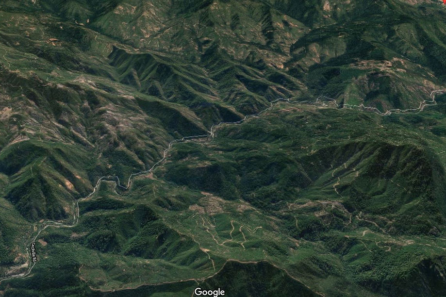
Somes Bar to Etna or Callahan (63)
Northern California
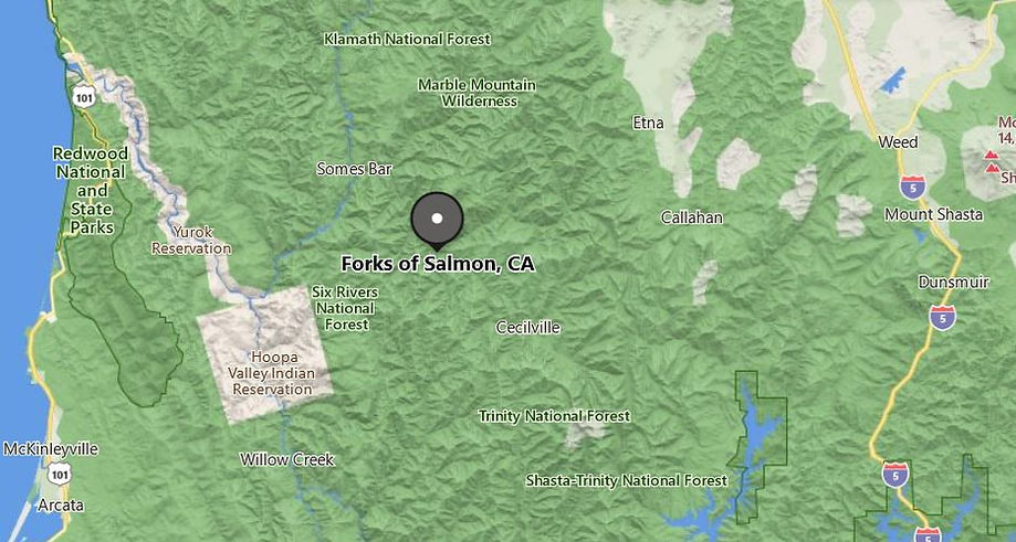
Forks of Salmon

Salmon River, Sawyers Bar, Cecilville Rd
60 or 65 Miles - LENGTH
Fast sections, narrow single lane, mountain road - PAVEMENT
Smooth, fast, tight, single lane blind, - CURVES
Highway 96 to Etna or Callahan at Highway 3 - CONNECTS
Orleans, Cecilville, Etna - GAS

HIGHLIGHTS
Somes Bar
Forks of Salmon
Sawyers Bar Rd
The Multiple Personality Road
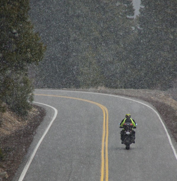
Which personality should we start with? The two mountain summits, the racetrack portions, the Bolivian Death Road portion, or the multiple times we’ve gotten snowed on while riding this. Throw in truckers who believe their GPS over common sense despite the huge sign at the west end that shouts, ‘Your GPS is wrong!’
This is a much-loved motorcycle road with multiple personalities. The more personality you get to know, you more you want to spend as much time with each persona. Multiple personality roads are a delight. Changing themes in an instant and throwing out stretches of pavement you have to see to believe. The Forks of Salmon ride is just that, never holding on to any one theme for very long, rather, it offers up all of them in one delightful ride. The fast twisty section, the mountain summits, the single lane with steep canyon drop-off, the mountain river. And in the middle of it all is a sign that advises you’re entering a congested area, Forks of Salmon, pop 133. Always brings a chuckle.

This road splits in the middle, thus the fork. Sawyers Bar Rd heads northeast to Etna. Cecilville Rd heads southeast through Cecilville to Callahan on Highway 3. Forks of Salmon begins at Highway 96 and the entire ride may easily be described as the middle of nowhere. The Marble Mountain Wilderness lies to the north, and the Trinity Alps lies to the South. Sandwiched in between these two mountain wilderness regions is the Salmon River Valley.
For the sake of simplicity, let’s ride this eastbound from Highway 96 near Somes Bar towards Highway 3. It’s worth noting right out the gate that NONE of this road is appropriate for large vehicles, or those pulling trailers. While that may seem wildly obvious to the most simple-minded person, it’s worth mentioning any time this road comes up in conversation. As for motorcyclists, this is an awesome road, super fun and delightfully different.

Fuel
Gas stops and fuel range should always be considered when wandering around the mountains in Northern California. While there is fuel in strategic locations, there is none when you’ll need it most. There are about three locations for fuel in a broad region of about 100 miles in diameter: Etna, Cecilville & Orleans. But everything near, and along this ride, is labeled as wilderness. There is a 24-hr cardlock fuel station in Cecilville with an above-ground tank, but none at Somes Bar on the western terminus, and none at Callahan on the east end. If you are headed south at Callahan, there is no fuel until Weaverville along Highway 3. There is fuel in Etna on the east end of the northern leg. The closest fuel on the west end would be Orleans, 7 miles to the southwest along Highway 96.
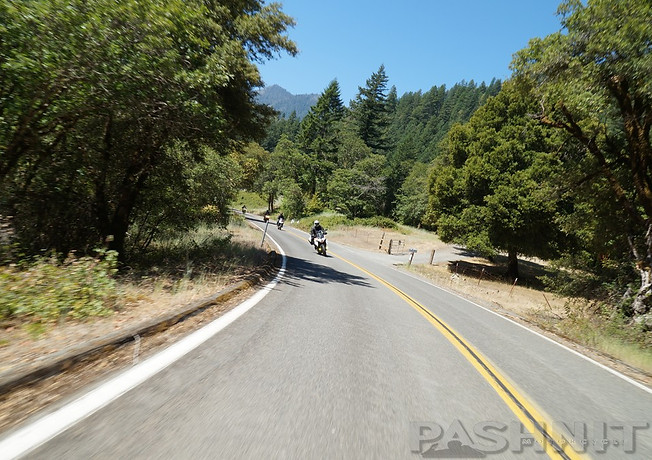
The surprising part about Forks of Salmon is how fun the road is on the western side following the contours of the Salmon River for the first 7 miles, known as Salmon River Rd, the road here wiggles along the contours of the river occasionally swapping sides.


Super fun ride + wide open vistas of the Salmon River for the first 7 miles of this ride
Somes Bar is located two miles from Highway 96 above the mouth of the Salmon River. Various accounts say that this mining camp, dating from the 1850s, was named for a settler, Abraham Somes or George Somes. The name is shown on the Land Office map of 1879 as Some's Bar, and the Mining Bureau map of 1891 as Sumner's Bar. The post office was listed as Somesbar after 1892. It thrived for 40 years but was eventually abandoned.
There is no shortage of fast corners and several sleeper corners that have surprised riders on Pashnit Tours, although this S-corner is marked as 15 mph. It’s in your best interest to pay attention to those signs. For all the talk of narrow single lane stretches this road is famous for, this is not that place. The first 7 miles are two lanes with a centerline with fair pavement, inviting frivolity and glee. There are some pullouts and short straights along the river to allow a quick shimmy past slower traffic. Give a wave and motor on by the locals.
Rapids along the Salmon River call out to kayakers, and you may see people in wetsuits preparing for the cold mountain water at numerous river access points. Numerous side roads spider away from the river with names like Brannon’s Bar, Oak Bottom & Three Dollar Bar. Otter Bar Lodge is a small resort along the river that caters to kayakers.
The Salmon River wiggles left, then right. Every curve in the river forms what is known as a bar, a flat expanse of gravel on the inside of the corner as the fast-moving water slowly carves out the corner, leaving a deposit of gravel behind on the inside of the bend in the river. Gold miners quickly discovered these expanses of flat gravel often contained gold and these were quickly mined first- and each one named.
Every bend in the river gained a title, Somes Bar, Three Dollar Bar, Knudsen Bar, Otter Bar, Fong Wah Bar. Every ravine and adjacent creek were also named by miners, Wilson Gulch, Murderers Gulch, Sauerkraut Gulch, Applesauce Gulch, Logan Gulch, Dead Mule Gulch, and more. Over a million ounces of gold was removed from the Salmon River Valley, worth over $1B in today’s dollars, yes, with a B. The Salmon River quickly became the richest gold-producing region in Siskiyou County.

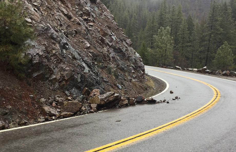
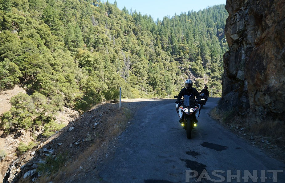
At the Butler Creek River Access is a small caution sign: Narrow, Winding Road Next 35 Miles. This last stretch of road from Somes Bar to Forks of Salmon was completed in 1925. There’s a small turn-around here along with a public vault toilet. The next 10 miles to Forks of Salmon is all single lane. Wandering along the river through tree tunnels and sometimes along sheer rock cliffs. The drop-offs begin here and, at first, are a bit unnerving. There are few guard rails anywhere and at the right spot, you can see straight down into the river below.
Through the years, occasional rock slides have occurred, and the cliff face is collapsing onto the road. However, people live out here and the road never stays closed very long. Siskiyou County rushes to the site of the rock slide and clears the obstruction. But this also means to be at the ready and aware of rocks in the road.
The elevation only climbs about 600 ft from Highway 96 to Forks of Salmon, so there are no rapid elevation changes, no switchbacks, only a steady imperceptible climb into the mountains.
In the s-curves, there are often open views of the road ahead, and you can see if any traffic is coming towards you on this single-lane road, however, there are also numerous blind corners, and it’s best to always be at the ready and in the right lane position in the case of opposing traffic is headed straight for you in a blind corner.
In several sections, the cliff edge into the canyon is frequently inches away, with zero shoulders along the stretch into Forks of Salmon. One might assume this is a temporary thing, but on the contrary, this single-lane goes for miles and continues on both forks, but is most pronounced on the Cecilville Rd portion. It’s also the highlight of the ride.


Moss clings to the rock face along the road, providing an aura of greenery in winter and spring months, but the opposite is also true in late summer, when these canyons are layered in stagnant hot air with nowhere to go. Riding in 90 degree temps in the heart of summer would not be unusual.
There are stretches of the one-lane section into Forks of Salmon that have an ethereal quality to them. As in, this can’t be real. I’m on a single lane rural remote mountain road in the middle of the wilderness with few people, no towns. The sheer rock walls, the moss, the tree tunnels, the single lane, it’s a unique ride.

Nordheimer Campground is 12 miles from Highway 96 along this stretch and located on an open flat along the road. There are approximately 12 single sites and 4 group sites. Individual sites first-come, first-served here, but it’s worth noting the campground can generate vehicles pulling campers on this very narrow road. The sites are generally open from May through October.
A wide, expansive meadow introduces Forks of Salmon along with a tiny school. Forks of Salmon is literal, two rivers join here, the North Fork and South Fork of the Salmon River. In the present day, there’s nothing here other than a small school situated along the banks of the Salmon River, deemed remote rural, with just 9 students for K-8th grade. Beyond the elementary school is a tiny pioneer cemetery.
Forks of Salmon
As you near what technically is the town center, our favorite sign appears, Congested Area. Bear in mind, this is a single-lane road. There’s an old barn here with a hand-carved salmon plaque on the side, situated on an s-curve that’s always full of tiny pebbles and necessitates a slow entry. Nearby is an old gas pump, vintage 1980s, that I would have to assume was the location of a general store that operated here in the 1950s.
Once through the s-curve, you’ve ridden through the entire town, albeit congested. Beyond the ‘city center’ 100 yards is a bridge over the Salmon River. Continuing due east, the ride becomes Sawyers Bar Rd, but heading south across the bridge provides entry onto Cecilville Rd.

Both roads have substantial single-lane portions, but the section we call the Bolivian Death Road is the southern leg deemed Cecilville Rd to Cecilville. If sheer drop-offs into the canyon below plus blind corners on one-lane roads are not your cup of tea, it may be best to skip this ride.
Forks of Salmon as the center of this ride dates as far back as one of the earliest mining sites beginning in 1850. The confluence of the two branches of the Salmon River became an important supply center. The flow of miners supported a two-story hotel, bars, and a general store. A sawmill was built at the Forks of Salmon, and another sawmill was built 6 miles upstream at Methodist Creek (at FR 39N04) along the Cecilville Rd portion.
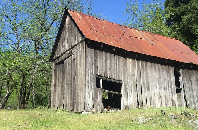
Old barn in Forks of Salmon
By 1858, a post office was established here to service the gold miners. The North Fork of the Salmon River alone produced over 1M troy ounces of gold, at $1500 per ounce at current value, that’s over $1B in gold came out of this valley adjusted for inflation. The Salmon River Valley quickly became one of the biggest gold strikes in American history.
Hydraulic mining was practiced here also. Hydraulic mining involves using high pressure water hoses to blast away hillsides to reach the gold hidden in the layers of placer.
The practice had been outlawed in the first piece of environmental protection law ever passed in California in 1884, but Siskiyou County seems to not have paid any attention to the ruling affecting the Sierra Nevada Foothills.
The Sacramento Union newspaper in 1914 published this announcement:
1914 December 28, Sacramento Union - PREPARING TO HYDRAULIC - The Bonally hydraulic mine near the Forks of Salmon is working a large crew of miners. The company has just finished putting in a lot of new fluming preparatory to the coming water season. The company has already piped off all the surface dirt for the coming season and will be working on their large deposit of rich gravel during the spring and summer months. This is one of the big hydraulic mines of western Siskiyou and has yielded many thousands of dollars in the past few years.
By 1860, the rich surface and river placers were largely exhausted, and hydraulic mining became the predominant method of mining for the next 20 years. Much like in the Sierra Nevada Range, hydraulic mining had the same destructive results. Hydraulic mining was finally prohibited on the Klamath River and its tributaries from July through November in 1936 by the Quinn Bill.

However, when the gold dried up, the miners left for the next strike, and little evidence remains. Both gold and platinum were mined in the region but you won’t see any gold mining activity along the ride. Even the practice of suction mining was outlawed in 2009.
At the bridge over the Salmon River is also a nearby tiny building serving at the town post office, unmanned. There’s an equally tiny park/rest area here comprised of several picnic tables along the river with a vault toilet, and on previous visits, a working wired public phone.
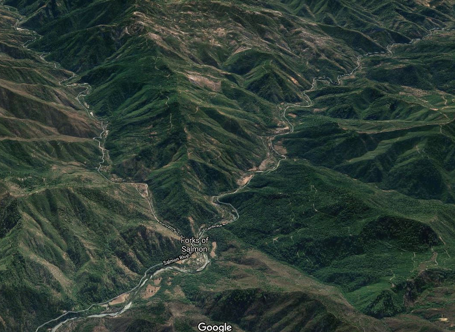
Don’t count on your cell phone working in these mountain valleys. The road splits here into the two forks (thus the name), both following the two main branches of the Salmon River. The elevation of the river is around 1200 ft at Forks of Salmon. There are two options at Forks of Salmon, Sawyers Bar Rd continues up the canyon then climbs over the 6000 ft Etna Summit into Etna. The southern leg is Cecilville Rd through the even more tiny mountain community of Cecilville.
But the Cecilville-Callahan Rd section has the stretch we simply call The Racetrack. Which direction you take depends on your plans, can’t say one is better than the other, but The Racetrack portion is loved by all riders and will leave you beside yourself with wonderment as to how a road like this could even exist.

Post Office in Forks of Salmon, CA
Forks of Salmon to Etna via Sawyers Bar Rd
40 miles to Etna
Sawyers Bar Rd follows the northern leg of the Salmon River through the tiny mountain community of Sawyers Bar, 15 miles away from Forks of Salmon and connects over Etna Mountain. A road was not built over Etna Mountain until the 1890s, when the constant flow of gold miners finally necessitated a crude dirt road. Gradual improvements over Etna Mountain expanded into an enjoyable two-lane. The region around Sawyers Bar was never improved beyond basic paving and is still single-lane. The first vehicle over the summit was a Ford Model T in 1910, driven over Etna Summit in reverse, since it was the strongest gear. The segment of road from Forks of Salmon to Sawyers Bar was completed around 1937. Not much has changed. The Sawyers Bar leg is 40 miles to Etna, and the Cecilville leg to Callahan is 48 miles from Forks of Salmon.

Sawyers Bar Rd from Forks of Salmon to Etna on the North Fork Salmon River - Majority of this stretch is single lane
Sawyers Bar Rd still retains the same narrow one-lane motif, with several sections of sheer drop-offs into the river canyon while wiggling left and right. More broad vistas open up in spots, and your brain will surely marvel at the mountain majesty of it all. There are several private homes in the Sawyers Bar section, while there were almost none in the run-up to Forks of Salmon, plus more blind corners along your new favorite single lane mountain road.
One domicile, in particular, is on the opposite side of the river and appears only accessible from a suspension bridge wide enough for walking across. I counted at least two of these suspension bridges at two different locations across the river, near Murderers Gulch and Dead Horse Gulch. A land-locked property with no means to reach via a vehicle. Not sure if I could sell my wife on that house.


Further mounds of tailings are visible around the corner at Dead Horse Gulch signaling what appears to be gold mining operations are also on the other side of the river. The Salmon River Gold Mine may be active on the south side of the river processing placers from along the river bed. There’s no vehicular bridge so let’s assume all bulldozers and excavators were driven through the river rather than across. The road is still a single lane so if you’re curious, you may need to hunt for a place to pull over to get a view of the operations on the other side of the river.
Sawyers Bar
A tiny collection of homes labeled as Bestville on some maps signals the entrance into Sawyers Bar. The tiny mountain community of Salmon River was named for Captain Best, who in 1850 led the first party of prospectors into this wilderness area. A small town grew centered around the gold miners at Sawyers Bar. In 1964, an arson fire in Sawyers Bar takes most of the historic buildings in the center of town and they are never rebuilt.
The only business that pops up claiming Sawyers Bar as home is the McBroom & Co. Packers & Guides. In 1847 the McBroom forefathers were the first settlers in the rugged Salmon River canyon. To accommodate the needs of successive settlers, the McBrooms provided a packing service, as in pack animals and mountain trail guides. 175 years later, they’re still in operation. If you’re looking for a back-country guide, be sure and click the link below. You’ll know by the horses, who sometimes are standing in the middle of the road.
At the Sawyers Bar Town Hall, a plaque placed beside the road reads:
Sawyers Bar is perhaps the most picturesque of the northern mining towns. It was founded in 1850 by Captain John Best and party who were guided to the spot by a friendly Indian.The town was originally called Bestville and had over 3,000 inhabitants. It owes its present name to the fact that on an adjacent gravel bar stood the camp of early day mill sawyers. The most noteworthy features are the century old frame buildings and the famous Catholic Church, counterpart of the southern mission.The towns (sic) first postmaster was John Daggett who in 1883 became Lt. Governor of California.
The road becomes progressively narrower as it rides through Sawyers Bar. Sawyers Bar was named in the 1850s for Dan Sawyer, who lived and mined near the site of the present town. Later the name was applied to the settlement recorded on the von Leicht-Craven map of 1874. In the present day, a few houses are still positioned not feet, but mere inches from the single-lane road. The speed limit in town is 15 mph, and that seems entirely appropriate. The population is estimated at 200 people, although that seems optimistic.


Sawyers Bar Catholic Church
Sawyers Bar served as a hub to other bustling mining settlements up and down the Salmon River and tributary creeks. A road was not built over Etna Summit until the 1892, completed in 1899. Prior to 1899, the gold mining settlement were only reached via walking with your pack animals over the range to reach Salmon River Canyon. Dan Davis, Sawyer’s Bar’s first blacksmith, sharpened picks on a big rock he used as an anvil, charging $1 per point.
Sawyers Bar Catholic Church
At the Salmon River Restoration Council & Watershed Center on the west end of town, there is a tiny historic Catholic Church here on the east side of the center. There’s a barely noticeable sign denoting the building up above the road. The church was built in 1855 under the direction of Father Florian Schwenninger, a Benedictine monk, who had come to the area of the Salmon River to serve the needs of the Catholic population among the local miners. A devout man, he brought with him a painting of Christ’s crucifixion
Father Florian is reputed to have built the altar himself, and the first Mass was celebrated in 1857. Made from whip-sawn lumber in 1855, the church is the only original structure remaining in Sawyers Bar today and one of the oldest structures on the Salmon River. Unable to procure ornate stained glass in such a remote location, Father Swenninger made up for it by placing his ornate painting of the crucifixion above the altar. That painting remained in the church until 1980 when it was moved to Fort Jones. The site also contains a graveyard with pioneer headstones dating as early as 1850. The Sawyers Bar Catholic Church was added to the National Register of Historic Places in 1978. The historic site is easy to miss if you didn't know it was there. It’s regarded as the oldest remaining Gold Rush Catholic Church built in a national forest, and the oldest Catholic Church in Northern California. The ground under the church is still regarded as the richest piece of land in the town, as it’s the only ground in Sawyers Bar that has not been mined for gold.
Black Bear Commune
Peter Coyote is an actor known for E.T. the Extra-Terrestrial (1982) as Keys, Outrageous Fortune (1987) as Michael Sanders, Sphere (1998) as Captain Harold C. Barnes, Erin Brockovich (2000) as Kurt Potter, and a hundred plus other movies. He was also a local resident of the local commune in the late 1960s.
Black Bear Ranch is 9 miles southwest of Sawyers Bar in Marley Gulch (named after Richard Marley, one of the commune's founding members) via Eddy Gulch Rd at the end of a dead-end mountain road. Originally, a gold mining settlement in the 1860s that had produced $3,000,000 in gold by 1883, the main house is a relic the commune inherited from over a century ago when Black Bear Ranch was one of the more prosperous gold mines in California. Over 25,000 feet of tunnels, shafts, crosscuts, and raises had been dug to extract gold embedded in quartz rock with a 32-stamp mill. John Daggett, the mine owner in 1883, even propelled himself into politics as the state’s lieutenant governor.
The 80-acre property was sold in 1966 by the Dysert Family to a San Francisco man and his ‘large family’ for $22,500. Some of the funds were sourced from musicians who were solicited, such as Frank Zappa and The Monkees, to contribute funds to purchase the property. Black Bear Ranch would go on to be one of the numerous communes in the late 1960s, known colloquially as an intentional community. Black Bear Ranch gained an air of infamy after being the subject of the 2005 documentary Commune, (watch it on YouTube). Peter Coyote, once lived there. Black Bear Ranch is still an active commune over half a century later and has stayed active since it was established in 1968.
Also, due south of Sawyers Bar is Cecilville located 21 miles to the south via a dirt mountain road, Eddy Gulch Rd.
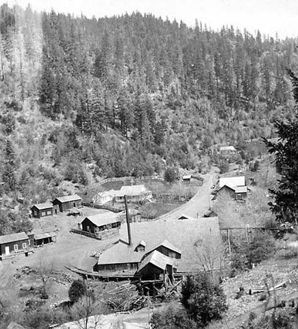
Black Bear Gold Mine active 1860-1883 produced $3,000,000 in gold from 240,000 tons of ore.

Sawyers Bar, California
In any other circumstance, Sawyers Bar Rd as a single-lane mountain road should weave into the mountains and then simply stop. As in stop, no more pavement, no more road. Ending up on some remote clearing on a mountain top. But that doesn’t happen. This road goes someplace, with purpose, and deliberate intent.
Surprisingly, Sawyers Bar Rd eventually graduates to a normal dual-lane as the climb up to the summit begins, headed through two switchbacks up the mountainside gaining rapidly in elevation. Sawyers Bar Rd finally breaks away from the North Fork of the Salmon River at Idlewild Campground and flows along North Russian Creek. The single lane is finally over after 43 miles of following the edge of the Salmon River. At the second switchback, the two-lane starts.
The climb to the summit is fast, fun, and full of smile-inducing lean angles, climbing from 3600’ to 6000’. The tall peak directly west is 7044’ Yellow Dog Peak along with a stunning view of the Klamath National Forest.
At the 5950’ Etna Summit is access to the Pacific Crest Trail, which crosses the road here. The Pacific Crest Trail flows north-south along the tops of the ridgelines until it finally reaches the Grider Creek Canyon and pops out of the Marble Mountain Wilderness at Seiad Valley along Highway 96 then continuing north into Oregon nearing Ashland and meeting up with Interstate 5 at the summit.


Pashnit Tour group atop 5950' Etna Summit
The last 10 miles from Etna Summit into Etna are all gravy. A smooth, fast drop off the mountain and coasting the rest of the way into Etna. Etna was originally named Rough and Ready, but was changed by statute in 1874 to the more conventional name of the nearby flour mill (spelled Aetna).
Etna is small at about 700 people, but it has a high school, fuel and eats. If it’s time for lunch, stop by Bob’s Ranch House Restaurant. We’ve used the Bob’s Ranch House Restaurant as the halfway point of our day. You can expect hearty American food on the menu. I love to order breakfast for lunch here.

First stage over Etna Mountain on the newly completed road in 1891.

Forks of Salmon to Callahan via Cecilville Rd
47 miles to Callahan
The road from Forks of Salmon to Cecilville was completed in the 1950s. Not much seems to have changed since then and Cecilville Rd continues the motif of single-lane mountain road with sudden and steep drop-offs. There are numerous places where there are zero shoulders, in addition to a sheer drop-off into the canyon along this single-lane mountain road. Cecilville Rd clings to the contours of the South Fork of the Salmon River along the base of Salmon Ridge to the south. However, Cecilville is at an elevation of 2360’ meaning a steady climb in elevation without any rapid or sudden elevation changes that involve steep climbs or switchbacks.
Cecilville Road

Two forest service campgrounds along this stretch can mean vehicles pulling campers although certainly not advised on the one-lane road. Hotelling Campground has four sites right on the river, and Mathews Creek Campground further upstream has 10 sites.
During the 1970s, Whitewater kayakers discovered the Salmon River as a place to run rapids and with a bit of advance planning, you too can run the numerous sets of rapids plus base at these campgrounds situated right on the river.
The Salmon River in the canyon below flows with the seasons, fast during spring snowmelt, and slowing down to a trickle in the heat of late summer.


Click L/R Slider to view Cecilville Rd
Much like the Sawyers Bar portion, there are numerous places where the road pops out of the heavy tree cover into the canyon and reveals a broad open vista of rugged mountainous ridgelines. A stop somewhere along the Cecilville Rd portion is a necessity to breathe the mountain air and listen to the south of the river.
My favorite activity is to climb down to the river and stand in the middle of it and imagine never leaving.
Maybe the guy with the suspension bridge across the river is on to something.


Cecilville
Cecilville marks the halfway point on the Forks of Salmon to Callahan leg of this journey. Cecilville is a tiny mountain community located on a broad natural flat area nestled in a mountain valley near the junction of the East and South Forks of the Salmon River.
Only a few people live here, and the last population count reportedly dates to the 1980s at 15 people. Cecilville was originally called Brownsville and functioned as a stagecoach stop. The natural flat regions were planted in alfalfa to provide hay for horses and cattle. The settlement was originally named for John Baker Sissel, who came to Shasta Valley sometime before 1849. The name was misspelled on Goddard’s Map of 1857 and again when the post office was established in June 1879.
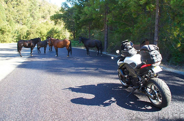
Arriving in Cecilville, theres's been horses in the road every time we've been here
Gold was discovered here in 1849 by James Abrams, and the region soon became an important mining district with a population of several thousand persons. Later, from 3,000 to 5,000 Chinese were reported to have worked the Salmon River utilizing flumes and wing dams. Substantial amounts of lode gold have been recovered in the district, the most notable source having been the King Solomon mine, which was most active in the 1930s and produced gold and manganese.
Discovered in the 1890s by Harvey Bowerman of Maine, the King Solomon Mine, located at the head of Matthews Creek on the South Salmon River, became one of Northern California’s major gold producers. Bowerman sought to process the gold ore, hauling in equipment, including three two-stamp batteries, a mill, boiler, a small steam engine, and a trolley car to carry ore to his mill. The King Solomon Mine was sold in 1900 and another $250,000 was invested in improving the gold production.
Eventually, over 1 million tons of gold ore was processed, and a company town sprang up along Matthews Creek to provide a workforce for the mine. Former President Herbert Hoover is said to have toured the mine. The King Solomon Mine site is located a few miles to the northwest of Cecilville via dirt mountain roads. WWII closed many gold mines in California, deemed not essential to the war economy of the early 1940s, including The King Solomon.

California's Cecilville Mining District included 44 nearby mines—9 occurrences, 1 prospect, and 34 producers, surrounded by mountain wilderness on all sides, and sandwiched between the Russian, Trinity, and Marble Wilderness regions.
Speaking of horses, there are no fences here and as mentioned, you’ll often find horses standing in the middle of the road. Other times while fueling up our tour group at the above-ground fuel tank, the horses have wandered over out of curiosity, seeking attention and appreciating being stroked and petted. At the fuel station is also the Salmon River Saloon. Admittedly, I have never seen it open while we’ve ridden through this community, but also never have I paid attention to their hours.

There used to be a big disc golf tournament here, but covid shut down many of these small-town activities. Designed by PDGA Hall of Famer Tom Schot, The Salmon River Disc Golf Course was completed in the spring of 2014. The course features 18 holes set in and around Cecilville with DGA Mach X Baskets and cement tee pads. Maybe someday, things will get back to normal. The last time the tournament appears to have occurred was in 2018.
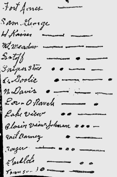
Cecilville is also famous for having one of the last magneto crank telephone systems in the United States. The telephone system here was originally a single strand of wire strung tree-to-tree over 37 miles of mountain wilderness to reach the outside world. This type of phone system is not powered by electricity, but rather by turning a hand crank to generate current to power the phone. Functioning as a 16-party line, the single-strand phone line pre-dates electricity arriving in Cecilville.
Magneto Crank Telephones
If you don't know what a magneto crank telephone is, it's technology that dates to the 1920s. With a magneto crank telephone, talking power is supplied by two dry-cell batteries on the customers end. Callers create a signal by turning a hand crank on a telephone. The list below is the phone book for Cecilville dated to the 1980s. Forks of Salmon and Sawyers Bar had a similar looking list until the mid-1970s. Different combinations of rings, such as long-long, or short-long-short rang respective homes on the 16-party line.
Major telephone upgrades had been made in the Salmon River regions, including a 1960 switch to microwave relay system to carry phone service from Sawyers Bar to Fort Jones to Eddy Gulch. Direct dial numbers were not possible until 1974 in the Salmon River region. Cecilville was the very last community to be upgraded, as its magneto phone system was still being used into the mid-1980s, and is regarded as the last operational magneto crank telephone system in the United States.
As of 2017, according to the Cecilville Saloon proprietor, Monk, two ranches are still using the old single wire and crank telephone system. The line is said to be 5 miles long, no switchboard needed, and it connects to the main line repeater the community uses for phone service.
Originally inhabited by the native tribe called Konemihu, Cecilville was settled by miners in the late 1800s. The original town was a stage stop called Brownsville and was located on the flat which now holds the back nine of the Salmon River Disc Golf Course and the community farm. The flats and the opening up of the river canyon made this area a natural place to settle. In the mining days, hay was grown here and horses and cattle were kept here.
The Bennet Resort was the original commercial venture on the property where the Salmon River Saloon now stands, opening in the 1960s, which became Snipes Villa in the late 1970s when Joe and Eileen Snipes bought the property which they operated until selling it to Jim and Leni Doyle in 1997 who renamed it Doyle's Camp. Monkey and Allegra bought the Cecil property in the spring of 2012 and added the above ground fuel station.
The Salmon River Saloon, Cecilville Station and the Salmon River Disc Golf Course opened in 2014. Cecilville General Store, a kitchen and lodging are said to be in the works.
There is a dirt mountain road here that connects to Sawyers Bar due north. It’s marked as Crawford Creek Rd here in Cecilville, but the map labels it as Eddy Creek Rd. It connects north over Black Bear Summit to Sawyers Bar 21 miles distnct via a dirt mountain road.
The handwritten phone book for Cecilville dated to the 1980s.

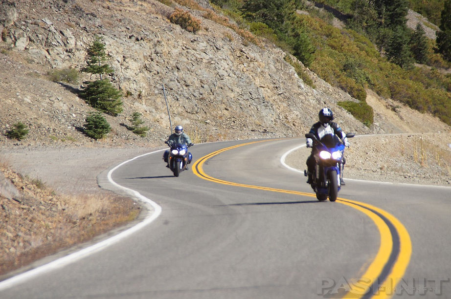
The Racetrack
The section of road from Cecilville to Callahan is the stretch we simply call ‘The Racetrack’. It’s not a race, and it’s not a track, but when you finally ride it, you’ll quickly see exactly why we call it that. Every motorcyclist has the same reaction every time.
What is this doing here? Why was this road built? Can we do that again?
And you would never know this perfect stretch of road exists if someone hadn’t told you about it. Even if you have no intention of riding the full length of the Forks of Salmon and your general direction is north/south along Highway 3, you may want to consider building this road into your journey. Ride 30 miles up, turn around at Cecilville and 30 miles back to Callahan. We call Northern California a Motorcyclist’s Paradise, but nowhere is this more evident than right here at The Racetrack. The best part is you’ve ridden by it multiple times and never knew it was there, till now.
While we call this portion The Racetrack, you shouldn’t race on it. We call the single lane portions of the Forks of Salmon ride the Bolivian Death Road, but it’s nowhere near Bolivia. Those two designations are quite the opposite, which provides the Forks of Salmon ride its mystique. And the tremendous dichotomy of being so different.
Northern California is known for a lot of amazing motorcycle roads. We regard this mountainous region as a paradise for bikers. A combination of remoteness coupled with small rural towns, endless mountains, and endless curves coalesce into a place that leaves our riders in awe.
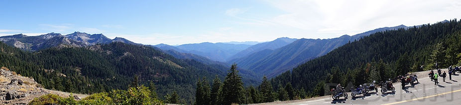
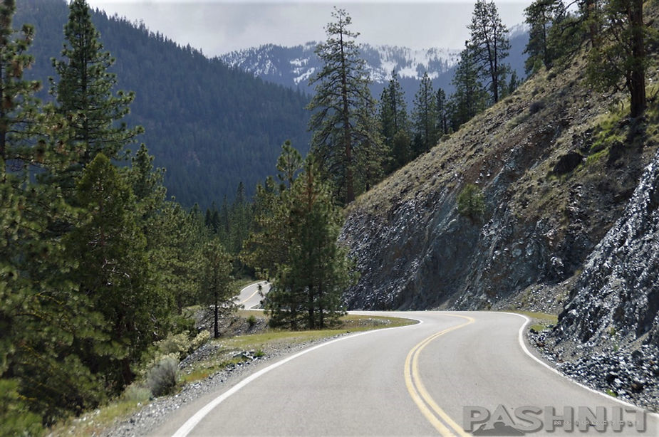
The Racetrack is one of the most perfectly built, well-engineered motorcycle roads in the state of California. There is zero traffic on it, zero guard rails, zero points of interest, and the perfect tempo of curves and mountain views. The ride is only 12-miles from Callahan to the 6100 ft Carter Summit, the highest elevation along this ride, but a total of 30 miles of bliss to reach Cecilville where the two-lane ends.
The Pacific Crest Trail crosses the road here at Carter Summit and continues north to Etna Summit. There’s a small parking area here at Carter Summit, and it's well worth a planned stop. My motorcycle tour groups have gotten caught in snow flurries multiple times at Carter Summit, a few times in white-out conditions. However, the solution is always to set off and simply drop in elevation.

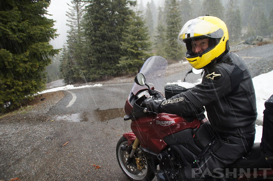
Getting snowed on atop 6100 ft Carter Summit in late May
Our riders love coming here, it’s a destination. Forget about amusement parks and backyard BBQs, this is a special destination for those who love The Curve. Perfectly engineered, perfectly graded, mountain views, what’s not to love. This is what motorcycle daydreams are made of. And this stretch of road we call The Racetrack is so remote and in the middle of nowhere, it’ll never have any traffic on it. Twisty mountain road all to yourself, can that be real? It can, it is, and it’s just another day of riding the Northern California Motorcycling Paradise.
But it gets better.
There is no over-hyped drama of xxx Curves in xx Miles, rather The Racetrack flows for 30 miles, it goes and goes, with zero traffic. You’ll lose touch with reality as you flow through the curves one after the other. The Racetrack is mountain perfection and it reminds me of what Northern California is all about.


Closing Thoughts: Truckers
My favorite story, or rather least-favorite, about the Forks of Salmon involves truckers. As in 18-wheelers pulling 40-ft trailers, you know, interstates and crossing the nation on a whim. If the mere mention of such things after reading this article makes you amazed that those two things could be included in the same sentence, read on… Every couple of months seems word comes across the horn about another trucker, pulling a 40-foot trailer heading up the Forks of Salmon, often from Highway 96 headed east towards Etna.
The reason why this is so alarming, annoying, and downright ridiculous is as mentioned, we love to call this ride the Bolivian Death Road. If you’ve figured out by the second paragraph that single lane, death, road, and 18-wheelers don’t go together, give that man a cigar.
A common scenario is truckers traveling eastbound on Highway 299 (Ironically the trucking route), and then turning north on Highway 96 (worst choice ever) and then their GPS diverts them onto what’s referred to as the mainstem Salmon River Rd to get back to the Interstate 5 corridor. At last count, this occurs 3-4 times yearly. A giant yellow sign along Highway 96 at the beginning of Salmon River Rd proclaims ‘Your GPS is wrong!’ which is painfully funny, amusing, and all too true in the same breath. Every time a trucker heads up this road, the locals simply shake their heads.


From the Pashnit Mailbag:
I spent the night in Yreka which afforded me the opportunity to head west out on California's northernmost ride, Highway 96, as the first order of the day. Nice way to wake up. I'd heard about Salmon River Road on the pashnit.com site and thought I'd check it out. At the confluence of the Klamath and Salmon River, I headed east onto Salmon River Road. The road is a nice, twisty two-laner. But it does not stay that way for long.
The centerline disappears, and the going gets narrow and bumpy as you wind up towards Forks of Salmon. While not exactly cratered, this road deteriorates in a hurry with gravel and rocks just about anywhere, a lot of blind turns, and an impressive drop-off to the Salmon River. Indeed, there are sections of road that are so eroded underneath, you feel like you are riding on a shelf.
So while not exactly racer-boy stuff, this road will give you an "adventure" aspect to your day that you would not get on Highway 1. And the scenery, breathtaking. Eventually, you lose the river, the road continues its gnarly way. Then bam, the tarmac changes into a gorgeous, two-lane racetrack quality road with good visibility and a beautiful rhythm to the turns that allow one to go just as hard and fast as they wish.
The turns are pretty consistent, and you will not be surprised- just elated. After a nice fast run up the Salmon Mountains, the temperature cools down a bit, then a nice fast run down to Highway 3 and Etna with some more good sections spaced between straightaways- which you have not seen in a while. Not a bad thing at all!
Pat Paull
BMW R1100S
Seattle, WA

Forks of Salmon - Bonus Photo Gallery


MORE INFO:
Forks of Salmon,
Salmon River Rd, Sawyers Bar Rd, Cecilville Rd
57 Miles - Highway 96 to Etna - LENGTH
65 Miles - Highway 96 to Callahan - LENGTH
Narrow single lane in middle of both forks - PAVEMENT
Numerous, sheer mountain drop-offs, no guard rails - CURVES
Highway 96 to Etna or Callahan - CONNECTS
Orleans, Cecilville, Etna - GAS
Weaverville, Yreka - LODGING
6000 ft - PEAK ELEVATION
Incredible scenery, extreme remote - HIGHLIGHTS
GPS LOCATION:
41°15′30″N 123°19′18″W - Forks of Salmon
41°27′26″N 122°53′49″- Etna
41°18′35″N 122°48′05″W- Callahan
LISTED CONNECTING SIDEROADS:
Highway 96
Highway 3
Gazelle-Callahan Rd
RELATED LINKS:
Film: Commune (2005)
History of the Salmon River Valley
Salmon River Restoration Council
Sawyers Bar - McBroom & Co. Packers & Guides

Maps
Video
