Northern California

Nevada County, California
Pleasant Valley Rd
16 Miles - Length
Nevada- COUNTY
Includes single lane paved- PAVEMENT
CA Foothills, - CURVES
Penn Valley, Nevada City - GAS

Quick Ride: Explore the Longest Single Span Covered Bridge in the United States
Ride to Bridgeport Covered Bridge


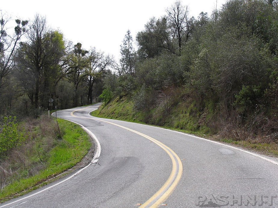
The ride has several good roller coaster curves, and the pavement is excellent on the southern half. Pleasant Valley Rd is a short cut from Highway 20, the main road between Marysville and Grass Valley, to Highway 49 Yuba Pass. In the middle of this ride is the Longest Single Span Covered Bridge in America. That alone is worth checking out on this road. The northern section climbing out of the canyon north from the bridge is single-lane-paved to French Corral where the road regains its composure into a wide and fast two lane foothill back road connecting to Highway 49. The phrasing may spark your interest. Did someone say single lane paved road? I’m there.
Ridden south to north, find Pleasant Valley Road west of Penn Valley. (Indian Springs Road & McCourtney Road south of Hwy 20 are fun rides too.) Pleasant Valley Rd is well marked and easy to locate. There's a mini-mart on the corner if you want to stock up on some quick eats and fuel up. A nearby golf course is adjacent to Lake Wildwood, a semi-private community of 5000 surrounding this small 300-acre lake built by developers in the late 1960s.
Be sure and check out the rather unique spillway that the road rides over. In springtime, quite a bit of water may be coming over the spillway in a half-moon shape. On the north side of the bridge over the spillway is Mooney Springs Rd. This connects back to Highway 20 and parallels Deer Creek in the usual twisty manner. A quick hint for the rider is if you headed uphill on Highway 20, exit the highway at Mooney Flat Rd a mile east of Smartsville. Mooney Flat Rd parallels Highway 20 and even provides extra twisties if the plan is to ride Pleasant Valley Rd on up to Highway 49 Yuba Pass plus avoiding all the congestion of Nevada City. If the ride plan is to make for Nevada City, use Mooney Flat to Pleasant Valley to Bitney Springs-Newtown Rd. This twisty route parallels Highway 20 and has a lot more twisties and turns. There, now you know.
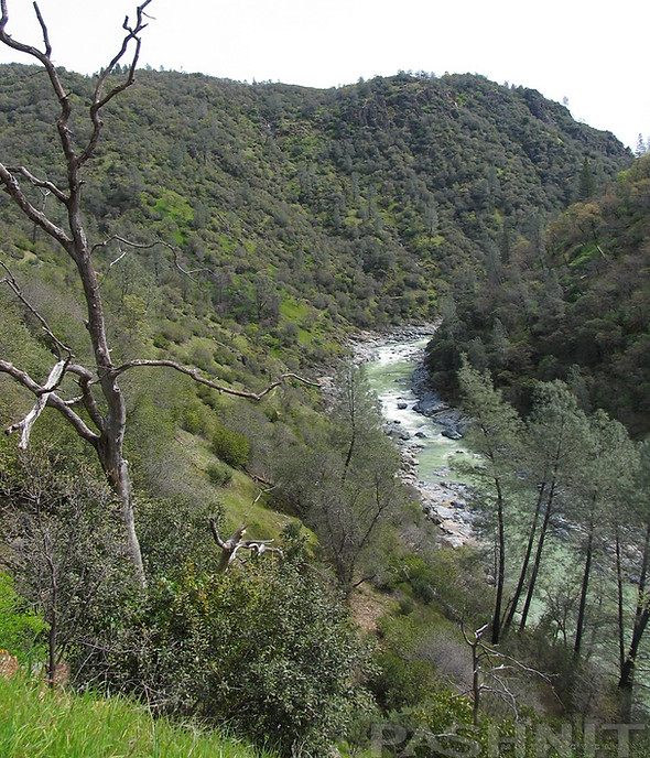
North of Lake Wildwood, the road begins to twist and you may even shout. Pleasant Valley Rd heads on down to the South Yuba River wiggling its way along. Pleasant Valley Rd has the distinction of being one of very few roads in the state where you can take a photo like the first one above. That hurried succession of rapid-fire curves. Not only does this downhill sequence offer up some quick left-rights, but throw in some whoops to keep things interesting.
This section is short, but worthy of turning around and running up the hill just to ride it the other way. Opposite way, different road, goes the motorcyclist's mantra. At the bottom of the hill, once the ride reaches the South Yuba River, you've entered Bridgeport State Park.
A modern bridge has long since replaced the use of the covered one. The covered bridge was closed to vehicle traffic in 1972. If you're lucky, it'll be open to walk across. The bridge underwent a major restoration in 2021. There is a tiny museum to check out the local history. Check the schedule of the park, as they do put on some events here.

Built in 1862 by David J. Wood with lumber from his mill in Sierra County. The covered bridge was part of the Virginia Turnpike Company toll road that served the northern mines and the Nevada Comstock Lode. The associated ranch and resources for rest and repair provided a necessary lifeline across the Sierra Nevada. Utilizing a unique combination truss and arch construction, Bridgeport Covered Bridge is one of the oldest housed spans in the western United States and the longest single span wooden covered bridge in the world.
Pleasant Valley Rd heads up to the longest single span covered bridge in America, right here in our backyard in Bridgeport. While there are other covered bridges that are longer, such as Knights Ferry, this one lays claim to being the longest single span covered bridge in the country.
The Bridgeport Covered Bridge was built in 1862 by the Virginia Turnpike Company. In January of 1862, a 1000-year storm washed over the Pacific Northwest, creating massive flooding in the Sierra Nevada Foothills, and washed the bridge away. The bridge was rebuilt by summer time with wood from David Wood's sawmill, 30 miles north of Bridgeport.
The bridge was 249 feet long including a 10-foot weather wing on each end. The actual span between the footings is 208 feet and the weather wings were later removed during a restoration. Today the bridge is 229 feet long and the clear span has remained the same since 1862.


The bridge is supported entirely by two trusses based off the design in the Howe patent. It's built of timber and iron rods and an Auxiliary Burr Arch which is bolted to the trusses and connects to the face of the abutments. An abutment is what the bridge ends sit atop of. All the weight of the bridge rests on these abutments. The wood is douglas fir and the 27,000 shingles are made of sugar pine.
The bridge owners charged a toll for passage over the river to both cover the cost of building the bridge and to turn a profit. Passage for 8 horses, mules, or ox team was $6.00, a man on foot was .25 cents. The gross income in 1863 was $20,915.45.

During the late 1990s, the bridge was heavily damaged when several major El Niño rain storms and unusually high temperatures in January melted massive amounts of snow in the Sierra Nevada Mountains and flooded area streams and rivers.
The phrase El Niño means The Little Boy, or Christ Child in Spanish. Recognition of El Niño weather patterns date as far back as the 1600s by fisherman off the coast of South America. The name was chosen based on the time of year (around December) during which these warm water events tended to occur with the appearance of unusually warm water in the Pacific Ocean creating large-scale ocean-atmosphere climate events. Said more simply, there's a tremendous amount of rain.
Rivers at this elevation rose over 20 feet washing away parts of nearby Highway 50 (east of Ice House Rd) and even entire homes. Levee breaks inundated entire low-lying towns in the Sacramento River Delta. The flood here ripped off shingles and damaged the structure from debris in the raging river. The 1997 storm flooding caused such devastation, it was thought at one point the entire bridge, standing for some 140 years, would be washed away. The water level actually matched that of the 1862 flood that washed away the original bridge. The bridge withstood the onslaught, and the storm damage was repaired.


Interesting to note that in 1970 during restoration efforts to preserve the bridge, the entire structure was raised 4 feet under the pretense it would provide better protection from flooding. Who would have thought that 37 years later, this foresight likely saved the bridge from being destroyed in 1997.
A large 1860s era barn remains facing the bridge built at the same time as the covered bridge in a classic Dutch style. The barn was used as a ‘filling station’ as teams of horses pulling freight could be driven straight into barn and rested before the climb out of the canyon. The barn was restored in 2007 with private funds and returned to its 1860 state. Currently 11 different wagons are kept in the barn highlighting 1850 to 1900 era of freight wagons. Freight was floated up the Sacramento River from San Francisco to Marysville / Yuba City and then off-loaded onto freight wagons. The wagon trains then began an arduous trek to the gold fields in the Sierra Nevada Foothills and all the way to Virginia City in Nevada via Henness Pass.

There are walking trails along the river, including a trail on the north side of the bridge that stretches to Englebright Reservoir 1 mile away to the west. Englebright Reservoir is a narrow and small reservoir downstream from the bridge.
The site of Bridgeport State Park is also a popular location for swimming and picnics along the sandy shores of the river. 150,000 visitors per year use South Yuba River State Park surrounding the bridge. 100-degree temps in the height of summer attract many locals who use the river to cool off.
After a bend was noticed in the bridge, an engineering survey was conducted and confirmed the bridge was warping. It was closed in 2011 as being structurally unsafe. Pedestrian traffic was halted until funds could be raised to refurbish the bridge. Over 150 years of wear began to show as joints were noticed having come undone and tension rods holding the bridge together were exceeding their capacities.
The grass-roots fight to save the historic bridge finally gained ground in 2014 when the state of California included $1.3M in their yearly budget for restoration and refurbishment. A subsequent $3.2M was built into the state budget in 2017 to further the restoration. Estimated restoration costs hover at $6.9M funded with a combination of state and federal funds.
The engineer plan is to preserve the bridge’s framework and prevent any further deformation. Due to the bridge being a national landmark, each piece that is not salvageable must be replaced with an exact replica.

During the restoration, original ‘stitch bolts’ and ‘square nails’ were reused wherever possible. Some original 1862 hardware was heated on an antique forge using coal and straightened on a handmade anvil right on-the-job site. Abutments on either side of the bridge were replaced and rebuilt to support the massive weight of the bridge. The $6.9M restoration of the bridge was completed in November 2021.

North of the South Yuba River, the road immediately narrows to single lane paved. I admit I was somewhat surprised because the road south of the river was so much fun. It would seem as if the county had enough funds to resurface and widen the road to the covered bridge and then gave up.
The view of the Yuba River Valley as you climb is spectacular and makes up for the poor condition of the road. Note that in winter and spring during seasonal rains, be especially mindful of road conditions, slides, water on the road, rocks, the usual. While the highway department endeavors to maintain the one-lane section on the north side, When I shot all these pics, one portion of the road had slid right off the mountainside and into the valley below. One lane wide with concrete barriers to prevent a similar fate, there were several CalTrans workers standing around assessing the damage. The road has since been repaired. Each year, results may vary.

French Corral
The one-lane section doesn't last long and a small collection of homes marks the Birchville French Corral area. French Corral is a tiny alcove of homes; you might easily ride right on through it with nary a thought if it were not for the vintage Wells Fargo building. Said to have contained millions of dollars in gold in the 1850s, French Corral was once one of many bustling Gold Rush towns containing thousands of miners swarming over the hills and valleys.
Dating to 1849, French Corral was one of the earliest gold discoveries as settlers pushed into the California Foothills mining the rich veins of the North San Juan River channel. The name was credited to a Frenchman who built a corral for his mules, around which a town sprang up. Early settlers discovered fertile soil at this elevation and planted vineyards and citrus. Many towns of that era were started by a mere tent, soon replaced with a log cabin that operated as a trading post.

French Corral was a stopping point for Argonauts headed into the foothills bound for North San Juan, Nevada City and Grass Valley. With the introduction of hydraulic mining, a process where high pressure water hoses were used to blast away entire hillsides, French Corral quickly became one of the premier towns in the region, second only to North San Juan in size and importance. By the 1880s, several hundred people resided at French Corral spread across 70 homes. Fires were common during this time and often burned the town to the ground, followed by rebuilding the town virtually overnight. Hydraulic mining was started in 1852 lasting through 1884 when it was banned.
Diamonds were said to be discovered during the process of hydraulic mining in and around French Corral. Sometime before 1867, a 7¼ carat diamond, the largest known to have come from California, was found here in a sluice box. The present-day prices per carat range from $11,313 to $171,927.
Several ditches were constructed diverting water from higher elevations leading to French Corral at the 1500 ft level to supply water for the hydraulic mining. Over 320 miles of ditches, flumes and reservoirs were constructed to bring water to area mines. Once hydraulic mining was banned in 1884, estimates were only half of the gold in the ancient riverbeds of the Yuba River had been removed. The gold removed from around the French Corral region was estimated at $3 million to $4 million in period values. Mining resumed in the 1960s through the late 1980s, often smaller operations with simply a bulldozer and a washing plant.
French Corral was also the site of the first long-distance telephone line in the United States which ran for 58 miles and was built in 1877 by the Edison Company for the Milton Mining Company at a cost of $6000. It reached up the Ridge from French Corral passing through Birchville, Sweetland, North San Juan, Cherokee, North Columbia, Lake City, North Bloomfield, Moore’s Flat, Graniteville, Milton, and Bowman Lake. The line was constructed for three mining companies, the Eureka Lake and Yuba Canal Company, the North Bloomfield Mining Company, and the Milton Mining and Water Company, for the purpose of effectively managing the flow of water in their ditches and flumes along the San Juan Ridge.
The three companies owned and operated a total of over 320 miles of ditches and flumes, constructed at a cost of over $5 million. The novel for the time phone line enabled them to precisely regulate the volume and flow of water from the reservoirs high in the mountains, through the complicated system of flumes and ditches, to their gigantic hydraulic mining operations along the San Juan Ridge. This gold laden east-west ridgeline reached all that up to Malakoff Diggins further up the hill. Little hint of a town remains, only the Wells Fargo building, dated to 1853 still stands in a bend in the road, an echo of another California Ghost Town. French Corral to Highway 49 is a mere four miles away through a fast two lane with gentle curves and excellent pavement.


However, if you seek more Gold Rush history, two miles northeast of French Corral, catch Birchville Road which takes you directly to Tyler-Foote Crossing Road 4-miles away. Birchville Road is single-lane-paved with fair pavement wiggling its way higher in elevation with several good views south towards Jones Ravine and the South Yuba River in the canyon below. At Highway 49, simply continue across the highway and continue the journey up to North San Juan and Malakoff Diggins. If you like gold mines, you must visit Malakoff Diggins, said to be the largest hydraulic mine operation in the world. Malakoff Diggins was an attempt to wash away entire mountains in search of gold, it also created one of the largest ecological disasters of the time. Hydraulic mining was banned in 1884 due to the massive harm to the environment caused by this type of mining. The first environmental protection legislation ever passed in America was due to Hydraulic Mining.
While Birchville is labeled on the map, there is only a hint of a collection of homes that might represent a town. Head north, continue up Pleasant Valley Road where it runs headlong into Highway 49 at Sweetland, only a short distance north of Tyler-Foote Crossing Road. North will take you up Yuba Pass to Downieville and Sierraville.
Ride Tyler-Foote Crossing Road up to the ghost town of North Bloomfield and Malakoff Diggins to check out the largest open pit Gold Mine in America.
For those of you who like covered bridges, do read about Knights Ferry Covered Bridge. North of here, there was another covered bridge east of Chico on Honey Run Road, but it burned in the massive 2018 Camp Fire that destroyed the entire town of Paradise. The Honey Run Covered Bridge was rather unique in that it had 3 distinct roof lines rather than more traditional styling like the Bridgeport or Knights Ferry covered bridges. The original bridge was built in 1886, but the roof wasn’t added until 1901. The Honey Run Covered Bridge was listed on the National Register of Historic Places and there is always interest by local preservation groups to rebuild an exact replica of the bridge to preserve the 1886 history. There's a total of 10 covered bridges in California so you may just want to seek them all out. The $6M Restoration of the Bridgeport Covered Bridge is thought to be completed by late 2021.

Where to next?
This is the Sierra Foothills and there are awesome roads in every direction. Here are a few suggestions you may have missed or overlooked.
North: Headed north takes you to Highway 49 Yuba Pass. Fun ride on up to Downieville and Sierra City. Take Gold Lakes Drive to connect with the retirement community of Graeagle and head north for La Porte Rd and circle back around via La Porte Rd.
South: Reaching Penn Valley, head across Highway 20 and continue a parallel trek along Highway 49 towards Auburn via Indian Springs Rd to McCourtney Rd to Lime Kiln Rd. This pops back out on Highway 49, but will also keep you off the main highway.
East: Don't miss the gold rush town of North San Juan and Malakoff Diggins. The whole town is now a state park but can be reached via Tyler-Foote Rd.
West: Headed downhill into the valley, note the aforementioned Mooney Flat Rd at the Lake Wildwood spillway provides a fun detour to keep you off Highway 20. Note you can also stay off Highway 20 by taking Smartsville Rd across the top of Beale AFB into Linda.
Pleasant Valley Rd - Photo Gallery


MORE INFO: Pleasant Valley Rd / Bridgeport Covered Bridge
RIDE IT on a PASHNIT TOUR
15 Miles - LENGTH
Short single lane, fair, twisty two-lane - PAVEMENT
Quite a few - CURVES
Penn Valley, Nevada City - GAS
Nevada City, Grass Valley - LODGING
1200 ft - PEAK ELEVATION
GPS LOCATION
39.292739, -121.194906 - Bridgeport Covered Bridge
LISTED CONNECTING SIDEROADS:
Mooney Flat Rd
Bittney Springs Rd
Birchville Rd
Highway 49 Yuba Pass
Tyler-Foote Rd
RELATED INFO:
