Ferndale to Hwy 101
Northern California
Mattole Road

The Lost Coast
66 Miles - LENGTH
Poor, bumpy, potholes, ever-changing - PAVEMENT
Smooth, hairpins, endless - CURVES
Ferndale to Avenue of the Giants - CONNECTS
Ferndale, Petrolia & Honeydew (maybe) - GAS

Quick Ride:
Remote, long, poor pavement for the duration, endless curves and stunning ocean views, Not for everyone but a must-do road for many motorcyclists.
HIGHLIGHTS
Fernbridge
Imagine with me this out of the way less traveled back country road in the most pristine of settings.
It's called the Lost Coast because it's the last piece of California Coastline that remains virgin & undeveloped. It was named the "Lost Coast" after the area experienced depopulation in the 1930s. In addition, the steepness and related geotechnical challenges of the coastal mountains made this stretch of coastline too costly for state highway or county road builders to establish routes through the area, leaving it the most undeveloped and remote portion of the California Coast. The Lost Coast is Big Sur on steroids. Back in the 1960s when Highway 1 was planned, the coastline was thought to be so rugged, they simply detoured around it (& created the much-loved Leggett section of Highway 1). Most of the region's coastline is now part of either Sinkyone Wilderness State Park or King Range National Conservation Area.

The beauty of it is, few know about this road. Mattole Rd is the sort of ride where you could park the bike, turn the key to the off position and listen to total silence. Mattole Rd doesn’t go anywhere. It doesn’t lead to any city, and there are no major roads that intersect it. The two towns along the ride of Petrolia & Honeydew are so small, they have a single building and a few residences. Your classical image of what a town looks like, this isn’t it.
On this ride, it was a day of exploration.
No plan. No direction.
Tooling around northern California crossing off roads astride the motorcycle unaware of what may lay ahead. It was the kind of day where you leave home base and have no idea where you're going. You're just riding and that's all that matters.

There is a sensation to the Pacific Coastline here unlike anything California has to offer. What makes The Lost Coast different is this is an untouched land up here devoid of people, civilization or big box stores.
If you plan a ride up this way, do not miss this one. Granted, this is not a high-speed ride and the road is old, forgotten, bumpy and ever changing- but that's the last thing you'll be thinking about.
California has no shortage of wilderness areas. The Lost Coast is by far one of the largest at 67,500 acres of undeveloped land. It also contains the longest stretch of undeveloped Pacific Coastline in the continental United States.
To reach the northern end of Mattole Rd, we'll start from Ferndale. Neither direction is better than the other, the redwoods are on the southern end, and the ocean portion is in the northern half. Only one paved road, Wilder Ridge Rd, intersects this 66-mile loop.


You can also ride inbound from Scotia or Rio Dell. Exit Highway 101 at Exit 681 Wildwood Avenue, and an immediate turn northwest on Belleview Avenue at the Rio Dell Baptist Church (which turns into Blue Slide Road) at the northern terminus of the Avenue of the Giants. The road hugs the western edge of the Eel River across a flat plain lined in dairy farms then becoming Grizzly Bluff Road and reaches Ferndale 12 miles later.
To reach Ferndale from Eureka or Fortuna (and nearby Highway 36), ride Highway 211 from Highway 101 at Fernbridge.
Fernbridge really isn’t a town, but rather an t-shaped intersection. Fernbridge Tractor & Equipment and the Humboldt Creamery across the street are all that mark the remains of the town established in 1885 as a ferry crossing. Dairy is king here and by 1890, there were eleven separate creameries operating in the Ferndale area.
The ferry across the Eel River is long gone though and, in its place, you’ll need to cross a 1320 ft concrete bridge. Gephyrophobics need not apply. The bridge was built in 1911 and has seven 180-foot long arches with long ramps on either side.
When built, it was named the "Queen of Bridges" and is still the longest functional poured concrete bridge in operation in the world.
In 1987, CalTrans proposed building a new modern bridge to replace the ¼ mile reinforced concrete span, the motion was vehemently opposed by the locals and instead, Fernbridge was added to the National Register of Historic Places on April 2, 1987.

There is a small museum in Ferndale to learn the local history if you have the time. (515 Shaw Ave, Ferndale, CA 95536). It’s well worth the visit and the last time I brought a Pashnit Tour group here, our elderly docent described growing up in the town and shared how up until 1983, Ferndale still had a human-operated phone switchboard (think Andy Griffith) for routing local calls (now in the museum). Two crank phones remain in the museum, and you can call from one to the other. A century-old seismograph continues to record the Earth's movements. Collections include over 6,000 photographs, back issues of the Ferndale Enterprise newspaper, and family papers spanning 140 years. As a center of farming and dairy in the late 1800s, produce from Ferndale was shipped out via Centerville and transferred to ships at anchor offshore prior to the opening of docks at Port Kenyon in 1876.

Our docent also provided a first-hand account of the massive 1964 Christmas Flood along the Eel River that devastated the region in December 1964. More than 11 inches of rain fell in 24 hours and that was after heavy snows had fallen in early December which melted and combined with the rain.
The 1964 flood killed 29 people and injured 1,700. At least 4,784 homes, 374 businesses and 800 farm buildings were destroyed, 5000 head of livestock were lost and 16 highway bridges were destroyed as far inland as Willow Creek along Highway 299 (the Bigfoot Museum in Willow Creek also has a very detailed account of the 1964 flood). 34 Counties in California were declared a disaster area.
With logging being the principal employer in the region in the 1960s and their facilities located along the rivers, flood waters overflowed river banks and washed millions in dollars of logs downstream affecting 4000 workers. The deluge of logs helped to destroy nearly every bridge along the Eel River.
The 1964 Flood washed away entire towns, some were never rebuilt. At Miranda in the present-day Avenue of the Giants, the Eel River rose 46 feet. If you watch closely, you can still see high water signs along the Avenue of the Giants that are 10 plus feet over the road surface.
Ferndale only has a few streets, but is surrounded by Victorian homes, some falling apart, others fixed up nicely.


As the area dairy farms prospered in the late 1880s, dairy farmers built ornate Victorian homes which came to be known as the Butterfat Palaces of Cream City. Ferndale quickly became one of the state's most productive agricultural regions. Many of these dairy farms are still in operation today. Ferndale is tiny, a mere 1300 people, but it's famous as a touristy destination, and for the World Championship Great Arcata To Ferndale Cross Country Kinetic Sculpture Race. The Humboldt County Fairgrounds are also located in town with the yearly county fair in mid-August.
The Victorian homes and buildings are a photographer's delight. Many of these buildings in Ferndale originally date from the 1880s. The entire town is registered as California Historical Landmark #883 and its small size makes it perfect for walking.
Find Mattole Road one block west of Main Street in downtown Ferndale near the Victorian Hotel. There is a large sign denoting the way to Capetown and Petrolia. Although before attacking Mattole Road, ride out to the coastline via Centerville Road to Centerville Beach County Park. Once you hit the ocean, keep riding as the road hairpins around the hillside past a parking area. Watch out for lots of ocean sand on the road in this hairpin.
Centerville Rd becomes gravel here by an abandoned military installation but continues a few miles towards two different parking areas for hikes out to the coastline.

Centerville Road to former Naval Facility Centerville Beach

Naval Facility Centerville Beach was commissioned on 25 March 1958. One of the many underwater listening stations that were part of the Sound Surveillance System (SOSUS) and the Integrated Undersea Surveillance System (IUSS), which were used to track Soviet submarines during the Cold War. From the original compliment of ninety-five personnel and sixteen buildings, it grew to 280 personnel and twenty-four major structures.
It was situated on thirty-seven acres of rolling pasture land on a 320-foot cliff overlooking the Eel River Valley to the North and bordered by the Pacific Ocean to the West. In addition to its operational responsibilities, NAVFAC Centerville Beach also marked the location of the Readiness Training Facility from 1978 to 1985.

Naval Facility Centerville Beach
After weathering three earthquakes in 1992, NAVFAC Centerville Beach was re-terminated at NOPF Whidbey Island and decommissioned 30 September 1993 after nearly thirty-five years of dedicated service.
NAVFAC Centerville Beach in 1992 survived 3 earthquakes registering 6.9, 7.0, and 7.1 on the Richter scale. My first visit to the facility was around 1996 and Centerville Rd in front of the facility had recently collapsed into the ocean. The pavement led right up to the edge of a cliff.
In 2011, the buildings were razed and completely removed from the site. The former base was recently bought by the town of Ferndale from the United States Navy for the pricey sum of $1 and the city has plans for housing.

Centerville Beach

Centerville Rd to Fleener Creek Overlook
Beyond the facility is the Lost Coast Headlands, and the Fleener Creek Overlook parking area that allows easy access via hiking trails back down to the ocean. Centerville Rd becomes single-lane gravel at Fleener Creek just past this parking area.
Guthrie Creek Trailhead parking area is a short distance across the valley. The Guthrie Creek Trail is a short trail to a beautiful remote beach in the Lost Coast Headlands. The trail is fairly steep and can be muddy in sections, including at the bottom where the beach can be difficult to access due to mud. After hiking down to the ocean, at the base of these steep walls you can find fossils embedded in the compacted ash and sandstone.
Centerville Rd ends at a private residence a few miles south of the Guthrie Creek Trail parking area.
Mattole Road starts out from Ferndale as a narrow path heading up to the crest of Bear River Ridge climbing some 2000 feet in a mere 4 miles to introduce the ride. Atop the ridgeline, the forest fades into the lower elevations. The coastal wind wafts across blades of grass that span brilliant green pastures demarcated by well-weathered fence lines laid decades ago fading away in the salt air.
Mattole Rd emerges from the forest and you'll see the ocean for the first time. A breathtaking view, but the best is yet to come. There are several switchbacks to contend with, but they ease down the hillside blanketed in that reoccurring green grass, or rather green fields full of cows and goats. The road surface is the same level as the pastures with no fences.

The Bear River at Capetown
Six miles outside of Ferndale, the one side road on this early portion of the ride appears at Malfunction Junction. Upper Bear River Ridge Rd is signed and connects back to Rio Dell at Hwy 101. This road is paved at first, but evolves to one-lane gravel and the pavement resumes when nearing Rio Dell.
Mattole Road peaks across a low ridgeline lined with several farms and endless green grass. Wonderful views stretch out west to the ocean as a screen of blue fills the horizon. Mattole Rd throws out several switchbacks here to descend to Capetown, which really isn’t a town despite its misleading name and has nothing to do with South Africa. It’s a single farm and a creek (Bear River) with the post office last operating in 1937. Capetown used to be a former stagecoach stop and this is also the westernmost settlement in California.


View of Capetown Valley
Mattole Rd continues up and over the hill through a stand of trees emerging into fence lined green meadows. If you are able to ride this in the California Spring of April or May, these meadows are awash in an intense brilliance of green. Massive trees beside the road are coated in a thick layer of stringy moss hanging from a hundred branches.
The road surface never improves although it can be teasingly smooth at times, then a bumpy patched affair. Choose your line carefully and ease off on the speed flowing past the Cape Ranch. As you reach the top of the ridgeline, the view to the north across the meadows is all ocean. Note there are some gravel pullouts in corners in this section and gravel dust can be thrown up on the road surface. Be mindful of these dangers and ease around these corners.
To make the ride a bit more interesting, you may come around a corner and the pavement simply ends. An orange cone denotes a hundred-yard-long section of gravel to traverse. Just another day on Mattole Rd, next season, it’s all been repaired and the gravel strips will be elsewhere. But its worth mentioning we’ve never ridden this road where riders have not encountered these short strips of gravel as Humboldt County works tirelessly to maintain the road.
This particular downhill section of road to Singley Creek has always been in poor condition despite road crews attempts to maintain it. Some years, massive potholes pop up when you least expect them, other years, the ground beneath the road seems fluid and it is busy sliding into the valley below. Other years we’ve ridden this portion as a single lane along concrete barriers. It is a constant reminder to take your time, and keep your eyes on the road surface despite the view.


This steep descent at Singley Creek, riders have often remarked looks straight up when viewed northbound. When viewed from the beach while riding the long straight, it does have that optical illusion quality to it and it makes the ride all the more interesting and unique.
At the bottom of the hill past Beach Rock and Singley Creek, is a pullout and a plaque denoting the lighthouse operated from 1868 to 1951. It fell into disrepair but was eventually transported piece by piece to Shelter Cove. A few years ago, it was restored and can now be viewed on the south end of the runway in Shelter Cove. A replica can also be found at the Humboldt County Fairgrounds in Ferndale.

Ascent at Singley Creek along Mattole Rd, Sugarloaf Island in the background

Worth noting, this region you see in these photos is said to be the most seismically active region in the United States (excluding Alaska & Hawaii). An earthquake in 1992 reached 7.2 on the Richter Scale with its epicenter near Petrolia.
Flowing down the hill, the road falls down to the Pacific coastline. Here is where tranquility begins. Before you lies you one of the most wondrous deserted stretches of pavement in all of California.
Be wary of cows in the road though as they roam freely. This one below in the photo was hiding in these bushes that lined the road and popped out right in front of me missing the bike by mere feet.
Also note the flatbed railroad train car that is now a bridge. It's all steel, so if wet, use a smooth throttle and glide across. And just offshore is Steamboat Rock, which you may have guessed looks like a boat. Smooth sand beaches and tide pools line the road. Deserted, not a soul as the waves endlessly crash against aging driftwood and numerous offshore rocks. Bring the sea kayak to explore the rocky shoreline.
The pavement smooths out here, but be ever vigilant for potholes. A decade ago on a Pashnit Motorcycle Tour, a Canadian rider on a rented BMW came blazing down this long straight at 60 mph and hit a 12-inch diameter pothole. The front rim bent and the tire went flat in minutes. With no way to pump it back up, he wondered what do I do? Ride it said the guide, and he did so gingerly into Ferndale. Our first thought was to find a hardware store, there was none, but Ferndale did have a Farm Supply store.
We pulled the bike round the back and showed the employee our plight. He walked up to the front of the building and pulled a sledgehammer off the rack. Careful to not strike the rotors, we pounded the rim back into place with the sledgehammer and refilled the tire. Not pretty, but our Canadian finished the ride we think a bit wiser.
This stretch along the ocean is a dreamy piece of pavement curling around Devils Gate. How smooth or how goaty isn't really important, it's that sensation again. All that remoteness, isolation, and rugged coastline all collide in these brief moments along the ocean coastline. Heavenly. Make sure to stop and smell the roses or rather the salt air. The loop is a long one, over 60 miles, and the ocean portion is short, so make time in your journey to rest a spell and enjoy the sound of the waves.
You know how in the travel brochure they only show you the best parts of the travel destination? That’s Mattole Rd. What most won’t tell you is the portion of this ride along the ocean is a mere 7 miles, of a 66-mile loop. That’s 10%. In reality, 90% of this ride is not along the coast despite the alluring name and is rather the twisty back road sort wandering through the coast range. That’s the reality of it, but you came to ride.
The ride along the coast ends all-too-quickly reaching Petrolia just five miles inland. In the 1850s, white settlers originally named the place New Jerusalem. When the first oil was pumped in 1865, it was renamed Petrolia. The first oil wells in California were drilled here in the 1860s after the American Civil War and the oil pumped to waiting tankers offshore. Although the “Old Union Well” initially yielded about 30 barrels of high quality oil, production soon slowed to one barrel per day and the prospect was abandoned.


Across the street from the Petrolia General Store is a state historical marker (no. 543) dedicated on November 10, 1955 that reads: California's first drilled oil wells producing crude to be refined and sold commercially were located on the North Fork of the Mattole River approximately three miles east of here. The old Union Mattole Oil Company made its first shipment of oil from here in June 1865 to a San Francisco Refinery. Many old well heads remain today.
Ride into Petrolia

Petrolia is only sort of a town. There’s the general store next to the Petrolia Fire Department and that’s about it. There’s a single 1980s era gas pump from an above ground tank at the Petrolia general store but we’ve never planned to fill up here. Ride past the Mattole Valley Community Center and the elementary school and the road teases you with a smooth two-lane with center line as it leaves the town behind.
Upon crossing the Mattole River on the south side of Petrolia, you'll come to Lighthouse Road. This heads a few miles out to the coast and a campground at the end of the road up against the beach. Here you can stroll along the beach or even hike the 20 some miles along the coastline to Shelter Cove.

Honeydew General Store
For the dedicated lighthouse buffs, south 3.5 miles is the Punta Gorda Lighthouse where you'll need to walk along the sandy beach to reach, however it may be inaccessible at high tide and requires wading across a creek during winter months.
After the loss of nine ships along this isolated section of The Lost Coast, the Punta Gorda Lighthouse was put into operation in 1912 and three adjacent homes built. Replaced by a navigational buoy in 1951, the lighthouse was then closed.
Surrounding outbuildings were burned down by the BLM in 1970 leaving the tower and oil house that remain today. It was restored in 1989.

Honeydew is 15 miles eastward as Mattole Road switchbacks out of the Mattole Valley and then falls back down and snakes back and forth across the Mattole River several times. Mattole Road can narrow to one lane in places. Don’t expect the pavement (a random portion pictured above) to improve any time soon.
The tiny ranching town of Honeydew sits within a picturesque mountain valley, hidden within the King Range and frozen in time, or possibly the 1960s. Honeydew is also the main intersection to head back east or south. The region is so isolated, it's thought that at least half the area residents are 'off-the-grid' or rely on solar power and other means.
At the Honeydew Country Store, one of our favorite places for an ice cream break, Mattole Rd intersects with Wilder Ridge Rd, which will connect with Shelter Cove to the south and Garberville along Highway 101. It is paved and a personal favorite. The pavement does extend all the way to Shelter Cove Rd and Ettersburg. Honeydew isn’t large, merely an intersection at the general store. But it is at the confluence of the only two roads in the region. Wilder Ridge connects south & there are some short sections of gravel.

Mattole River Valley
Mattole Rd leaves Honeydew via a 1920s era steel girder bridge across the Mattole River. The bridge has a wood plank surface and the county plans to replace the wooden bridge due to functional obsolescence, but for now it remains.
The plan to build a new bridge has been on-going since 1997. Can’t find many wood plank bridges any more, it will be missed. When they do finally get around to constructing the new bridge, a temporary bridge will be constructed 1,300 feet downstream from the existing bridge and the modern (likely) concrete bridge will be built in the same footprint as the original steel girder bridge.


Wilder Ridge Rd connects Honeydew with Shelter Cove Rd


Wilder Ridge Rd
At the Honeydew General Store, Mattole Rd continues across the bridge, but Wilder Ridge Rd heads south. This connects to Shelter Cove Rd and is paved except for a steep gravel triple hairpin three miles outside of town. Why this has never been paved is enough to stump the world's smartest man. Ease on through and climb through the hairpin, the gravel doesn’t last and the pavement continues all the way to Shelter Cove Rd.
There is a fork in the road ten miles later, right would be Kings Peak Road which is dirt. The more traveled path is the continuation of Wilder Ridge Road which changes into Ettersburg-Honeydew Road for 11.5 more miles to Shelter Cove Road.
This stretch is very much a back road, narrow, no center line and very few people if any. There are numerous driveways so somebody must live here. At the T-intersection with Shelter Cove Rd, this is Ettersberg, but there is no town, just a remote intersection.
Shelter Cove is one of our all-time favorite ‘finds’ and we’ve been taking tour groups to the Inn of the Lost Coast for many years. There are several small boutique hotels, but Inn of the Lost Coast is far ahead of their neighbors, and we’ve tried them all.
Read up for the fascinating history of the shysters who sold off useless land to unsuspecting buyers in the 1960s to create Shelter Cove.
Shelter Cove lies at the bottom of a steep twisty section of pavement as you come down Shelter Cove Rd. The tiny alcove of 700 residents rests at the very edge of this bunt of land that juts out into the Pacific. There is lodging, food, fishing, and camping here. Not to mention an airplane landing strip along the coast that dominates this portion of coastline.
Shelter Cove is surrounded in steep mountainous ridge lines and one of the last untouched places on the California Coastline. Fishing boats still launch every morning out of the cove and whales migrate down the shoreline. Sea lions bark and the gulls above will be eyeing you for a meal. Be sure and visit the newly restored Cape Mendocino Lighthouse on the south end of the runway. On the north end of the town are black sand beaches. Make sure to gas up before heading out to Shelter Cove.
You'll have to return the way you came as there is only one paved road to the town and it's 24 miles to Redway back up the steep hill you just came down. There isn’t much populace at the end of this dead-end road. However, when you arrive in Shelter Cove, you'll quickly figure out why the townspeople choose to call this very remote place home.
It’s also worth noting about snow. Not exactly anticipated, leading a tour in March always has a bit of weather unpredictability to it. The snowline on this cold ride dropped down to 2000 feet, and as the snow increased during the climb over the low pass to Honeydew, our doubts began to grow stronger. Could we make it over to Honeydew on the other side? The good news was a snow plow had passed through an hour earlier and plowed off the layer of wet slushy snow.
By the time we reached the top of the pass, there was already six inches of snow on the ground. The tour group made it just fine but don’t think I made any friends that day. Just remember, it’s the adventures you remember the most. As soon as we began the descent to Honeydew, the snow faded away as if it had never happened. The snow experience did make for some fun stories over dinner.

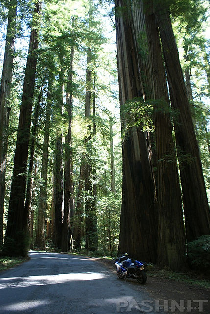
On the east side of the Coast Range lies the Eel River. Mattole Rd drops into Humboldt Redwoods State Park and the road is so narrow and bumpy here, large autos will have to pull over to let an opposing vehicle pass by. The redwood forest never gets old though and regardless of how many times you see giant redwoods, they always impress. The heights, the green, the lushness all combine into a neck stretching experience for the ride through the park.
After 66 miles of Mattole Rd, it finally intersects the Avenue of the Giants, aka Highway 254 and the Highway 101 freeway at South Fork. Rockefeller Forest is around the corner. Across the river is the Dyerville Giant and the Founders Grove, massive trees that have to be seen to be believed and well worth checking out.
North goes back to Scotia, Fortuna and Highway 36. Southward takes you to Benbow and a host of other tiny redwood towns. If the intent is to continue the ride down the coast on Highway 1, the Leggett Section is just miles away.
Take a few breaks along this ride when the view presents itself. We have ridden this route with motorcycle tour groups in rain, snow, ocean haze, thick fog, wind, rain again, drizzle, mist, and yes, brilliant warm sunny days where the ocean was glowing blue, the pictures vibrant with color and the spring grass awash with endless green. Any ride along the ocean is a bit of a gamble, if it’s great weather for you, then you’re golden and the weather gods have smiled on your journey.
One tour, the fog was so thick, we couldn’t see 20 feet in front of us. I slowed way down and eased my way along through the twisty turns nearing Ferndale. When we finally reached the Victorian Hotel for lunch in Ferndale, I asked the guys feeling somewhat embarrassed at our slow pace. The pace was perfect the riders assured me sharing they couldn’t see a thing either.

6200 Words later, it's hopefully clear Mattole Road isn’t for everyone. The 66-miles is long, you could even call it laborious, it’s endlessly bumpy and the pavement is poor throughout, just when you think it’s improving, it throws you back a few decades. Then to taunt you even more, it throws out a short stretch of gravel. But it has a cool name, and for we riders, that’s all we need.
Mention a place to a motorcyclist called “The Lost Coast” and the response is invariably going to be, “I have to check that out.”
And you should.
More Thoughts on Mattole Road:
I just returned from a four-day trip with three friends on which we explored several of the roads on your site. I probably wouldn't have found Mattole Road without reading about it on your site - we enjoyed it very much and it was certainly a memorable part of the trip. It was a great ride despite the fact that it was quite windy and cold at the coast, although not a bit foggy, so probably worth the trade-off. The paving on Mattole Road is pretty lousy and there were several sections that were gravel.
A small bridge between Honeydew and the coast was out and was replaced with a short, steep, gravel approach on each side and a railroad car across the stream! I had a fine time on my BMW R1100GS - my friends (two on ST1100's and one on a Harley Road King) were a little less enthused about adventure touring than I.
The road up the hill at the north end of the oceanfront section will be recalled again and again. I don't know if you find it that memorable since it sounded like you rode from Ferndale south, but when you ride Mattole Road northbound, it looks like it heads up the hill at about a 45-degree angle. The other part we really enjoyed was the ride through the redwood grove at the start just north of Weott on 101. Great redwoods and even a couple of campgrounds that I'm planning to revisit.
Mattole Road was an experience in a lot of ways. As one of my companions said: "Parts of that road were almost paved". It wasn't quite THAT bad, but I would probably hesitate taking a hard-core sportbike rider or "Wing Nut" out there without explaining that it's not smooth as a baby's butt and that there will be some really tight, bumpy and perhaps gravelly turns to contend with, as well as some gravel sections a hundred yards long or so. For 'adventure touring' bikes like the R100GS or R1100/1150GS, Triumph Tiger, Aprilia CapoNord, Guzzi Quota, KLR, etc., it's just a terrific ride.
It's a great road, no doubt about it. I've never been to Britain, but I expect that the upland terrain along Mattole Road shares a lot with Yorkshire or Scotland. Then there's that fabulous redwood grove at the 101 end, which was just fantastic- I'm looking forward to going back there with my wife and kids to camp in the campground.
-Pete Bansen
BMW R1100GS
Just finished a 4000-mile ride, most of which was in California. Used your web-site as a guide for the trip. Did many of the northern California roads you talked about (96, 299, 3, 36, and on and on) Loved them all. That is, all but one. The "Lost Coast" Highway that goes through Petrolia was a bust. Road is way too rough for enjoyable riding in my opinion. But one bust out of 15 good ones isn't bad.
Don Gibson
2000 Kawasaki Concours
What a road that was - fantastic scenery and incredible curves. Pavement quality was indeed a factor but worth every bone-jarring bump (really, it wasn't that bad). Coming into the Redwoods was amazing as well, and as someone mentioned it was very reminiscent of whipping through Endor on a land speeder. Just gorgeous.
CDN, Honda VFR
And a regret or two...
I headed to the Lost Coast on Hwy 211, which I kind of regret. The road there is like the worst goat trail and the Lost Coast, although not very populated is not really nicer than any of stretches of Hwy 1 that extend close to the ocean.
Then I realized that I got that idea from a trip report from a 1150GS rider. No wonder! I was set on camping on Mattole Beach, but the 2-3 mile gravel road made it the worst ride imaginable. If only my bike could talk, it would be cursing my ass!!
When I got there, it was 2pm and too early to camp. So, I decided to get back to 101 which was nice because I had to pass through another stretch of the Avenue of the Giants.
-Nelson


I emailed you a couple of weeks ago in preparation for our 3K mile trip that started in Seattle and went through many areas or Oregon and some of N. CA. I put the Alderpoint and Mattole roads in the route on one day, from Ukiah to Arcata. It was a 12-hour day.
I am riding a 2003 Honda GL1800 and the road over Alderpoint was a challenge. Mattole Road from Garberville to Honeydew was beyond a challenge and the last 100 feet of wooden bridge was almost too much. Little did I know what to expect further on over the Lost Coast road and up and over to Ferndale!
It was very, very challenging. My buddy was riding a Dyna Low rider and was waiting 20 minutes for me at the end, in Ferndale. I did stop to take some photos of the Lost Coast road but other than that, I had to pretty much “crawl” down the hill towards Ferndale.
Thanks for the recommendations (mostly). I can say I’ve done it but wouldn’t want to go there again. P.S. Honeydew – circa 1968… -Dave Steckler

Closing Thoughts
I’ve read about it and most of what I’ve read has kept me away. Tempted though. Most reviews I’ve read read more like warnings. –Dave
Yup! Rode it on a Harley Road Glide towing a cargo trailer! That bridge was no fun trying to get bike wheels and trailer wheels to stay on the raised part. But the scenery was well worth the effort. I would do it again. – Mike
Not an easy road to ride nor in very good condition in parts but that all adds to the uniqueness of the ride. Smooth and straight is of little interest. - Bruce
I hated that road. Nothing to see. Damn potholes. Now can we keep this route our little secret?????? – Mike
Rode it on a Shadow Spirit 1100. Dumped my bike in about a metric ton of soft earth they were trucking in to raise the level of the road. No bike damage, no rider damage. Scenery was great for about 20% of the ride, but wouldn’t ride it again. – Ally
I rode Mattole/Wilder Ridge on my way back from the Pashnit Trinity tour. OMG. Heaven on earth! Very few roads get up to Mattole's level of awesome. Completely deserted, rocks and bumps, potholes, WAY past ultra-twisty, jaw-dropping views, every mile left me screaming for more. – Mike
I remember stopping, turning around and looking back down the hill and feeling overcome – BJ

Mattole Rd - The Lost Coast - Photo Gallery


MORE INFO:
Mattole Road
66 Miles - Ferndale to Hwy 101 - FULL LENGTH
Poor, goaty, potholed, gravel sections - PAVEMENT
Smooth, gentle, sudden, hairpins - CURVES
Ferndale to Hwy 101 - CONNECTS
Ferndale, Petrolia & Honeydew (maybe) - GAS
Ferndale, Fortuna, Scotia - LODGING
2400ft - PEAK ELEVATION
Ocean Views, Remote, Redwoods - HIGHLIGHTS
GPS LOCATION
40°34.6′N 124°15.8′W - FERNDALE
40°14′40″N 124°07′22″W - HONEYDEW
LISTED CONNECTING SIDEROADS:
Upper Bear River Ridge Rd
Lighthouse Rd
Wilder Ridge Rd
Maps


