Northern California
Riding over Packard Ridge
Northern California
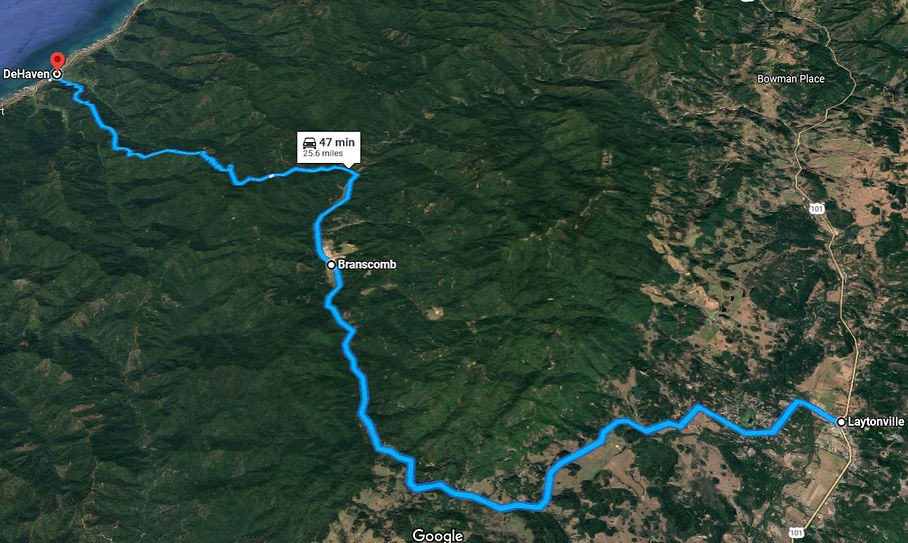
Branscomb Rd
25 miles - LENGTH
Very good condition- PAVEMENT
Tight, swoopy, hairpin - CURVES
Hwy 1 to Hwy 101 - CONNECTS
Laytonville, Fort Bragg - GAS

Quick Ride: Mendocino County ride up and over Packard Ridge from Laytonville to the Pacific Ocean. A welcome addition to any motorcycle ride.

Mendocino County Motorcycle Rides
There I was wondering how to update and rewrite the original 1000-word ride description of Branscomb Rd when I realized that I mentioned the timber mill still being in operation and noted lots of logging trucks.
How times change, the timber mill has long since shut down and you’ll have this one all to yourself. Branscomb Road is worth noting as the most northerly, last up and over mountain pass before Highway 1 over the Coast Range. It’s low elevation, but the mountain portion is great fun.
Find Branscomb Road in Laytonville along Hwy 101. There’s a restaurant on the corner called Boomers Saloon that our Pashnit Tour groups always stop at. Food is good and fast and they have a great club sandwich. Laytonville is a tiny shell of a town of about 1200 with a logging past. The foyer in Boomers Saloon is adorned with clippings and articles from this logging past which I can’t help but read. “Boomer” is a logging term referring to a man who doesn't stay long on any job; generally three days to three weeks. One who works just long enough to get a liquor stake and the "wrinkles out of his belly."

The lumber mill that I wrote about years ago has long-since shut down and the logging trucks are now all parked in someone’s lawn rusting into the ground. Laytonville does have gas, a hardware store and a small market. It’s a quick pass through town along Hwy 101, but has what you need if you need something while traveling.
Branscomb Rd is well-marked and found on the north side of town, intersecting with Hwy 101 at Boomers Saloon. It’s a fast ride headed west on a wide, smooth two lane. Leave town, headed past the High School into a small community west of town. Past the Red Fox Casino, speeds are eased off here as you make your way through this small neighborhood and across several broad meadows.
Note the solid waste facility is right on the edge of this community as there may be large trucks pulling out.


Mendocino Magic Campground is beyond the waste facility and offers up a 600-acre property for camping, glamping, weddings, reunions and concerts. Formerly a 600-acre logging camp and then a commercial trout farm, two small reservoirs offer up swimming and boating, including some clothing optional areas and beaches. There is a small sign for the campground last time we rode through here, but follow the link below to learn more about camping there, and Road 429B is marked as you ride past it to reach the campground on the north side of the road.
Branscomb Road meets up with the South Fork of the Eel River and sticks with it through Admiral William Standley State Recreation Area. The road has been a wide fast two lane so far but narrows a bit to squeeze between two large redwoods as it runs through this small 45-acre stand of old growth redwoods. There’s a Y-shaped pull-off for Mud Creek Rd right as the double yellow line ends, and the road narrows for a quick flash through the park. Somewhat puzzling, there are no facilities, no parking and no hiking trails other than Mud Creek Rd.

The park is named for Admiral William Standley, who commanded the battleship California from 1926 to 1927 and later the United States battle fleet at San Pedro, Los Angeles, until appointed Chief of Naval Operations by President Franklin D. Roosevelt in 1933. After retiring in 1937, Standley was recalled to active duty in 1941 and served as the United States ambassador to the Soviet Union from 1942 to 1943.
Once you pop out of the park, you’ll ride into the wonderfully green Branscomb Valley and run headlong into a tiny community.
Eight miles west from Laytonville, the tiny alcove of Branscomb comes up and here’s the wood mill that closed in 2012. Or at least what’s left of it, the small Branscomb Store closed in 2016, but what nostalgia to pull up and grab a photo of the gas prices.


They left the pump and sign. Step into the doorway and the mailboxes all remain. The town if you can call it that is anchored by a small trailer park with just 14 trailers and that’s it. The entire community in a few breaths.
Get ready for ‘Road Narrows’ three miles west of Branscomb, the double yellow fades away, and it’s a narrow lane all the way to the ocean from Redwood Creek. The narrow section flows into a dense forest and wastes no time throwing out the first 15-mph hairpin, which is truly 15 mph.
The climb to the summit of Packard Ridge is very short, just 1.4 miles from the end of the double yellow. However, at the summit is a terrific view to the south of the Pacific Ocean coastline in the distance. It’s worth the stop to pull over and take in the view. If it’s summer, you’ll be met with a blast of cool ocean air and the temps will drop 10-20 degrees.


The pavement at the summit of Packard Ridge is covered in graffiti and tends to evolve over the last 15 years we’ve been bringing tour groups to his ridgeline. Graffiti ranges from the high school-esque giant penis (we were never that young to find that funny) to expletive epithets of boy loves girl. Nothing remotely artistic like Graffiti Bridge on Wards Ferry Road in the Sierra Nevada, but the locals try.
The 6-mile descent to Highway 1 at the ocean from the top of Packard Ridge is pure joy on two wheels. That’s likely a rather weak literary iteration of a thrilling ride, but it’s the best I’ve got for the moment. The road is narrow, no center line for most of the descent, but that just means you have to be extra careful to be on the lookout for opposing traffic, especially in the blind corners.
Dropping to the level of the ocean involves a pleasing 8-10% grade wiggling down the crest of a mountainous finger. No wild hairpins in this downhill- just an amazing view in three directions through the trees. Note there are numerous driveways to residences.

If you're riding this uphill, it's a great ride, good pavement, no center line but wide enough for two vehicles. The ride swoops and dives, cuts left, then cuts right, tosses in a swoopy saddle in the middle, but sticks to the ridgeline following a steady descent to the ocean. It’s a super-fun rip-roarin’ ride, and the reason why you came all this way to ride Branscomb.
Branscomb Road is a welcome leg in your journey. Use it to combine with the Leggett section of Highway 1 which should not be missed (ever). When we lead Pashnit Motorcycle Tours, we ride from Fort Bragg via Hwy 20 to Willits, then skip north to Laytonville. From here, we can cut back out to the ocean via Branscomb, then cut back inland via Highway 1. We just did three coast mountain passes, all before lunch. Makes for the perfect day.


The ride pops out on the coast just north of Westport. Closest gas is in Fort Bragg 19-miles south, and these last towns of Westport & Union Landing along Highway 1 have nothing in them except a few bed & breakfast places of lodging. Across the highway where Branscomb Rd meets Hwy 1 is a campground perched on the very edge of the ocean, which is slowly crumbling into the crashing waves below. This used to be the highway before it was re-routed a few dozen feet further away from the coastline.
What remains is a good walking path along the ocean if you’d like a flat, level stroll leading up to Abalone Point within Westport Landing State Beach. Covering over three miles of rugged and scenic coastline, this beach consists of 46 campsites with ocean and mountain views. This walking path leads to Howard Creek and the Howard Creek Ranch Inn, a small B&B anchored by a ranch house dating back to 1871 on a 60-acre homestead
Depending on a bit of luck and the time of year, some days along the coast are shrouded in fog and constant wind. Other days we’ve ridden through here under endless blue skies and warm sunny days. It’s worth noting that if it’s hot temps inland, there will likely be fog as the cool ocean air collides with the 100-degree temps inland, the air combines and forms fog. We’ve ridden this stretch in July and never saw the ocean, despite being just mere feet from it. There can be constant wind. Other days there is a plethora of blue that stretches as far as the eye can see and illustrates why we love riding along the Pacific Ocean.
Branscomb Road will be a welcome addition to any motorcycle journey, it’s well-paved, well-maintained, and can handle any type of motorcycle large or small. The narrow section cut up and over Packard Ridge can be taken slow, easy, or enthusiastically. You may even want to ride it twice, headed up is twice as fun.
Related Links
Admiral William Standley State Recreation Area

Branscomb Road - Photo Gallery


MORE INFO: Branscomb Road
RIDE IT on a PASHNIT TOUR
25 Miles - LENGTH
Fair, usually in good condition - PAVEMENT
Up-n-over mountain ridge, swoopy - CURVES
Hwy 1 to Hwy 101 - CONNECTS
Laytonville, Fort Bragg - GAS
Numerous B&B's, campgrounds - LODGING
2500 Ft- PEAK ELEVATION
Packard Ridge - MOUNTAIN PASS
39°39′13″N 123°37′32″W - GPS LOCATION
None - LISTED SIDEROADS
Numerous in all directions :CAMPGROUNDS
Maps