Southern Sierra Nevada, California
Sugarloaf to Highway 190 Western Divide Highway
Southern Sierra Nevada
Forest Road 23S16
25 Miles - LENGTH
Poor, potholes, sandy, pure goat- PAVEMENT
Single lane mountain road, sandy - CURVES
Posey to Western Divide Hwy - CONNECTS
Ducor, Kernville, Springville - GAS

Quick Ride: Unknown remote back road in the Southern Sierra Nevada. Challenging paved single lane, should be skipped by most riders. Goat Trail lovers will sign up in droves to ride this.

The Road with No Name
Lost. Ever been out riding and have no idea where you are? Where the road goes, or even how long it'll go for?
The ride went something like that. It was one of those "Wonder where this goes sort of days." Or rather, the road is paved, so far... don't want to go back. I've got a full tank of gas, I have a general idea of where I am and haven't lost my sense of direction. At least not yet. All that and a motorcycle.

After coming up Round Mountain Rd out of Bakersfield, and enjoying the smooth chocolatey slice of Granite Springs Rd, I rolled into the tiny ranching town of Posey. A wrong turn later, I found myself in Sugarloaf Mountain Park, staring at the map and somewhat unsure. After all, here I was riding out into the wilds of the Sierra Nevada Mountains with only a vague idea of where here even was.
Originally looking for Mountain Road 109 to connect with Pine Flat, there was a wrong turn somewhere. Unbeknownst to me at the time, Old Stage Rd should have been the connector that day. Another time. The road I was looking for did not exist.
Our ride begins in Sugarloaf Mountain Park at 5991'. Which wasn't really marked on my map, but there was a little hall-type building. The kind you'd find in a 1950s movie where the vacationing townsfolk migrated up into the mountains for a spell, where Bing Crosby & Danny Kaye sang to their hearts content.


It offered a place to stop for a moment, to stare at the map as if it might talk back to me, questioning the sanity of the road I'd ridden up. It was then the realization surfaced that I had ridden right to the very edge of the paper map and was about to ride off the edge. Hmm, go back? Or ride on?
Is this what those flat earth people feel like? It's this insatiable sense of curiosity that's lent itself well to many an adventure over the years of Pashnit exploration. You might even say life's greatest adventures are often the result of wrong turns.
Flat earth people be dammed, I left Bing & Danny behind to their next musical number, eased the Hayabusa back onto this narrow long-forgotten road and motored off the edge. As for civilization, the small lodge was about it, a couple homesteads, a couple mountain-man type homes clinging to the 1970's as if time had stood still, the roofs adorned in a carpet of pine needles. Sugarloaf disappeared from the mirrors.

Since I'd gone off the map by now, I simply continued riding, following the imperceptible urging of the road ahead. My missed turn that led me into Sugarloaf reminded me of the pivotal moment in the movie, where the hero guy inadvertently drives himself off into the wilderness & is never heard from again.
But... the road ahead, whatever road this was... paved.
The elevation was climbing steadily with an occasional hint of a view, and the surrounding trees were slowly closing in on the road ahead. My kind of adventure. That is, if you like one-lane goat trails. Pavement was so far bumpy, sandy and old, but manageable. 1st and 2nd gear up the hill.
Capable of sustaining any motorcycle so far, there wasn't much in the sense of landmarks or mile indicators, just riding, taking my time and gaining rapidly in elevation. The Central Valley, still visible through the trees, was beginning to fall away below me. The road was sandy, at times, speeds remained low.


It seemed as though the road was cut straight up, this was no holds bar climbing in elevation. In looking at a 3-D topographical map later on, I realized the road was just straight up the mountain side. This range was steep, and the ride steadily went higher, gaining 1200 feet in that 5-mile climb out of Sugarloaf at a steady 5% grade.
The fruits of all my climbing were quickly evident. The challenge is to make it up here on a day without haze. (Day after major rainstorm always does the trick). On the clearest of days, you can see 70-80 miles across the California's Central Valley.
Five miles out of Sugarloaf, I crested the mountain top, leveling out at an elevation of over 7000 feet. There I was faced with the sign pictured above. Staring at that sign as my only landmark, now what? Which way? No map. No GPS. Just intuition and that full tank of gas.
This 'top of the hill' was Portuguese Pass, el 7280'. Sugarloaf was from where I'd come. Glennville was to the south, couldn't go that way.

The ride south, which is not paved, connects to Highway 155 at Greenhorn Summit & Alta Sierra (only 6 miles away). Johnsondale sounds as good a direction as any. Wherever that is. It's the biggest number on the sign. I sat there on the motorcycle mulling over these options, letting the bike burble beneath me. North it is then. A nudge of the boot coaxing it into gear and off we went.
I headed north, and with each passing mile wondering if my pavement would soon run out. I fully expected it to, but sometimes you just have to go check out the road for yourself. On this particular day, the majority of the ride would stay above the 7000 ft mark. And to my surprise stayed paved for the length of Forest Rd 23S16. Granted, this was little more than a fire road along the crest of this mountain range, but I soon realized this must be one of the very few paved fire roads in all the state this high in elevation. The majority are still dirt or gravel.

As for the road, it was one lane. In a sense, there was no reason for a second lane. It was dirty, bumpy, and at times covered with a fine mist of sand in the middle and at the sides. The photo below, shot just north of the Portuguese Pass Summit, quickly told the story of what lay ahead. This road was carved into the hillside, often times just below the crest of the range. And just to make the ride a little more interesting, the road cut itself was often simply sliding right back down onto the road due to the sandy soil.
The wheel tracks of past vehicles proved to be the best traction, but a heightened sense of awareness of the ever-changing road conditions was required. Bear in mind at 7000 ft elevations, conditions will change with the seasons after the snows melt. And yes, for those not familiar, this entire region will be under snow during winter.
Despite the poor road conditions, the magazine-cover view quickly provided the satisfaction to make this trek well worth it. My first glimpse eastward of the Sierra Nevada Mountains across the Kern River Valley made my eyes grow wide. Ah, the sweet smell of success. Now I know why I came! Now I know why I seek out places like this. An occasional break in the tree line would repeatedly reveal jaw-dropping views.

Atop this mountainous finger, these picturesque views became common place. Lake Isabella sits at an elevation of 2513 feet and could be seen on occasion to the southeast. Here I stood 1 mile higher in the sky looking down on it.
The Kern River Valley below seemed close enough to touch. The mountainside so steep, it felt as though you could jump off this mountainous ridgeline and base jump all the way to the bottom.
Motoring north, I came to a T-intersection. With a Yurt placed in the middle. Now this surprised me, have to admit this is the first time I have come across anything quite like that. The label on the Yurt simply read 'Warming Shelter'.

At the Yurt, I was faced with a fork in the road. I turned east, following the pavement. I could have taken either road, the other labeled FR 24S25 headed west from this intersection isn't paved but circles counter-clockwise around the adjacent Tobias Peak right back to where I was standing. FR 24S25 also offers a spur that connects back to FR23S16. Both roads end up on the other side of the meadow pictured above.
Overall, while maps & GPS will often show a crisscross maze of fire roads that filter over and around these mountain tops, when actually riding it, there was only one paved road. While there was no question as to where to go, I still had no idea what road I was on (still no road signs yet), so it made sense to follow the most used path.

Flowing downhill, I rode into the meadow pictured above and marveled once more at this road, how it bent and folded around the landscape. I believe this is Vincent Meadow or Dunlap Meadow pictured at an elevation of 6500 ft. These high Sierra meadows are common to the region, often just being a depression surrounded by mountain tops. Think of a region where there are no rivers. It's these meadows that collect the water for the streams, then become creeks, then rivers and even in the dryness of autumn in California are often glowing in a brilliance of rollicking blades of grass.

A recent forest fire had burnt off much of the surrounding hilltops, although sporadic trees remained. While the road surface was surprisingly good with few surprise potholes, the continued danger of the sandy soil alongside the road remained for the duration of this ride and kept speeds low. I motored along at times in 1st or 2nd gear, ever mindful to watch out for any washing of the front wheel, not to mention sudden heaves or potholes. Depending on your motorcycle and confidence on goaty roads, this will determine your pace. And possibly the size of your front wheel.

Elevations dipped down to about 6500 feet in the meadow, the nearby Tobias Peak above me didn't seem all that much higher with a crest of 8264 ft. In this high sierra meadow, I came upon one other vehicle, a pickup truck with some ranchers presumably tending to their cattle. I waved and motored on by. A mile later, while rounding a hairpin to circumvent a deep cut in the mountain side, I emerged out of the trees. There was a sense of dumbfoundedness. A picture-perfect view. Now, this is the Sierra Nevada. That view stretched off for miles! Rolling to a stop, it was a moment to listen to the sound of silence.


The Kern River Valley below and the Sierra Nevada Range on the other side, it felt as though there were two southern fingers of the Sierra range that makes up much of the eastern border of California. There was so much to look at, one might sit a spell and take in one small square, as if looking through a series of windows.
On that opposing mountain range is Sherman Pass Rd, which leads up to Kennedy Meadows, a small mountain community in the southern Sierras. It's paved all the way up and over the range to Nine Mile Canyon Rd, which emerges at Hwy 395.
Sherman Pass Rd was clearly visible starting at the base of the Kern River Valley and switch backing up the range in front of me all the way to the top. While the camera didn't like zooming in that far, I'd come down that road a day before, and what a change in perspective to be on the opposing range now.
Traversing this steep hillside, the road curled around, and suddenly I was looking back on where I had stopped earlier. In the pic below, you can just make out the slide behind the tree branch at center right.
It was getting late, and still no idea how long this road would last. It was time to motor after being so caught up in the majesty of the view from these heights. The recent forest fire, while ugly, had in turn created a sense of space that I'd not felt for years. If my bike had room for a lawn chair, it would have been necessary to sit a spell, set up camp and watch the world go by.
The northern portion of FR 23S16 was much of the same, still paved, still one lane, still a nail biter of concentration with a big bike like this. Yet for the duration, it was just me up here. I saw not a single other vehicle for the duration.


There was a final crest at 6915 ft that was hard to notice, but indeed I was headed back down finally. The burnt regions that allowed wide open views for miles at a time suddenly ended, and it was back into the depths of a thick forest of pines.
The California drought we’ve had off-and-on for the last ten years has changed the way the forest looks. Every third tree is dead. It’s disconcerting, heartbreaking, and one wonders if the millions we spend on putting out fires could be allocated to weeding out the dead trees.
The length of FR 23S16 has very little in the way of landmarks, just that same paved road in front of me. Finally, 3 miles from the crest, an intersection arrived, requiring a pause for a moment to figure out which way to go.
Follow the well-beaten path.
The downside was none of the forks in the road were actually labeled. Johnsondale 5 Miles hinted the large sign (via Rd 23S10). Don't want to go that way. Though you might if you were headed for Sherman Pass Rd or back to Kernville. Portions of this leg are sort-of-paved (poorly) and flow downhill to the R-Ranch in the Sequoias. The fella with the 21-inch front wheel will opt to take this road, the rest of us will take the well-traveled path.
Portuguese Pass 23 Miles & Greenhorn Summit (Highway 155) 29 Miles were the remaining clues to the puzzle offered by the sign. Just came from that direction. Only one other way to go with my three options. Only mildly blind intuition.
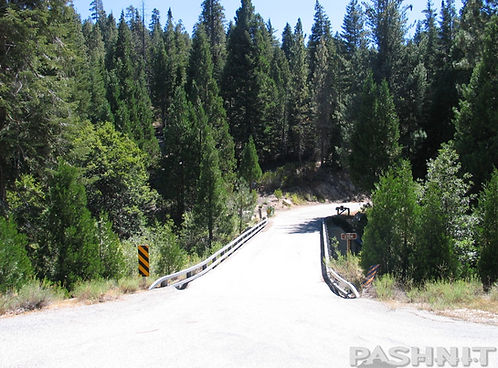
As it turns out for northbound riders, left (or west) was the proper choice, and I quickly dropped to Highway 190 only 2 miles away past some campers. Later checking an actual map, it labeled this short leg as Forest Road 23S02, but the actual sign pictured below (with appropriate bullet holes) labeled it as Forest Road 23S16- which was the very first sign that actually labeled the road for the entire time I was on it.

There was a sense of satisfaction when this road ended. I'd reached the main highway, back on the map, so to speak. Not lost anymore. Most of all, I'd gotten through unscathed. Granted my choice of motorcycle is probably something you won't see at this extreme level of back road, but the bike did just fine as yours likely will also.
Rides like this aren't suited for most motorcyclists, and the difficulty level would be placed at 'very high' if asked. Plus, FR23S16 bore a striking similarity to the much-vaunted Forest Road 1 (South Fork Mtn Rd / Titlow Hill Rd) in Northwestern California, which also rides atop a mountainous ridgeline with views that extend in either direction for 30-some miles. Much like Forest Rd 1, FR 23S16 connects the highways of Mountain Road 50 and Highway 190 & Highway 155 to the south.

FR 23S16 was unique in the many forest road choices that crisscross all the Sierra Nevada, for one, it was paved. That alone was unique in a world of endless forest roads in this region. It was passable by any size motorcycle, although some bikes will have to ride very gingerly. Pashnit Tour participants have ridden this two-up on a Harley Ultra Classic (not recommended) on down to all manner of sportbike. You'll need a sense of adventure, and don't leave home without a good zoom lens too, maybe even a set of binoculars as you can often see all the way to the bottom of the canyon 3000 feet below. Maps are optional.

Sometimes in my many years of wandering travels, I find something that impresses an indelible mark. A ride you're still thinking about a year later. Would I go back? I have many times plus I built this road into several Pashnit Tours, possibly because of an appreciation of all types of roads and rides, not just the ones dripping in salacious curves.
Over the years, as your curiosity grows and the need to discover new places continues to drive your pursuit of far-flung places, you may just find yourself on a road so remote and out of the way, it hasn't even been named yet.
Next Road?
Sherman Pass Rd or Highway 190 Western Divide Highway or over Parker Pass Mountain Rd 50 into Apocalypse Valley (it's not really called that).
Forest Road 23S16 - Photo Gallery


Maps
MORE INFO: Forest Road 23S16
RIDE IT on a PASHNIT TOUR
25 Miles - LENGTH
Poor, unused, dirty, lots of sand - PAVEMENT
Slow, narrow, always sandy- CURVES
Posey to Hwy 190 Western Divide Hwy - CONNECTS
Kernville, Ducor, Bakersfield- GAS
7280 ft - Portuguese Pass ELEVATION
Portuguese Pass - MOUNTAIN PASS
See below - GPS LOCATION


Nearby Motorcycle Roads:
Where to Next?
Northbound: Continue the frivolity with Highway 190 - Western Divide Hwy. Be sure to stop at the summit to see the Giant Sequoias, then get ready for the twistiest ride of your life around Cedar Slope!
Southbound: If you happen to find yourself headed southbound on Rd 23S16, you can ride all the way through to Hwy 155 via dirt fire roads. And then down into the Central Valley, or towards Lake Isabella.
Eastbound: Long for more adventure? Backroad getaways? Than ride this & then head through Johnsondale and ride Sherman Pass to Kennedy Meadows. Not much up there, but a whole lot of space. Just what the doctor ordered.
Westbound: Rd 23S16 overlooks the entire Central Valley, but one of the funnest roads I've ever ridden is Old Stage Rd at Posey, aka at Mountain Rd 109. Find it on the map, and ride it! Bit goaty, but great fun! Also note that if you are traveling northbound to Highway 190, at the summit headed southeast is Parker Pass Rd headed back down into the Central Valley via Hot Springs Rd which one of this regions great motorcycle roads!
3-D Imaging of Forest Road 23S16


Satellite Mapping of Forest Road 23S16


Interactive Mapping of Forest Road 23S16