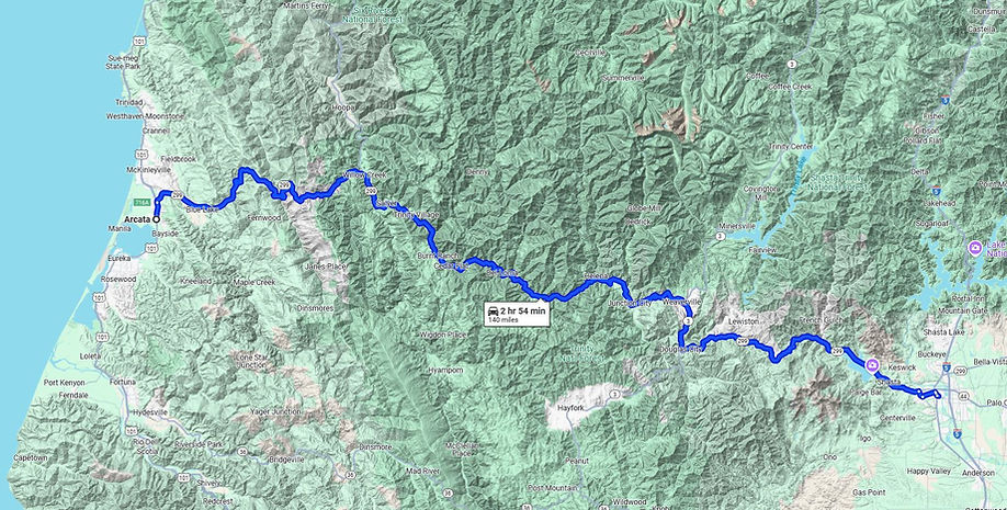
Trinity River, Northern California

Trinity County, CA
137 Miles - LENGTH
Shasta, Trinity, Humboldt - COUNTY
Redding, Weaverville, Willow Creek - GAS

Highway 299
HIGHLIGHTS
French Gulch
Whiskeytown Falls Trinity Mountain Rd
Trinity Dam Rd / Old Lewiston Rd
Hwy 3 - Hayfork Pass
Weaverville
Joss House Chinese Temple
Hydraulic Mining History
Underwood Mountain Rd - FR60
Burnt Ranch
Willow Creek
Bigfoot Museum
Highway 96
Forest Rd 1 - Titlow Hill Rd
Highway 299 - East side of state
Trinity Scenic Byway
You know that feeling you have after a long day on the motorcycle? The right hand is a little sore, the back too. You took ibuprofen an hour before reaching your stop for the night, so it kicks in when you get off the bike. Your body feels like it spent a day in the saddle, muscles ache and movements are a little slow at first upon arrival at your destination. Even though the bike is parked, it feels like you're still moving, the vibration and sound of the bike still resonate in your ears. The endless landscapes you've seen today play over and over in your mind’s eye. Yet, the day ends with an incredible sense of satisfaction. And this is a feeling you wouldn't trade for the world. You've ridden into a relaxed state of tranquil serenity. Today was a good day.


Motorcycle Zen
Highway 299 offers up a dose of motorcycling at its best. And it does so with a gamete of variety. Much of the ride runs right through the middle of Six Rivers, Trinity, and Shasta National Forests.
While Hwy 299 is one of the longest signed highways in the state running from the Nevada border clear across the state to the Pacific Ocean, from the motorcyclist’s perspective, we’ll focus on the western half of the state riding Interstate 5 at Redding out to the ocean. There are three east-west options in the far-northwestern reaches of California. Highway 96 runs closest to the Oregon border, Highway 299 runs in the middle, and much-loved Highway 36 makes up the southern option. The next east-west road is far to the south of Highway 20 across the top of Clear Lake. Everything in-between Highway 20 & 36, a stretch of land 75 miles north-to-south and 100 miles wide, is nearly all wilderness with few paved roads dominated by the Mendocino National Forest.
Beginning from Interstate 5, the eastern portion of this ride from Redding to Weaverville is an efficient and fast ride, at first headed for the Whiskeytown Reservoir completed in the 1960s. This region can be very hot in summer months, with average temps near 100 degrees. One of the hottest days in Northern California was recorded here in 1949 at 120 degrees near Whiskeytown Reservoir. On the west side of the reservoir is Trinity Mountain Road up through French Gulch along the banks of Clear Creek. Trinity Mountain Rd is paved (albeit progressively worse) for about 16 miles in.
French Gulch, 3 miles north of Hwy 299 and 19 miles west of Redding, was built up by French Canadians in the first wave of miners. Placer gold was so plentiful along the banks of Clear Creek, claims were limited to 10 feet of river edge per miner. French Gulch at one time was the western terminus of the California Trail. The California Trail started in western Missouri and stretched across the Great Plains for a total length of 1950 miles, which people walked, in leather shoes, and was most heavily used during the 1840s through 1860s until the Transcontinental Railroad turned a four-month-long journey into three days. A train ticket to California was $69, approximately $2,288 in today's dollars, for 'emigrant' class, basically a bench. The California Trail originally headed for Sacramento and Sutters Fort, but had many branches and cutoffs, including one to French Gulch.
The Washington Mine at French Gulch was the first lode (gold in hard rock) mine worked in Shasta County. In 1856, a piece of hard rock ore was found containing two pounds of gold, worth $53,000 in today’s dollars. Between 1900 and 1914, the French Gulch region was mining up to $500,000 worth of gold, each year, while four separate hard rock mines were crushing gold-bearing quartz rock using a stamp mill (below). At the Gladstone mine, thirty stamps were active. Over $30 million in gold was mined around French Gulch, and today several hundred residents call this remote valley home.

Two miles east of the French Gulch turnoff north at Trinity Mountain Rd is Crystal Creek Rd across a modern concrete bridge headed south over the Trinity River. There is a sign for Whiskeytown Falls as there are two waterfalls to check out. The Crystal Creek Falls Trailhead is located two miles south (paved road) of Hwy 299 to the Crystal Creek Waterfall, which has a total height of about 52 feet. The walking path is paved for the 1/3 mile to the falls. There’s also a small swimming hole at the base of the falls.
Highway 299 is also the main thoroughfare for trucking, and of the three main east-west roads in Northern California, Highway 36, Highway 299, and Highway 96, this is the trucking route for large trucks and campers. Both should stay off Highway 36 & Highway 96. Note that also means boat traffic on late Sunday afternoon headed back to Interstate 5.
West of Trinity Mountain Road, the curves begin up to the 3626 ft. Buckhorn Summit which CalTrans has recently widened, rebuilt, re-carved, and repaved this uphill stretch.

Nearing Weaverville, Trinity Dam Blvd & Old Lewiston Rd both head north from Highway 299. Both have pleasingly curvy pavement. Old Lewiston Rd is longer, with more twists near the Trinity River. Both join up in Lewiston to connect north to Highway 3 at Trinity Lake towards Yreka. There is a single gas station in Lewiston. These two also make a twisty shortcut around Weaverville. Note Rush Creek Rd is a quick shortcut over to the east side of Weaverville. Steel Bridge Rd looks interesting as Hwy 299 meets up with the Trinity River, but this is a dead end to Steel Bridge Campground.
Lewis’ Town / Lewiston
Forty-niner Thomas Palmer bought Cephus Wood’s property known as “Old Tucker’s Place” in 1850. In 1851, he built a ferry, a bridge, and numerous buildings. Palmer hired his adopted son, Benjamin Franklin Lewis to run his enterprises, known to many as Lewis’ Bridge Estates, called Lewiston. Palmer died in 1853, leaving the entire 320 acres on the river including improvements, to B.F. Lewis. Lewis lost a lawsuit in February 1855 to Palmer’s former associates and was forced to sell out. In 1856, Lewis married an English woman named Mary, in Sacramento, CA. They had three children, Elvira, Frank P. and Remania. The Lewis’ lived in many locations. Mary died in 1878 in Lakeview. OR. The man who gave Lewiston its name was known to all as a solid citizen of upstanding character. B.F. Lewis died of natural causes Sept. 28, 1900 in Dalles, Oregon.

The ride relaxes once it reaches the turnoff for Highway 3 Hayfork Pass. Southward will take you up and over twisty Hayfork Pass, past the super-fun Wildwood Road, to the small town of Hayfork and on to Highway 36. Also take note of Hyampom Rd in the middle of Hayfork flowing west to Hyampom. It looks like a dead end, but technically is not. This road does connect back north to Hwy 299 up and over the range, but it’s a single lane paved (mostly) fire road up and over the range and loved by ADV riders. This connects back to Hwy 299 on the west side of Salyer as Forest Road 447. More details on the Highway 3 Hayfork Pass page.
Northward on a steady uphill will take you into Weaverville. There is a Rest Area a mile west of the Highway 3 turnoff to Hayfork on the south side of the road. Highway 3 & 299 are combined in this short section of highway over to Weaverville where Highway 3 will continue north to the Scott Mountain Summit and on to Yreka.

Weaverville oozes tranquil, peaceful, historic and lacking the tourist feel. The town is named after one of three men who discovered gold here in 1850- they drew lots for the name- and Mr. Weaver won
Very little has changed since then. The same buildings still stand, some are the oldest continually used buildings in the state. The courthouse is the second oldest in California, dating to 1856. The Weaverville Drug Store is the oldest in California, dating to 1852 and is included in the Register of Historic California Businesses. The drug store has been operated by the same family since 1941. Still open. Weaverville downtown is also known for its spiral staircases. There are two, one on each side of Main Street, leading up to 2nd floor balconies that overlook Main Street.
Several good restaurants here we use for lunch with tour groups are at the Highway 3 & Highway 299 junction. Park at the spiral staircases and walk to Mama Llama for good eats. Comic book covers and posters adorn the inside walls, and you’ll be able to catch up on your Spider-Man plot lines. Hint, Spider-Man wins.
The Joss House, built in 1874, is a Taoist Temple that’s regarded as the best-preserved Gold Rush-era Chinese place of worship. The temple, located in the center of town, is a must-visit. Over 2000 Chinese gold miners lived here in Weaverville in their own Chinatown during the Gold Rush.

These immigrants were farmers from the southeastern provinces of China. A devastating flood in 1849, famine, political rebellion, and the terror of war paralyzed agriculture and industry in the region. Thousands were forced to move to the port city of Canton. It was here they first heard the news of gold in the mountains of California.
Chinese immigrants during the late 1840s poured into California. They mined the discarded tailings of gold mines, built 700 miles of levees in the Sacramento River Delta, and helped build the Transcontinental Railroad. A docent will lead you into the temple and explain the ornate altar inside. There are other preserved Taoist Temples in Mendocino and Yuba City, but the Joss House is easily accessible and a fascinating slice of Gold Rush history.


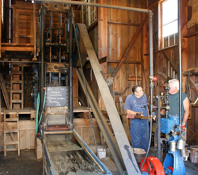
A hundred feet south of the Joss House is the Jake Jackson Museum. The museum grounds have the Paymaster Stamp Mill, a replica holding a working steam-powered Stamp Mill, the only one on the West Coast. While there are other Stamp Mills spread around the northern portion of the state, often in museums or small-town parks, this one you can view in operation. Other exhibits are a working blacksmith shop with locals hammering away and a working sawmill. Worthy reasons to pause your journey and check out these unique displays.
About 4000 people call Weaverville home and the Trinity River Lumber sawmill, located in the middle of town, is the largest private employer in Weaverville. It is still active, even though the vast majority of California sawmills shut down in the 1990s.
In the middle of Weaverville is the intersection with Highway 3 continuing north. Eleven miles north along Highway 3 is Trinity Lake, aka Clair Engle Lake, home of a restored bald eagle population along 140 miles of shoreline. This is a large lake, the third-largest man-made reservoir in California, completed in the 1950s reservoir building boom.
In 2014, a wildfire erupted west of town and burned the forest to within 2 miles of town. As you leave Weaverville, the burn scar on both sides of Highway 299 is still there.
In 2017, the Helena Wildfire erupted at Helena, ten miles to the west of Weaverville along Highway 299 after a tree came down on a power-line. The wildfire burned 20,000 acres eastward up the range toward Weaverville, but was contained without threatening the town. During the heat of summer, this can be a very dry area and rain in summer is very rare.
Weaverville sits at an elevation of 2000 feet but is surrounded by mountain tops often sporting snow-capped peaks into April. Monument Peak to the northwest rises to 7771 feet, while nearby peaks north of Hwy 299 are Sawtooth Mountain 8886 ft, and Mount Hilton 8964 ft. Motivated hikers can take roads north from this portion of Hwy 299 to trailheads. At Junction City, split north on Canyon Creek Rd 13.2 miles to the Canyon Creek Trailhead.
It's another 95 miles of motorcycle bliss to US 101 on the Pacific Coast, so make sure you top off the tank in Weaverville. While there are no major towns west of Weaverville, this is actually a rather busy road. Especially with RV's tooling along and semi's hauling lumber or wood chips. As for all of northwestern California, this is the main road from the Central Valley to the Pacific Coast.

Westward bound out of Weaverville takes you steadily up to the 2888 ft. Oregon Mountain Summit. There is an overlook here where you can gaze down on Weaverville and try to imagine what it looked like 150 years ago, as this was the center of the gold mining population. There is an original hydraulic monitor at the crest of the road, used from 1851 until 1939.
A plaque about the LaGrange Gold Mine reads: This mine originally known as the Oregon Mountain Group of claims first operated about 1862. In 1892 the mine was purchased by the LaGrange Hydraulic Gold Mining Company which brought water from Stuart's Fork through 29 miles of ditch tunnels and flume and delivered it to the mine pit under a 650-foot head. Over 100,000,000 yards of gravel were moved and $3,500,000 in gold produced. Large scale operations ceased in 1918.


The amount of water needed with hydraulic mining was enormous. At the North Bloomfield mine for example at Malakoff Diggins near Nevada City, sixty million gallons of water was used daily in their hydraulic mining operation. To visualize that, 1 million gallons of water would form a cube that is about 50 feet on each side & 5 stories high, now visualize 60 of those cubes used each day.
The La Grange mine opened up in 1851 and became another large-scale open pit mine, much like Malakoff Diggins. So much soil was washed away- it totaled the equivalent of 6 football fields, 2 miles high. 90% of the mountain was washed away down the Trinity River by numerous monitors working day and night. According to the sign, this was the largest hydraulic mine in the world.
When the mine closed in 1918 due to WWI, the California Department of Transportation showed up and started the monitors right back up again. The goal, though, was tourism- to link the central valley with the Pacific coast. It took another 5 years of working day and night by CalTrans to make the road cut with the monitors. In 1939, this last portion of Highway 299 was completed.
Weaverville to Willow Creek is an enjoyable 56-mile dead run. The pavement is smooth, wide, with often long-distance see-through, corners can last several miles much like Highway 96 to the north as Hwy 299 joins up with the Trinity River following the contours of the river. The majority of this leg is a steady downhill as you ride westward from Junction City, el. 1909’ to Willow Creek at el. 610’ with no major roads splitting off from this stretch of Hwy 299.
The road through this canyon was one of the last major roads to be built in California. Lack of funds led the federal government to use prison labor from San Quentin in San Francisco and Folsom State Prison near Sacramento. Convicts blasted through solid rock, dug ditches, and diligently toiled to build a road between the Redwood Coast and the Central Valley.
Up until the 1960s, the water below the road was a mere trickle in fall, and a raging torrent in spring. Now with the Trinity Lake & Dam, water flows are steady year-round- ranging from Class II, up to Class V rapids. Great for whitewater rafting, kayaking, or even an inner tube ride. Not to mention the anglers with fly rods. The vast watershed of the Trinity River drains out of the Shasta, Trinity and Six Rivers National Forests.

The road ranges from just above the river surface to climbing the canyon wall. The terrain is rugged, and untouched. The pavement overall is excellent, although there is always construction somewhere along this stretch as CalTrans endeavors to keep the road open.
The curves never end. One after the other. No matter what type of motorcycle you ride- or what your riding style, this is The Joy of Riding.

I found this to be one of the most enjoyable motorcycle rides I've had in years of riding around California, and was impressed by this section of road far more than I anticipated. A harmony of sorts is achieved, of rider and machine flowing effortlessly though the curves. There are smooth curves and tighter corners thrown into the ride in the Six Rivers National Forest portion.
While I can deal with the traffic, the lack of major centers of populace allows this motorcycle ride to retain that away-from-it-all feeling. There is plenty of room to pass and plenty of pullouts for the majority of the road.

After Cedar Flat, the road switches to the south side of the river and the canyon narrows as the road climbs higher up the side of the canyon and heads into the Six Rivers National Forest. Some tighter turns here on newer pavement. North of Burnt Ranch, the New River flows out of a canyon and contributes its watershed to the Trinity River. The New River Canyon is visible to the north of the road.
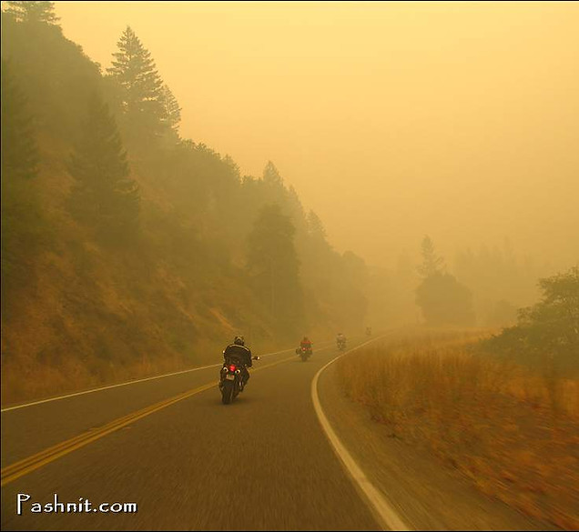
The usual hazards along the banks of the river, rocks especially from the continuously steep road cut, and even pine cones which can be like rocks if you hit one. The pine cones can grow as large as 12 inches. Deer, bears and ice/snow in winter can also be expected. Weather will vary throughout the year, the elevation isn't high enough to expect snow (it is rare) but winter rains can be heavy. Summers will be hot and dry, with 90-100 degree temps in the canyon commonplace. Bring a cool vest if you ride this region in summer. Keep in mind that the Trinity Alps Wilderness to the north is the second-largest wilderness area in the state.

Burnt Ranch Photo
A few years ago, twenty or so, I came across a photo of a delicious set of S-curves. So intrigued with‘where is that’ curiosity, I messaged the poster and got a reply, Burnt Ranch. That photo stuck with me for many years, so much so, years later I would go to the exact spot to try and replicate the photo I had seen 20 years earlier. As luck would have it; that portion of Hwy 99 was recently repaved. This set of S-curves is located a short distance west of Burnt Ranch. Burnt Ranch is a former important mining center that had a post office as early as 1858, was so named because Canadian miners burned down an Indian rancheria in 1849. The often-told story of the Indians burning down a settler's ranch there is purely imaginative.
Hwy 299 enters the Shasta-Trinity National Forest west of Burnt Ranch, a 2,210,485 acre wilderness region that includes hundreds of mountain lakes and, 6278 miles of streams and rivers.
On the western edge of Burnt Ranch is Forest Road 60, aka Underwood Mountain Rd. This forest road is paved, albeit poorly, and it's worth mentioning as it's the only paved road up and over Underwood Mountain that reaches Hyampom 27 miles distant on the other side of the range.
At Salyer, Hwy 299 crosses back and forth over the Trinity River several times, and homes along the highway begin to increase as Willow Creek draws near. Numerous campgrounds in this stretch offer respite from traveling for those that don’t prefer a roof.

Finally reaching Willow Creek an hour after leaving Weaverville, top off on fuel and check out the Bigfoot Museum in town. While the museum includes static displays of equipment outside including a 14-ft tall chainsaw carving of the elusive creature, inside a separate room is designated solely for Bigfoot memorabilia. From board games, books and assorted plaster casts of footprints the creature has left behind, the museum is a worthy stop. The Willow Creek - China Flat Museum is usually open May through October.
Willow Creek is small, but the largest town for a 30-mile radius. The junction of Hwy 299 and Highway 96 is here. Combined with 299, Highway 96 makes a complete loop and jettisons you at Yreka near the Oregon border. Access to Bald Hills Rd via Hwy 169 at Weitchpec is the only road that connects to anything along Highway 96 other than the Forks of Salmon and Happy Camp Rd.
West of Willow Creek, Highway 299 climbs up to the 2859 ft. Berry Summit, past Titlow Hill Road - South Fork Mountain Rd through a fast set of curves. On the west side of the summit is a Vista Point to take a break to enjoy the view of the river canyon below. Rolling into Humboldt County, the terrain is changing, getting closer to the ocean. The dry climate back near Weaverville is evolving to lusher and more green meadow open areas.
West of the Vista Point at the summit, flow down through a terrific 180-degree hairpin to Redwood Creek, which drains the Redwood National Park to the north, then right back up again to the 2262 ft. Lord-Ellis Summit (aka Redwood Summit). It's a relaxing ride westward to the coast, and the road converts to a four-lane highway to Blue Lake at the base of the range.
Note, you can head south from Blue Lake on (paved) Maple Creek Rd through Kneeland for a remote backroad ride into the east side of Eureka. Kneeland Rd continues due south but is 20 miles of dirt connecting to Highway 36 at Bridgeville.

Being closer to the Pacific Coast also means a dramatic change in temperature, especially on hot summer days as one nears the ocean. Thick fog may also be experienced in this stretch, usually dissipating at the summit.
We have ridden the ascent eastbound up to the Lord-Ellis Summit in ocean fog so thick, we couldn't see anything. Cresting over the range, the tour group burst out of the fog and into blue, sunny skies. This is a long and enjoyable ride – Interstate 5 to Hwy 101 is 126 miles – pavement is generally excellent throughout and if you desire a twisty ride through NorCal to get you out to the coast quickly and efficiently, this is the best option. It's not the twistiest, it's not the most deserted, but it is a very enjoyable ride for any rider. Hwy 299 is one of the longer single-segment roads in the state, well worth the effort to get yourself to this road and ride along the edge of the Trinity River Canyon.

Highway 299 East of Interstate 5
Highway 299 on the eastern half of Northern California heads clear across the state to the Nevada border, but this is a true highway, fast, straight, nondescript, point A to point B across a volcanic plain bordered by Mount Lassen to the south, and Mount Shasta to the north. By mindful of gas and range anytime venturing into more remote regions of Northern California. The one thing worth mentioning is Fall River Mills has a quick little detour past an ‘art sculpture display’ along Cassel Rd at the Parkway Materials Sculpture Park. Roadside art is always worth a detour. There’s a flying beetle made from a VW Beetle, a giant Brontosaurus made from a concrete truck mixer. (right) Punch in 22244 Cassel Rd, Cassel, CA and go check it out..
A quick hint for the motorcyclist is continue south to Cassel and pick up Cassel Fall River Rd to Fall River. This detour parallels the main highway and connects Cassel with Fall River Mills. This detour is twisty, scenic, and has some fast twisty curves dipping briefly into the Lassen National Forest.
Also take note of McArthur Burney Falls (below) along Highway 89 due north of Hwy 299. Although reaching this massive waterfall can only be done via long, straight roads, it is well worth the visit. Especially on hot summer days, when the temperatures are 20 degrees cooler at the river bottom than the parking lot above. Burney Falls is even more fascinating when you learn there's no major river feeding this waterfall, water is shooting out of the ground. Hwy 44 connects back south over Mount Lassen back to Highway 36 near Childs Meadow.
Last Words:
Highway 299 pales next to its neighbors of Highway 36 and Highway 96. It’s busy, there is more traffic. More trucks, RVs, etc. But that’s not the point. Given a choice, you’d choose one of the other rides if you were in no hurry and out for a leisure motorcycle ride. Last time I took Highway 299, I had to get from the coast inland to I-5 to head into the Central Valley. And Highway 299 is the quickest option, still a fun ride, and fast. Don’t cross it off your list so quick.

Cassel-Fall River Rd
Cassel-Fall River Rd is one of those blink-and-you-miss-it connectors that quietly delivers everything a motorcyclist wants. Tucked into the far northeast corner of California between the tiny hamlets of Cassel and Fall River Mills, (about 70 miles northeast of Redding, CA) this ribbon of pavement traces the edge of the Fall River Valley. It sits beneath the looming presence of Mount Shasta 60 miles to the northwest and the timbered slopes of the southern Cascades to the east.
It’s not famous. It’s not crowded. And that’s exactly the point. Like many of the best unknown rides copiously documented on Pashnit.com, it parallels a major route—Highway 299—offering a serene alternative to the main slab.
What makes this road truly unique is the foundation beneath your tires. The route literally flows up and over ancient basaltic lava flows from the Modoc Plateau. These weren't explosive eruptions; they were massive, fluid sheets of liquid rock that cooled into a naturally undulating tableland. The result for the rider is a series of gentle, rhythmic rises and falls that follow the prehistoric contours of the stone.
Originally built to serve ranching and the early 20th-century hydroelectric developments along the Pit River system, the road was engineered as a practical rural connector across this volcanic crust. What that left behind is smooth, flowing pavement with open sight lines and virtually zero traffic.
There is a hidden world beneath this pavement. The porous volcanic rock acts like a massive subterranean sponge, holding millions of gallons of snowmelt from the peaks above. As you ride, an entire river system is flowing silently beneath you through a labyrinth of lava tubes and fractured basalt. This icy water eventually "bursts" from the earth just a few miles away, feeding the nearby spectacular 129-foot drop of Burney Falls—often called the eighth wonder of the world.
This isn’t a white-knuckle technical assault; it’s rhythm riding. Think S-curves, big sky, and deep green irrigated fields fed by one of the largest spring-fed river systems in the country. These are long, graceful bends where you can settle into a pace and just breathe.

Cassel-Fall River Rd
As a major bonus, Cassel-Fall River Road was recently repaved. It’s not crawling with tourists; it’s just smooth delight—remote, quiet, and pulse-settling. Ride it in the early morning when the sun hits the Cascades and Mount Shasta is glowing pink in the distance, and you’ll understand exactly why we go the long way anytime our Pashnit Motorcycle Tours groups are riding this remote region of California.
When you reach Fall River Mills, aim for the historic Fall River Mills Hotel for good eats, and top off fuel at the Bullets & Booze Gas Station just around the corner. (yes, it’s a real place).
.jpg)
Cassel-Fall River Rd parallels Highway 299
Last Words:
Highway 299 pales next to its neighbors of Highway 36 and Highway 96. It’s busy, there is more traffic. More trucks, RVs, etc. But that’s not the point. Given a choice, you’d choose one of the other rides if you were in no hurry and out for a leisure motorcycle ride. Last time I took Highway 299, I had to get from the coast inland to I-5 to head into the Central Valley. And Highway 299 is the quickest option, still a fun ride, and fast. Don’t cross it off your list so quick.
And if you make i tover to the eastern side of California, be sure to check out Burney Falls, Cassel-Fall River Mills, and the Bullets & Booze Gas Station. The only thing missing from that sign is 'Divorce'.


McArthur-Burney Falls six miles north of Burney is a must-visit place
Where to next?
South at Hwy 101 from Arcata: Remember that The Lost Coast - Mattole Road & the Avenue of Giants are only a few miles south of this junction of 299 & 101. Due east of Mattole Rd is Highway 36 for a large loop. Highway 299, Highway 36 & Highway 3 make an excellence all-day loop.
North at Hwy 101 takes you to Trinidad and outside Orick is Bald Hills Rd. Next is the Oregon border. Note Hwy 199 is a quick diagonal connector into Oregon and be connected with Happy Camp Rd to Highway 96 for a loop back into California. At Trinidad is Patricks Point Dr right along the ocean, ride that if headed along Hwy 101.
Highway 3 South at Douglas City: One of our favorite loops when based from Fortuna/Eureka. Make south on Highway 3 over Hayfork Pass over to Highway 36. Or... Head east on Highway 36 from Fortuna, ride past South Fork Mountain Rd, Explore Horse Ridge Lookout, then at The Triangle, head north on Hwy 3 Hayfork Pass and back around on Highway 299 back out the ocean for an all day loop. Note this loop can be modified with South Fork Mountain Rd.
Highway 3 North at Weaverville continues Highway 3 north to Trinity Lake, up over Scott Mountain Summit to Gazelle Callahan Rd, through Callahan, past the Forks of Salmon, then Quartz Valley Rd to Scott River Rd over to Highway 96. Hwy 3 North continues all the way to Yreka. Awesome day of riding. At Callahan is the south leg of the Forks of Salmon. We call the south fork The Racetrack, ride it and see why we call it that.
Highway 299 - Photo Gallery


MORE INFO: Highway 299
RIDE IT on a PASHNIT TOUR
137 Miles - LENGTH
Very good, smooth, major highway - PAVEMENT
Steady & Smooth, Constant - CURVES
Redding, Weaverville, Willow Creek - GAS
Redding, Weaverville, Willow Creek, Arcata - LODGING
GPS LOCATION
- Redding
Arcata
LISTED CONNECTING SIDEROADS:
Trinity Mountain Rd
Trinity Dam Blvd
Old Lewiston Rd
Highway 3 - Hayfork Pass
Forest Rd 477 at Salyer
Highway 96
Forest Road 1 - Titlow Hill Rd


Topo Maps