Sierra Nevada Range, California

Alpine County, California
Highway 4
Calaveras, Alpine - COUNTY
23-miles of single-line-no-center-line, state highway - PAVEMENT
Numerous, hairpins, steep grades to 24% - CURVES
Arnold, Bear Valley, Markleeville - GAS

Quick Ride: Sierra Nevada mountain pass much loved by riders with super-fun one-lane section at the summit. Very steep grades and connects to Highway 89 Monitor Pass.
Makes the perfect loop when combined with Highway 108-Sonora Pass.
Riding Ebbetts Pass
HIGHLIGHTS
Rock Creek Rd
Parrots Ferry Rd
Six Mile Rd
Murphys
Sheep Ranch
Arnold
Pacific Grade Summit
Hermit Valley
Ebbetts Pass
Pacific Crest Trail
Silver Mountain City
Scossa's Cow Camp
Maps / Comments
Name something that is your favorite.
Favorite ice cream, favorite tire, set of lucky gloves, your favorite mountain pass perhaps? For motorcyclists that have the Sierra Nevada range in their backyard, this will always be a source of contention, of debate.
A few years ago, some riders developed a rating system for roads to rank them from best to not so best. They added in all the pertinent mathematical formulas, twistiness, pavement, engineering, scenery, remoteness and finally, character. In the end, they compared them all, added up the mathematical score and came out with a clear winner. The authors named Highway 89 Monitor Pass as the best motorcycle road in the state of California. Riders were either pleased or surprised. What about Road X, or Road Y? Those are better. I have to admit that as a connoisseur of roads for motorcyclists, I never wanted to create a rating system for roads. Which is why this site has never had anything like that in the last 20 years. Read the description, absorb the photos, glue the legs together in your journey. You decide. Who am I to say what type of road you’ll like? I have no idea. That’s your job.

But what I do know is you are going to love Highway 4 Ebbetts Pass. I can say that with conviction because in 20 years of running motorcycle tours across Ebbetts Pass, I’ve never met a motorcyclist that didn’t fall in love with this road.
As one of the last of a dying breed of road, the no-center-line-single-lane rides are being paved over and carved up in the name of progress, there aren’t many single lane roads left, Highway 36 was another famous stretch of road that had a stretch of no-center-line-single-lane between Mad River and Bridgeville. It’s all been taken out, the tight curves smoothed over and removed.
From the motorcyclist’s perspective, a moment of silence should be observed for our beloved Highway 36. But multiply that much-loved 5-mile stretch Highway 36 used to have – past tense – by a factor of four, and you have the wondrous stretch of pavement in the Sierra Nevada Range that even includes two summits, Pacific Grade and Ebbetts.
Come ride this before some yahoo in a board room who’s never even seen the road decides it’s time to carve up our beloved Highway 4. Ridden eastbound, Ebbetts Pass starts off in Stockton in the Central Valley with long straights to escape the farmland behind you, rising from the valley floor into a twisty thrill as you near Highway 49. If you want to reach Knights Ferry Covered Bridge built in 1863, head south on Milton Rd–Highway J14 to Sonora Rd.
Highway 4 passes near Copperopolis where 19 million pounds of copper were mined in the 1860s. By 1946, they had produced 72,598,883 pounds of copper worth over $12 million, over $160 million in today's dollars. There is fuel here at Copperopolis.
Take note of O’Byrnes Ferry Rd to the south, which extends across the top of Lake Tulloch. If you're headed south, continue with La Grange Rd to Snelling Rd into Merced. Riding northbound out of the Central Valley: the Snelling-La Grange –O’Byrnes Ferry combo provides an escape off the valley floor into the foothills while paralleling both the Highway 99 freeway and Highway 49 which translates to a lot less traffic on this combo.

La Grange Rd is a wide-fast north-south connector that will keep you off the Highway 99 freeway.

Rock Creek Rd connects Copperopolis past Salt Spring Reservoir with Milton.
Rock Creek Rd extends north from Copperopolis, but quickly degrades to a single lane, bumpy & patched back road to Salt Spring Valley Reservoir. This small reservoir is a forgotten fishing spot and may hold a few small boats. Rock Creek Road is paved for the duration over to Milton, but is extremely bumpy and patched.
Copperopolis is also where the Sierra Foothills begin. The Sierra Foothills are an elevation band that contain a plethora of roads between the 1000–4000 foot elevation band that becomes an endless list of roads this site will focus on over the coming years. The nearby Little Dragon is likely the poster child for foothill roads. Whenever you’re ready to explore these roads, you’ll spend years crossing them off. There are many left-over from 1850s Gold Rush Days when mining camps were connected by a spider web of roads with boomtowns at every intersection. These were walking paths, then horse trails, then wagon roads, then pavement was laid over these wagon roads. Then one day you showed up on your motorcycle.

Milton Rd connects through the Sierra Foothills to Highway 4, always deserted, zero traffic and the middle of nowhere.
East of Copperopolis six miles on the hilltop is Pool Station Rd connecting over to San Andreas. A much better parallel alternative to the busy Highway 49, Pool Station Rd is spirited fun and the Part III southern leg of my Holy Grail Triad in this region. Sutter-Ione Rd makes of the northern leg (Part I) of the Holy Grail, and Stony Creek Rd (Part II) is the middle. Another day, we’re here to ride Highway 4 over the Sierra Range.
In Angels Camp, this is the town immortalized by Mark Twain in his book The Celebrated Jumping Frog of Calaveras County. Twain wrote the short story in 1865 at the age of 30 that was originally published in The Saturday Press, a weekly literary newspaper. The colorful short story proved so popular, it was re-published many times over, helping Twain gain notoriety as a writer.
Author Bret Harte also used Angels Camp as the setting for his book The Luck of Roaring Camp published in 1868. The story proved so popular, it was first made into a film in 1910 and another five film adaptions were made all the way to 1981.
Angels Camp also sat atop a massive vein of gold that extended east out of town to the southern edge of Altaville. Hard Rock mines were developed and at their peak, over 200 stamps operated day and night to crush the quartz rock that was contained in the veins of gold beneath the town.

Highway 49 The Little Dragon is the poster child for thrilling twisty Sierra Foothill roads.
Five mines operated here producing a total of over $20 million in gold during the 1880s and 1890s. This area is also rife with great roads if you want to poke around a bit. Highway 49 averages an elevation of 1500-2000 feet, and above the 2000 ft mark, the local roads run mostly up the valleys or along the ridges headed into the mountains. Intersecting Highway 49 northwest of town, Highway 4 and Highway 49 join for several miles onto a new bypass that circles around Angels Camp to the east and continues as Highway 4.
Highway 4 gains in elevation to Vallecito. Here is where Levi Strauss created the first pair of Levi's out of the canvas from his tent. Not everyone was searching for gold during the Gold Rush. Often the prospectors that truly struck gold were the merchants the supplied the miners. Prospectors that were convinced the next big strike was always under the next rock, or in the next pan of gravel, were willing to pay high prices for just about anything.

The gold rush town of Columbia has been turned into a state historic park.
Parrots Ferry Rd
Parrots Ferry Rd, east of Angles Camp, is a wide & fast favorite among motorcyclists as it heads on down the hill to New Melones Reservoir and back up to Columbia- a gold rush town that's been converted into a state park. Columbia SHP has become one of the best-preserved gold rush towns in the Foothills and is a delight to walk the streets. Perfect place for ice cream on a hot summer day. Yankee Hill Rd to Big Hill Rd to Middle Camp Rd outside of Columbia completes the connection back over to Hwy 108 at Sugar Pine and avoids all the residential traffic around the mountain communities of Twain Harte.
It's worth noting that Parrots Ferry Rd is always the western leg in our loop when riding Highway 4 and Highway 108 together as a day ride. Utilizing Parrots Ferry enables you to avoid having to use Highway 49, stays above the traffic and keeps you above the heat of summer. Riders try to avoid dropping below the 3000-foot mark, which bumps the temperature an easy 10 degrees. Dipping down into the heat of summer, 90-100 degree days are the norm below 2000 feet. That also means as you climb into the mountains out of Angels Camp, you’ll welcome the change in temperature. Bring the Cool Vest, and in spring-fall, bring the heated gear. While it may be warm here, it can be snowing over the summit on the right day. Worth mentioning with an elevation nearly to 9000 feet, Ebbetts Pass is always closed in winter, and generally opens up in late May. Note that elevation creates its own weather.
Six Mile Rd
At the Ironstone Vineyard Museum, you can check out the world's largest crystalline gold leaf, weighing in at 44 pounds. This is the largest specimen of crystalline gold in the world, amazingly, it wasn't discovered in 1850, but in 1992 nearby in Jamestown. The Kautz specimen is unique in that it is not only the largest mass of gold specimen found in California since the turn of the century, but it is also the largest specimen of crystallized gold in existence today. Of equal importance, it is gold in the rarest form – crystallized. It is said to be priceless in value. The Kautz gold specimen at 44 lbs. is the largest single piece of gold mined in North America since the 1880s. One pound of gold runs about $18,000 x 44 = a rock worth $792,000.
The Heritage Museum at Ironstone Vineyard is on Six Mile Rd which runs parallel to Highway 4 flowing uphill to Murphys. Six Mile Rd is single-lane goat trail with a brand-new stretch of pavement near the winery, all corners were covered in gravel and the goat section included a 100-yard stretch of gravel. The $800,000 hunk of gold is located at 1894 Six Mile Rd, Murphys, CA. And FYI, there are seven wineries surrounding Murphys within a mere four miles.
_JPG.jpg)
Parrots Ferry Bridge over New Melones Reservoir

Six Mile Rd near Ironstone Vineyard

Many Gold Rush-era buildings in historic Murphys
Murphys
Three blinks later, turn north off the highway into tiny Murphys. In the year 1848, brothers Daniel & John Murphy settled in the area. The region around present-day Murphys was one of the richest placer mining regions of California. Starting out with just a tent, it's thought they were millionaires by age 25. Check out the shops and the Murphy's Hotel, built in 1855. Mark Twain and even General Ulysses S. Grant stayed at the Murphys Hotel.
Main Street is short, tight and narrow. Find a place to park and walk the town. The historic Murphys Hotel anchors Main Street in the center of town. It can be a touristy town during peak times like summer weekends, but they have ice cream here.

Sheep Ranch Rd is famous for being one the goatiest paved roads in the Sierra Foothills. The goat section lasts for five miles.
Sheep Ranch Rd
Murphys is so tiny, it's two streets, Main Street, and behind that is Church Street. For the motorcyclist, it is also the location of Sheep Ranch Rd which is worth mentioning as it’s the only north-south paved connector to get over to Railroad Flat Rd, Highway 26, Volcano, and Highway 88, the next mountain pass. Riders use Sheep Ranch Rd due to the higher elevation and not having to drop all the way down to Highway 49 into the tourist traffic. Sheep Ranch Rd dumps onto Main Street in Murphys, but it’s marked by a tiny sign that’s easy to miss. It looks more like an alley between buildings in the middle of town.
If you miss the alley that actually is Sheep Ranch Rd, travel a few more yards and access Sheep Ranch via Church Street. If you miss the turnoff, you’ll find yourself on Murphys Grade Rd and headed right back where you started in Angels Camp. Sheep Ranch Rd is one of the bumpiest, most neglected roads in the foothills. The pavement for a five-mile stretch is 20 mph 1st and 2nd gear unless you’re on a dual sport. It’s super bumpy, repeatedly patched with patches on top of patches, and one of the worst road surfaces for 100 miles. There are so many patches on this road, you can see them from space via Google Earth. But it’s the only paved road. You have a choice of one. So deal with it. It’s not long, Sheep Ranch is a mere 8 miles away. The greatest of ironies is the pavement from Sheep Ranch over to Mountain Ranch Rd is fantastic- twisty, smooth, super fun ride.

Sheep Ranch isn't all goat, some portions are super twisty and fun!

Intersection with Sheep Ranch Rd and Avery Sheep Ranch Road near Murphys
Avery Sheep Ranch Rd
Avery Sheep Ranch Rd is worth mentioning as a shortcut between (you guessed it) Avery and Sheep Ranch. While the foothills are riddled with dirt roads that will confuse the smartest GPS, this is the only one that is paved. Single lane with pavement long neglected, Avery Sheep Ranch Rd is bumpy and requires a relaxed pace. But I have used it many times as a shortcut over to Sheep Ranch when riding downhill from Highway 4, and it avoids the tourist traffic in Murphys.
Note Fullen Rd parallels Avery Sheep Ranch Rd (& Highway 4) as a single-lane-paved road, the pavement is very poor and bumpy, but it rides atop a ridgeline that was logged a few years back with wide open views of The Foothills. Fullen Rd connects with Sheep Ranch Rd right 5 miles north of Murphys. It's my curiosity that leads me up these paths, I wonder where this goes?
Elevation and heat are always an issue in summer, the goal being to stay as high as you can for as long as you can. Every 4000 foot elevation change is a difference of nearly 10 degrees. 90-degree temps are laborious in full gear, but it’s better than 100+ degrees down on Highway 49.
Arnold
East of Murphys, there are several mountain communities on either side of the highway that provide feeder traffic onto the main highway. You’ll finally get past the magical 4000-foot mark at Arnold as you climb into the national forest where the temps in summer begin to noticeably drop and become more bearable. Arnold, a community of about 4000 people, is the final chance for gas. Arnold nearly burned to the ground in 2015 when the Butte Fire ravaged 70,000 acres and burned 500 homes to the northwest. Arnold escaped the fate of Paradise (2018 Camp Fire: 153,000 acres, 18,000 buildings burned and 85 dead) when the weather changed and winds blew the fire away from Arnold. There are a lot of homes here, but they are stuck back into the forest on a labyrinth of narrow mountain roads.
Sierra Nevada Logging Museum
At the Chevron station in Arnold, Dunbar Rd leads north to the Sierra Nevada Logging Museum, 1 mile away on the edge of White Pines Lake. The museum is located on the site of a former logging camp dating to 1938. There are signs for the museum on Highway 4 and again near White Pines Lake.
The museum has numerous static displays of large logging equipment plus the Shay Locomotive No. 4, the twin of Shay Locomotive No. 3 in Sonora near Highway 108. There is a third Shay locomotive at Railtown 1897 in Jamestown. The static displays make it worth visiting even if the museum is closed. There are also picnic tables along White Pines Lake that make this the perfect outdoor lunch stop.
During summer months, the museum is open afternoons Thursday – Sunday and by appointment in winter. Check their website for hours plus the date of their annual Logging Jamboree festival held each fall for the last 25 years at the museum.

Sierra Nevada Logging Museum in Arnold

Shay Locomotive No. 4, note the pistons and bevel gears on each wheel

Calaveras Big Trees SHP
A three-mile stretch of Highway 4 east of Arnold was recently re-carved and re-paved on up to Calaveras Big Trees State Park created in 1931. Calaveras Big Trees protects a collection of giant sierra redwoods discovered by hunter A.T. Dowd in 1852. The discovery of the world's largest living thing in turn put the area on the international map. The species of Sequoia which grows in the Sierra Nevada was first given the name "Mammoth Tree," by the English. It has been variously known as "Sequoia," "Giant Sequoia," and "Big Tree."
The more recent name "Sierra Redwood" is more appropriate and said to be less confusing. If you have never walked through a grove of giant sequoias, then this is an absolute must-stop. Pull off the highway, pay the small fee to get into the park, and take a worthy respite from your journey. There’s a small parking lot right at the entrance. There are other groves of Sequoias in Yosemite NP and further south in Sequoia NP, plus The Trail of 100 Giants on the Western Divide Highway, but this grove is easily accessible.
Adjacent to the parking area is a tree stump so massive, it was used as a dance floor in the late 1850s. A bowling alley was built on top of the body of the fallen tree. This tree was so large, there wasn’t a saw big enough at the time to cut through it. Early loggers used mining equipment known as a pump auger and drilled a layer of holes through the base of the tree to fell it where it still stands today.

The Discovery Tree was cut down in 1853 and used as a dance floor


Mother of the Forest, known as The Sacrificial Tree, stripped of its bark still stands
900,000 Cats
Sierra Redwoods are so large, they contain enough wood to build 40 five-room homes. While not the tallest like the coast redwoods, these trees are as tall as the Statue of Liberty and weigh 4000 tons.
How to imagine 4000 tons? Well, 4000 Tons works out to 8,000,000 loaves of bread, 1700 pickup trucks, 55 Space Shuttles, or 900,000 cats.
Young trees can grow 6-10 feet per year for trees less than 150 years old. The oldest known giant sequoia has been measured at 3,300 years of age. At the base, the trees can grow to 30 feet thick and 94 feet around the circumference. The folks back east could not believe such a thing existed. After all, a tree that was 30 feet thick was pure invention.
Conservationists of the time packed their bags to view these giants in person, promoters of the time saw dollar signs.
People that discovered these trees used various methods to show the folks back home how big the trees really were. They drove their cars up on the trees and had their pictures taken. Holes were cut into the bases, and you could drive through them, which you can still do today in nearby Sequoia National Park. or at the Chandelier Tree in Leggett.
The grand irony to loggers is the wood, unlike coast redwoods, from Sequoia trees is largely unusable in commercial uses. Wood from the giant sequoia is surprisingly brittle, and of poor use in manufacturing. The wood from these massive trees was used for matchsticks, pencils, and fence boards. The logging industry eventually abandoned efforts to cut down the massive trees due to poor profits and the growing conservation movement to save these trees. However, it’s been estimated 34 percent of the giant sequoias were cut down.
A Sacrificial Tree
Its great size and beauty earned it the title "Mother of the Forest." In 1854, promoters stripped its bark for a "mammoth tree" exhibition and shipped the pieces east. First in New York City and then in London, the reassembled outer tree trunk delighted crowds and convinced a skeptical public that the Sierra's big trees actually existed. The needless destruction of the Mother of the Forest also generated outrage. John Muir, observing this "ghastly disfigured ruin" protested that skinning the tree alive was "as sensible as a scheme as skinning great men would be to prove their greatness." In time, concerns over the sequoias' fate spread from Calaveras to groves being leveled by loggers further south. Protective legislation followed, so that today the old-growth big trees are preserved in parks and forests as a national treasure.
There were 92 giant sequoias in the valley outside Arnold in 1852. The two largest became the focus of much attention. The Discovery Tree was cut down and used as a dance floor. The second largest was the Mother of the Forest, discovered to be 2,520 years old, 328 feet high and 94 feet in girth. The bark at the base was 18 inches thick. The bark that was removed for the traveling exhibit weighed 60 tons. The bark was eventually lost in a fire.
Dorrington
The road east is 25 miles of steady curves to reach Bear Valley. There are several mountain communities that provide more feeder traffic onto Highway 4 like Camp Connell and Dorrington but the higher you go, the more the local traffic lightens up. At Dorrington, you’ll come across the Dorrington Hotel and Restaurant, dating to 1852. The property was refurbished by new owners in 2015 and is said to be haunted by the ghost of the original owner Rebecca Dorrington who emigrated from Scotland with her new husband John Gardner. The present-day hotel is small, and sleeps 10 people, but has turn-of-the-century charm plus a small cabin to rent behind the main lodge.
There is also the Lube Room Saloon, a bar & grill that is often surrounded in Harleys filling the parking lot of the Dorrington Hotel. The Lube Room is also a restaurant and serves burgers, dogs and more. Around the corner from Dorrington is Camp Connell and one of the last chances for fuel as you head up the hill. There is also gas at Bear Valley, but it gets pricier the higher you go.
The more the elevation climbs, the better the road gets. The ride here overlooks the canyon below holding the North Fork of the Stanislaus River. There are several overlooks facing south, including the Hells Kitchen Overlook in a smooth curve near the CalTrans Facility. Hells Kitchen Overlook is a good place to stretch your legs. A myriad of huge boulders dot the site, including Balancing Rock, a gigantic rock in the shape of a ball that is perfectly balanced, although I wouldn’t want to stand underneath it.

Balance Rock is found at the Spicer Reservoir Overlook 23 miles from Arnold


Dorrington Hotel dates to 1852
Spicer Meadows Reservoir
Beyond Arnold 22 miles is the turnoff for Spicer Meadows Reservoir. This is a dead-end road into the canyon below, but the road is paved down to Spicer Reservoir which sits at an elevation of 6621’ and is at the end of a 9-mile twisty stretch of pavement with several national forest campgrounds along the way. This is one of the few spider roads that are paved in this portion of Highway 4. Utica and Union Reservoirs are also nearby and have national forest campgrounds on their shores. Spicer Meadows Reservoir does allow boats on the western half of the lake. An OHV Trail, the Slick Rock 4WD Trail connects Utica and Alpine Lake sticking close to Silver Creek.
Aside for the turnoff to Spicer Meadows Reservoir, you will notice the lack of paved side roads along Highway 4. Curves on up to the Bear Valley ski area are smoothed accelerated affairs, past the aging Tamarack Lodge, of steady lean and constant climbing in elevation. Bear Valley Ski Area is also the last chance to top off the gas tank if you didn’t plan well.
Camp Tamarack
For more than eighty years, the area was known as Onion Valley due to the profusion of wild onions growing here. It was mainly used as a summer stock range. In the late 1860s-70s, a sawmill was operated by C. Brown. Later a man called 'Turkey' Johnson came every summer with sheep, pigs, chickens and turkeys. Once, during an early snowstorm, the turkeys took to the pines and Johnson could not get them down. Dave Filipini received the first land patent. Later, he sold to Will & Chas Gann who used it as summer pasturage. W.H. Hutchins built the first store in the early 1920s and change the name to Camp Tamarack. His large building also housed a dance hall and saloon. After several owners and various locations, the lodge was move to its current location by the state to make room for the present Highway 4.

Ford Model A at Camp Tamarack
Bear Valley Mountain
Originally known as Grizzly Bear Valley, Bear Valley dates to 1855. This narrow bowl-shaped valley sits at the end of the wide two lane. Bear Valley Mountain reaches a summit of 8500’, with the base of 6600’. Average snowfall in the area rests at around 30 feet of snow. In the late 1950s, the land was developed, along with Highway 4 into the valley. By 1967, the Skyline Bear Valley mountain resort opened, although the ski runs are all on the backside of the mountain facing north and can’t be seen from the highway. The community is on the south side of the mountain, facing Highway 4. The ski resort is accessed by taking Mt Reba Rd east of the Bear Valley entrance, which circles around to the backside of the mountain. The ski hill has an amazing view of the Mokelumne River Canyon from the ski hill and clearly visible if you ride up and over to the other side of Bear Mountain in summer.

The Lodge at Big Bear Village near the summit of Highway 4 Ebbetts Pass

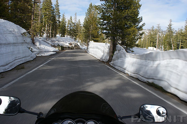
Highway 4 at Alpine Lake during Spring 2023, during which the Sierra Nevada had the most snow in 70 years.

The Bear Valley ski resort is still in operation after changing ownership recently and surviving the worst drought in California history, which ended in massive snowfalls of the 2015-16 winter. Then in 2023, the most snow in 70 years fell in the Sierra Range pictured above.
Bear Valley Resort spans 1680 acres and 75 different runs. The trail system around the resort consists of 3000 acres of mountain terrain accessible by the public for cross country skiing & snowshoeing. As you ride past Mt Reba Rd to the ski resort, there’s the small national forest campground of Silverfork, and then the fun begins.

Alpine Lake with Inspiration Point in the background
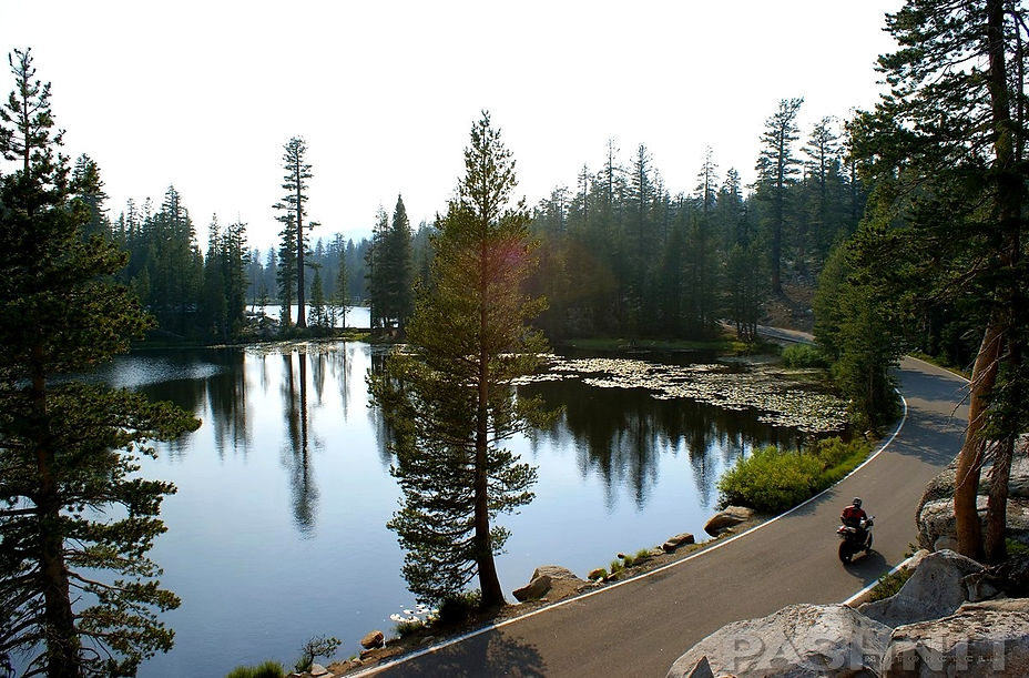
Alpine Lake
Highway 4 narrows to a no-center-lane-single-lane paved road. Yes, two cars fit, but that no center line generally has all the traffic headed right up the middle of the road. Which creates an added element for the motorcyclist. Don’t cut corners and always enter all left-hand blind corners on the outside of your lane. Using a Delayed-Late-Apex technique is more important here than anywhere. As soon as you let your guard down or get sloppy in your line of entry, there will be a truck coming right at you.
Portions of the ride are very steep with a 24% grade in several locations with two different sets of multiple hairpins on the eastern side of the range. Large trucks or large RVs with trailers are strongly discouraged. Signs warn against any vehicles longer than 25 feet. Last ride through here, passed a Greyhound-sized RV driving down the steepest portion at about 15 mph in low gear.
There are three lakes along this stretch that are right beside the road, Alpine Lake on the west end of the ride is the largest. The picturesque Mosquito Lake is the mid-point and the perfect stopping point. On the far eastern side of the range is the small Kinney Reservoir.
Alpine Lake is the first thing you come to a few yards after entering the Stanislaus State Forest. There’s a small general store & restaurant here overlooking this mountain lake. Lake Alpine Lodge dates to 1927, but the present-day lodge was built after that building collapsed from heavy snowfalls in 1932. All that remained was the stone chimney, and the current lodge was rebuilt around the chimney. Alpine Lake was created in 1892 when the creek was dammed and the valley allowed to fill providing a steady supply of water to mining operations in Angels Camp.
Several cabins around the lake date to 1928 and there is a walking path that circles the lake, 2-miles of it are paved. That also means some degree of congestion with campers, people out walking, and bicycles crossing the highway to reach the general store. There are no sidewalks or crosswalks, so a judicious speed is required around Lake Alpine. A ridge line overlooks the south side of the lake and there are hiking trails Alpine Lake up to Inspiration Point atop the ridge.

Kinney Reservoir
_JPG.jpg)
Riding at the 8000 ft level in mid-June. Snow levels vary greatly year to year.
.
Highway 4 has the opposite setup to its counterpart to the south, Highway 108. While 108 is straight up and straight down, Highway 4 is a gradual climb then plateaus for 23 miles across the Sierra Nevada Range with the one-lane section. The plateau also gives it two summits and a depression in the middle, holding Pacific Valley & Hermit Valley. The benefit to the rider is two accents, two steep descents, and two summits. Twice the fun.
East of Alpine Lake, the elevation begins to climb and squiggle back and forth as a hard left appears, and the ride flows uphill into a forest of pines. There are several sleeper corners here, but this ride is pure unbridled joy. If you could bottle joy and sell it, you would come here to collect it. Popping out of the forest into a break in the trees presents broad views of the nearby mountain ridge lines.

Sight lines are often extended and pronounced, yet the one-lane section still includes a proclivity of blind corners. With the road being so narrow, prudence dictates always enter these lefts on the outside line to allow a margin of error.

Walking on Mosquito Lake in mid-June, Winters vary greatly at this elevation
Same spot as above, same day, same month, different year at Mosquito Lake.
Without fail, you’ll enter a blind left, and a camper will be coming right at you. Every vehicle is headed right up the middle of the road due to the lack of a center line. Sand on the road is a constant issue as vehicles either cut the corners, or dirt roads that lead off into the forest bleed sand onto the main road as vehicles pull back onto the highway.
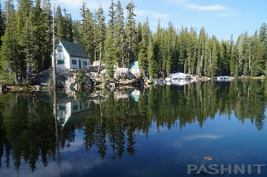
Mosquito Lake
Seven miles to the east of Alpine Lake, you’ll arrive at one of the most picturesque lakes in the Sierra. Mosquito Lake at 8,040’ is tiny, shallow, fit only for kayaks and canoes, and drains into two watersheds- the western side into the North Fork Stanislaus River, the eastern into Pacific Creek and then into the North Fork Mokelumne River from its position at the very crest of the Sierra.

Several 1920s-era cabins at Mosquito Lake create a picturesque scene

There is a small first-come-first-serve primitive national forest campground here with no services. On the west side of the lake are hiking trails to the south to reach Heiser Lake and Bull Run Lake at the 8400’ level.
Highway 4 was cut right at the edge of this small body of water. In the middle of Mosquito Lake is a small summer cabin that’s been photographed by every traveler that comes this way. The cabins date to the 1920s when several Angels Camp residents traveled here and built summer cabins. The pond was dammed, and the water level raised to resemble a small lake. Mosquito Lake is the mid-point of this ride, and often one of the best stopping points for a quick break.
There is a pull-out in the middle of the lake that is a favorite stopping point for our motorcycle tours over the last 20 years. There’s an unmarked dirt road at the pullout along the lake that extends a mere hundred yards. It is worth walking up that pops out on the crest of the Sierra Nevada and looks down on the Pacific Valley below on the eastern side of the Sierra Range. At the east end of this tiny lake is the Pacific Grade Summit at 8050’.


Same exact spot as above photo. Snow levels vary greatly year to year.
This is not Ebbetts Pass. That is off to the east, and we have the one lane section to take us there. Beyond Mosquito Lake, Hwy 4 drops off the mountain top with a mad dash into the Pacific Valley through four tight & steep switchbacks at a 24% grade. Take the outside line on the switchbacks. We’ve watched riders take the inside line headed up, enter in the wrong gear and simply fall over. Not crash, simply fall over in these tight hairpins. Follow the proper ride techniques and stay safe while you negotiate these fun hairpins.

The ride drops a rapid 1000 feet through the switchbacks, past a small forest service cabin, over the North Fork Mokelumne River to Hermit Valley at the 7080-foot level into a flat meadow.
At the base of this drop is Pacific Valley Rd, which flows up Pacific Valley along Pacific Creek to Pacific Valley Campground into Marshall Canyon. The road dead ends 2 miles in, converting to a Pack Trail for hiking to the top of the range at Bull Run Peak and over to the aforementioned Spicer Meadows Reservoir.
Hermit Valley
Hermit Valley holds their own free music festival each year in early September, which also means an increase on traffic on the first of second weekend of September. Look up the event if you’d like to attend. No raging rivers here, we’re so high in elevation, the water flows by in a small creek beside the road.


Hermit Valley Campground is where the original mountain pass turned due north all the way to Highway 88.
In 1856, a road was completed following the present sign Route 4 from Murphys to this point. And thence northward via Faith and Charity Valleys to Hope Valley where it joined the Carson Pass Road. This connection was used by Emigrants in 1856 and 1857. Remnants of the old route are still visible to the north of this sign and along state Route 4 to the west.
The original Highway 4 ended here at Hermit Valley, and it wasn’t until silver was discovered in 1861 at Silver Mountain a few miles east of Ebbetts Pass that interest in completing the road to the eastern side of the Sierra grew.
Highway 4 was quickly extended out of Hermit Valley to reach the precious metal while Silver Mountain City was erected overnight with 1000 people living there by 1863.
Ebbetts Pass
Ebbetts Pass summit sits at 8730’ and is actually a flat spot in the ride verses its southerly neighbor Highway 108 which is atop the steep crest of the range.
Named after Major John Ebbett and pointed out in the 1853 to surveyor G.H. Goodard who referred to it as a “Route of great promise – probably the best one for the Transcontinental Railway.” No emigrant train used this route, but a stage road was completed here in 1864 to serve the mining region of Silver City.

Directly behind the sign at Ebbetts Summit is a dirt forest service road 8N04 that leads up to a parking lot 1/4 mile away at the base of Ebbetts Peak. It probably should be a high clearance dirt road, but I rode up to the parking area on the Hayabusa just to check it out with no issues. From here, you can park right at the base of the peak, hike up a gully and walk up to the nearby peak. Likely it’s one of the closest mountaintops you can actually ride to and then continue a short walk to the summit. Another day when I'm not in full leathers.

Pacific Crest Trail
A few feet east of the summit sign, the Pacific Crest Trail flows across Highway 4. The Pacific Crest Trail is a walking and equestrian path closely aligned with the highest portions of the Cascade and Sierra Nevada mountain ranges beginning near the Mexican border in Southern California and extending 2650 miles to the Canadian border. The Pacific Crest Trail was first proposed around 1932 but wasn’t completed until 1993.
As Highway 4 drops off the second summit, it opens up with broad views of the valley below. To reach the silver and continue building Highway 4, the ride drops rapidly again through several tight switchbacks signed at 15 mph into Noble Canyon. Halfway down the drop (or climb) is Toiyabe National Forest Campground, so keep an eye out for campers entering and exiting the entrance. Hairpins can be dirty, so it's always good practice to expect gravel in the corners and always take the wide line. There are no guard rails anywhere, and it's a long way down.
You may have noticed riding over several cattle grates along this ride. Word of advice is be in the habit of hitting the grates head on, or always perpendicular verses at an angle leaned over. Wet metal and motorcycle tires don’t go together. These cattle grates are a reminder that much of the Sierra Nevada is open range.


There are several cattle pens along the ride where the cattle are seasonably rounded up. Some may have a cow bell around their necks, most do not. It is not uncommon to come barreling around a corner and find a cow standing in the middle of the road.
Kinney Reservoir at 8350’ is the third and final lake along this route, dammed in 1926, it was designed to provide a steady flow of water for irrigation in the Carson Valley below. There is almost always someone fishing here as it’s an easy-to-reach spot for catching brook, rainbow and cutthroat trout.
One-mile northeast of Kinney Reservoir is Trout Rock seen by the eastbound traveler. For the westbound rider, someone has sprayed graffiti on the rock with the words, Big Fish Corner. Not quite as interesting as a Bra Tree, but a rock shaped like a fish might interest somebody.
Silver Mountain City
Noble Canyon holds the ghost town of Silver Mountain City. By 1864, Silver Mountain City, el 6250’, was designated the county seat of Alpine County. As most boomtowns went, the silver was played out by 1868. Townspeople carried off entire buildings, brick by brick along with every board and took the town elsewhere, moving on to the next silver boom at Monitor and Bodie. All that remains are the stone walls of the jail. Even the jail cells were removed and taken to Markleeville. Each year in the summer or early fall, the Alpine County Historical Society marks out the buildings that once occupied Silver Mountain City, and you can actually 'tour' the town.


Fall colors at Scossa's Cow Camp
Settled by Scandinavian miners in 1858- then called Kongsberg. Renamed Silver Mountain in 1863 and made county seat of Alpine County Aug 11th, 1864. During the sixties, the town supported a post-office, two newspapers, Express office, telegraph office, and several hotels. Population was at its peak in 1864. County seat moved to Markleeville Nov 1st, 1875.
Beyond the old town site, the no-center-line-one- lane pavement sadly ends, and Highway 4 continues in a relatively straight line along Silver Creek into Ixl Canyon through a smooth S curve with white aspen trees lining the side of the road. A grassy meadow here holds cattle, and sometimes horses grazing.
Scossa's Cow Camp
The curious site of the Scossa's Cow Camp is here in this stand of aspen trees, this is a private property settled in the 1870s by four brothers at the 6200 ft elevation.
The simple board and batten buildings that resemble a small barn at the Scossa Brothers Cow Camp were erected by the Isabella Mining Company of London, but an old silver camper that’s been here for decades sitting among the white aspen trees is the true takeaway.
In fall, around September before the snow flies, the leaves turn and this narrow valley with the green meadows comes alive with color. Then to add to the picturesque scene, a short distance downhill from the cow camp is the Chalmers’s Mansion and pioneer cemetery.
Dating to 1862, this white house had a smelter beside it although now all that remains of the smelter is the chimney. Ore was pulled from nearby mines, and then smelted, or burned in fires, to extract the ore through a process of heating and melting. Heating the ore drives off the other elements and leaves the base metal behind. Today, this a privately owned land.
As the elevation drops below 6000 feet, it’s a dead run alongside Silver Creek past the old mining town site of Centerville Flat. This once busy western boomtown is now a campground. Wolf Creek Rd is found here at the campground and flows for 7 miles past the old Dixon Mine up this canyon for the dual sport riders and UTVs.
Highway 4 finishes up here with a 3-mile run along the river to the Highway 89 Monitor Pass junction.


Chalmers’s Mansion & smelter
This stretch of Highway 4 is a favorite with anglers and you’ll see vehicles (possibly even a van) parked down by the river which is a rushing torrent in spring as all the surrounding canyons, rivers, and streams all flow into this stretch of water.
Highway 4 ends at this junction and the road designation changes to Highway 89 into Markleeville. If you need gas, Markleeville is your only option five miles away from the junction.
Northbound: Continuing through Markleeville leads back to Highway 88 Carson Pass and back to South Lake Tahoe or dropping into Nevada. Highway 88 Carson Pass is the next mountain pass to the north and one of the few mountain passes kept open year-round. Highway 4 will be closed in winter and usually opens up by Memorial Day in late May. A few years ago, heavy winter snows kept it closed into late-June.
Southbound or Eastward: Continue with Highway 89 Monitor Pass. This ride is said to be the best motorcycle road in the state of California and produces stunning photos. There is also a fire lookout overlooking Monitor Pass. The road to the summit is dirt, and not marked, but worth the ride to the summit for terrific views. I rode past it for years before finally getting curious enough to ride up to the summit. Monitor Pass is short, quick and stunningly scenic, dropping to Highway 395 to Coleville and Walker. One of our favorite resting places in the state with Pashnit Motorcycle Tours is the West Walker Motel in Walker. Topaz Lake is a casino on the Nevada border and lies to the north of the 89/395 junction. There is gas in Topaz at the casino or in Walker at a single 1980s era pump (no 24-hr card lock in Walker).
Closing Thoughts
I can’t tell you what the best motorcycle road in California is. That’s your problem to solve, despite whatever mathematical formula we might devise. I can tell you though that Highway 4 is a very enjoyable ride, intensely scenic, and highly unusual. Highway 108 and Highway 4 make the perfect day ride loop of about 200 miles, this is not a long distance to connect them together and offers plenty of time for stopping at the local sights.
Other Thoughts on Highway 4:
I think one of the nicest rides around is Highway 4 out of Angels Camp, CA. Come south on Highway 49 (the Gold Country Hwy, and an interesting ride in itself) out of Placerville to Angels Camp (or come up 49 from the South). Lots of great places, curves and scenery along this "get to" route. Head East on Highway 4 out of Angels Camp and proceed through some nice scrub oak foothill country. Traffic gets progressively lighter until about 20 miles out of Angels Camp when you aren’t going to see many tourists. At about 25 miles out, one will find Calaveras Big Trees State Park with its magnificent trees, trails and neat camp sites. From then on, one will experience a well-paved, banked, curved, up and down road all the way to Highway 89, about 30 miles further. The grandeur of this route will blow one's mind: deep valleys, magnificent redwoods/cedars/pines, forest everywhere ... and minimal gawkers, although the view is worth gawking at. -Jerry
Highway 4 - Photo Gallery


MORE INFO: Highway 4
RIDE IT on a PASHNIT TOUR
(Angels Camp to Highway 89 Junction - LENGTH
Well-maintained - PAVEMENT
Steep hairpins, single lane, numerous - CURVES
Numerous - LODGING
8750 ft- PEAK ELEVATION
LISTED CONNECTING SIDEROADS:
O'Bryens Ferry Rd
Rock Creek Rd
Pool Station Rd
Highway 49
Parrots Ferry Rd
Six Mile Rd
Sheep Ranch Rd
Fullen Rd
Avery Sheep Ranch Rd
Dunbar Rd to Sierra Nevada Logging Museum
Calaveras Big Trees SHP
Spicer Meadows Rd
Pacific Valley Rd
RELATED INFO:
Scenic Byway 4
Calaveras Big Trees
Ironstone Vineyard Heritage Museum
Historic Highway 49


