Central Coast Range, California

San Luis Obispo County, CA
9 Miles - Length
San Luis Obispo- COUNTY
Atascadero - GAS

Highway 229 - Rossi's
Quick Ride: If Valentino Rossi had a driveway, this would be it. One of the most unusual motorcycle roads in the state. Narrow, short, twisty, fast, invigorating, simply amazing. Ride it, turn around, and ride it back the other way.
Rossi's Driveway
Several decades ago, I worked for a company that sent me across the state, on business. It was my first real job after college, I had health insurance and an expense report. My employer at the time had a contractual relationship with 911 Call Centers across the state, to which my job was to travel to a great majority of them and train the employees on equipment my employer had supplied to them. I could fly. Or drive. Or, I could ride my ’93 Kawasaki ZX-11D. I chose the latter. The goal at the time was not to hop on the freeway and zip across the state, but rather to leave a day early and seek out the twistiest route A to B. And it was on company time. No wife, no kids, no mortgage. I was being paid to ride, and I could expense my mileage. Tires I had to put those on myself. I was going through a set every couple months.

On this particular trip, I had to ride from NorCal to SoCal, the length of the state on the ocean side. It made sense to figure out a route through the Coast Range as I was being sent to Ventura. Now kids, this was before GPS, Google Maps & Satellite maps didn’t exist yet, there were only antique paper maps, and a bit of guess work. The most detailed planning tools were AAA Sectional Maps and a coil bound book called a Thomas Guide you could buy at a book store.
Those were my only planning tools I could obtain at that time. This road connects to that, this connects over here, and that one looks twisty. That was the extent & depth of planning back in the Olden Days. I had no idea where I was going, no idea what was in store, and no idea what the journey would be like. No idea what the terrain would entail. All things we can look up in seconds in present day.
I only knew I have to be here at this address at 9 AM on a Thursday. No one cared how I got there. And that job led to more discoveries and more joyous solo road miles than one could imagine while we worked on that project with the 911 Call Centers for many months. I discovered many fun roads during those numerous trips to remote corners of the state. Destinations ranged from Indio to Susanville to Eureka to Ventura, all four corners of the state. I have to tell someone about this road. It became a mantra. And those journeys around the state ‘for work’ set the framework to share those travels on something brand new called the internet, and subsequently, for a tour business to further share those travels in person. No one plans these things, rather they all happen in a series of unplanned steps.
The logical route in staring at the map planning a north to south route through the Coast Range was into Hollister, down Highway 25, over Highway 198 and over to Cholame as I had read about a James Dean Memorial at Cholame and that sounded interesting. From there, I’d make my way over to Highway 58 and then through Taft to Pine Mountain Summit over Highway 33 to make it to Ventura for the training I supposed to conduct.

The route took me through Creston. There were three routes south out of Creston. This small ranching town east of Atascadero was anchored by a single restaurant & market. The town is tiny, listed as 39 households. The region was rolling treeless hills, and there were horses everywhere. Alex Trebek, as in game shows, owned the Cardiff Stud Farm nearby. Creston was also the final resting place of Scientology founder L. Ron Hubbard who owned a ranch in the Creston area. Anchored by the Creston Market for groceries, and next door, the Loading Chute Restaurant and Barn providing good eats. There were dusty pickups parked out front. What more could you want in a small town?

I missed my planned turn-off, twice. La Panza Rd and O’Donovan Rd are short-cuts out to Highway 58, I would later ride them and they were best described as ‘okay’. I missed both of them blithely continuing south assuming, I should hit Highway 58 eventually as I knew it bisected the region. This region of San Luis Obispo has seen fields of grape vines increase exponentially where there were once only cows and a few alfalfa fields.

This route took me onto a short 5-mile stretch of road labelled as Webster Rd / Highway 229, which was not part of my original plan, to connect with Highway 58. It was simply a quick connector to get from Highway 41 to Highway 58.
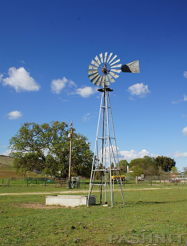
The pavement led due south out of Creston, past the dirt ranch road Rocky Canyon Rd (connects back to Atascadero), and an old timey windmill with Aermotor printed on the wind vane, the kind from the cowboy movies I watched as a kid. Aermotor Windmills were first produced in 1888 and are still being manufactured today. The spinning of the wind vanes spins the hub assembly and drives a geared mechanism that converts rotary motion to an up-and-down motion. That up-and-down motion drives a long sucker rod, also known as a pump rod, up and down inside of a pipe in the well, pulling water to the surface into the adjacent storage tank next to the tower.
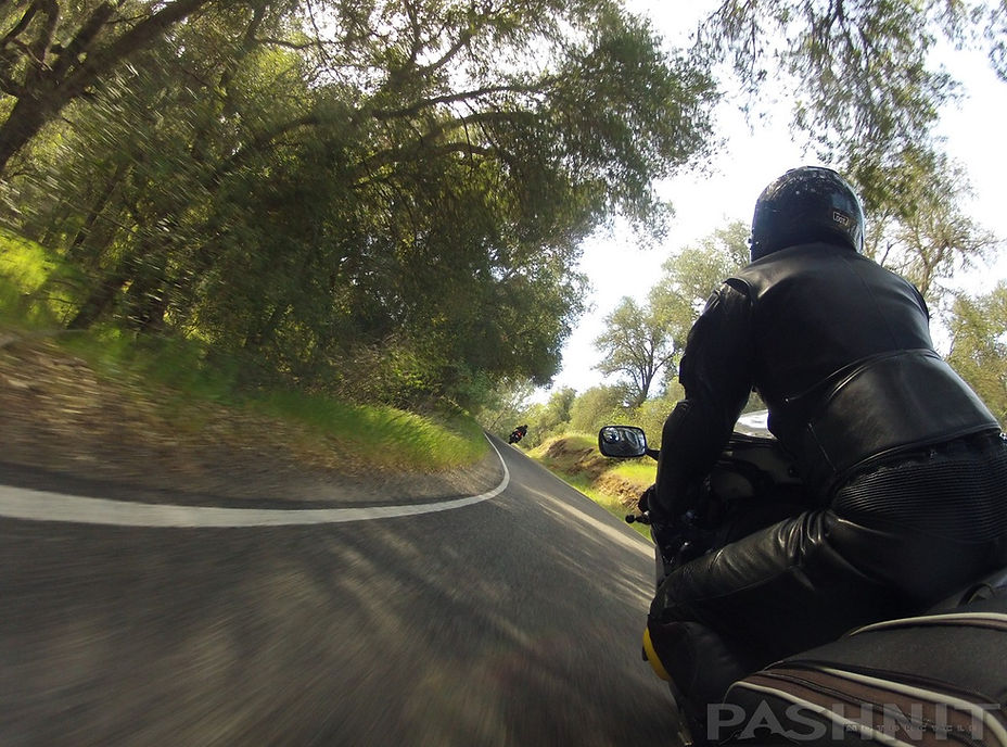
The center line ended, the road narrowed to a single lane and flowed over a small rise, then into a relaxed S-curve, then another, then another. What just happened? Now, in a normal world, this would be a bumpy goat trail, with long-forgotten road surface, off of any road maintenance crew’s To-Do List.

Hello, have we met? What do we have here?
Surprise and excitement coalesced into pure glee. The road was smooth, no center line and demarcated by only painted white lines at the sides. There was zero traffic, none. No other cars (at least for this journey), and I was alone, swallowed whole by a sense of marvel, trying to comprehend my discovery. What is this, why is this here? The road straightening crew that’s working on our beloved Highway 36 hasn’t discovered this one. The road resembled more of a driveway leading up to a home high on a hill. Oaks hung low over the road which created a series of light-dark sequences, prompting me to flip up my tinted shield.
This road invites speed, calling out in a siren song. Meadows and pastures line the road. Driveways for ranches line the northern half. People live on this road. Not many, but there are several.
Sand and gravel on the road were immediately apparent and you’ll need to be extra vigilant for the duration. The road surface is so narrow, vehicles are cutting the corners and throwing a mist up onto the road surface. This is a constant issue and will never change except for the changing of the seasons. Often, the wheel tracks are the safest line, but you may see a sharp left completely covered in sand from runoff.
Negotiating these sand patches is done with a technique we call the Float Rule. Setup is all done before the turn begins. Enter the sandy portion of the turn, then no input. There is no braking, no throttle, no leaning allowed in the sandy portion. Float across back onto clean pavement and continue the ride. Spring rains cleanse the road but this is a dry area of California so the rainy season is short and non-existent after April.

The northern half includes several quick straights that may seem a good place to wick it up, but first time through, take it easy there, Speed Racer. While there is see-through, Highway 229 has many blind corners, and… you’ll need to remind yourself, it’s not a one way. Pop around a corner and a car is coming right at you. Enter a left hander and you should be set up on the outside practicing your Delayed Late Apex techniques. Practice entering the left-hand corners on the far right of your lane, when you see the lane is clear, cut across the lane and set up for the next corner. You’ll get comfortable with the rhythmic nature of this road, but when you least expect it, a car will be coming right at you out of a blind corner.
Highway 229 climbs up to the crest of a low rise, at the top are large dual water tanks, presumably the water supply for the town, and the second half begins. While the elevation change is steady and minor, the road enters a narrow canyon and flows down the hillside along a dry creek bed.
Off-chamber turns, where the pavement is slanted left in a right-hander, banked turns, S-curves, gravity bowls, there’s one of everything. No hairpins, but tight corners yes.
And that tight left hander is as mentioned, all sand on the inside so expect it.
We have another rule on rides that applies to this road, “There are no surprises in riding. If you’re surprised by anything on this ride, you’re going too fast for your ability.” Expect the opposing traffic, expect the sand, expect the car in the driveway doesn’t see you, expect bicyclists on blind turns. Anticipate. There are several pop ups, enough that the right bike can get airborne. Watch Joe’s video above of Drew on the DR650. Right bike, right conditions, super fun.
On my first ride through Highway 229, I was beside myself, giddy with glee. Amused and amazed, basking in the sensation of the left right left side to side, trail braking, biting the rear, accelerating out of the corners into the next.
I reached the end of Highway 229 at Hwy 58 and promptly turned around. It was that fun. Riding it the opposite direction northbound, it was a brand-new road and twice as fun as I now knew what to expect. Rossi’s Driveway is like that. Two decades later after that first ride, Pashnit Tour riders would do the same. They would reach the end, then simply turn around and ride it back the other way. It’s five miles. You have the time.
Nothing is that important that you can’t add an extra 10 miles to your journey. Highway 58 came next, through Taft, and on to Highway 33 into Ojai. I made it to my training, and then headed back north to explore even more roads. But, it was Rossi’s Driveway that stuck in my mind. At the time, I had never seen a road like that, and the experience stayed with me for many years. Fast forward twenty years and we ride Rossi’s every time I bring a tour group to the San Luis Obispo area around Atascadero & Paso Robles.
Highway 229 is a destination, a Disneyland for riders, and your first-time reaction will likely be much the same as mine was: If Valentino Rossi had a driveway, this would be it.

Where to next?
On my first trip through here, I had no idea what other roads were nearby. I hopped on Highway 58 and headed out to Taft passing by Bitterwater Rd. But the real diamond in the rough that’s nearby is the Pozo Loop and the Las Pilitas – Huer Huero loop.
At Highway 58, head west 3.5 miles to Pozo Road. Another 3.5 miles southeast via Pozo Rd to Las Pilitas Rd. Super fun high jinx come next on a zippy ride on over to Parkhill Rd. North on Parkhill 100 yards to Huer Huero Rd and you’ll emerge only 3 miles east from where you started at the south end of Highway 229. Got the time, you must ride the Las Pilitas Loop.
You can read more about the Las Pilitas Loop, Pozo Loop, and Black Mountain Road up the FAA Radar Tower on the Highway 58 Page.
Highway 229 Rossi's Driveway - Photo Gallery


MORE INFO: Highway 229
RIDE IT on a PASHNIT TOUR
9 Miles - LENGTH
Very good, strangely smooth, single lane - PAVEMENT
Blind, pop-up, gravity bowls, off-chamber, inside sand - CURVES
Atascadero / NO gas in Creston, Cholame, or Shandon - GAS
Atascadero / Paso Robles / San Luis Obispo - LODGING
GPS LOCATION
35.5187°N 120.5238°W - Creston
LISTED CONNECTING SIDEROADS:
O’Donovan Rd connects to Highway 58
Rocky Canyon Rd ( dirt )

Topo Maps
The Perfect Combination: Ride Las Pilitas to Huer Huero to Highway 229
