Northern California
Santa Barbara County Motorcycle Rides
Southern California
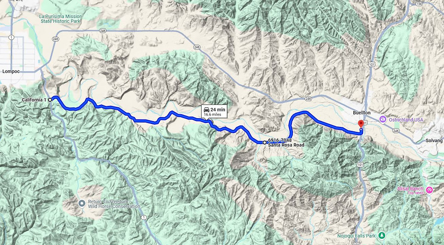
Santa Rosa Rd
17 miles - LENGTH
Narrow paved ranch road- PAVEMENT
Creek bed road, gentle- CURVES
Lompoc to Buellton - CONNECTS
Santa Maria, Solvang, Buellton - GAS

Quick Ride: Relaxed farm road connecting Hwy 1 to Hwy 101

Lompoc to Buellton, CA
It was the smile on his face that told the story.
Slowly, he bicycled on by, gave a slight wave and continued pedaling down the road. It was at that moment I knew I'd come to the right place.
Motorcyclists come for different reasons. Some want endless curves, others open road and smooth pavement. But in the end, none of those things mattered, I just wanted to ride. Didn't matter where. No particular hurry, no particular place to be. I was enjoying being out there, and once I saw that smile, it was then I knew I'd found the place I was looking for.

I became interested in this particular ride while pouring over a map of Santa Barbara County and noticing this relatively straight line that gave a sense of being deserted. It was surrounded by main highways on four sides- a sure indicator that everyone you know avoids the road. This isn't the type of ride that will transport you as quickly as possible to where you need to be. Wrong reason to come out here.
I approached Santa Rosa Rd after exploring Jalama Beach Rd on a daybreak ride out to the ocean.
Well-marked along Highway 1 just outside of Lompoc, I turned onto Santa Rosa Rd and made off eastbound. Pavement as you can see from the photos is okay at best. I've definitely seen worse and later in my riding day on Figueroa Mountain Rd would see potholes I could park the bike inside of, so this was no time for whining.
The ride is bordered by Hwy 246 to the north, Hwy 1 to the southwest and Hwy 101 freeway to the east. It quite simply is the only major through road in that entire block of land.


Besides being surrounded by main highways, Santa Rosa Rd lazily weaves its way through a valley between the Santa Rosa Hills to the south, and the Santa Rita Hills to the north while following the general contours of the Santa Ynez River.
Sweeny Rd is a paved road you can visibly see on the north side of the Santa Ynez Valley that originates in Lompoc along Hwy 246, however it only extends 5.7 miles into the valley before ending in a field as a dirt farm road.
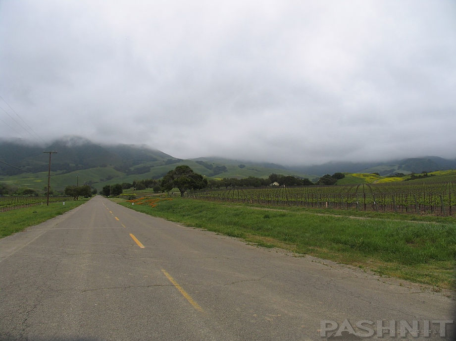
Santa Rosa Rd on the western end starts off level with the fields. Straight and flat at first, the pavement hugs the edge of the range on the southern side of the valley slowly meandering along the base of the hillside.
Fields of produce stretched off across the valley and arrow straight rows formed a patchwork of possibilities with crops the valley produces.
There are two low up-an-overs where the road climbs up the side of the range. Not very high elevation-wise, but nevertheless a panoramic view of the Santa Ynez Valley presents itself. If you look closely, you can see Sweeny Rd running parallel on the far north side of the valley.


The fruit basket of produce ranged from lettuce and cabbage, to an orchard of nut trees to eventually vineyards that stretched up the sides of the rolling hills. Can't say there's much in the way of amusement parks, mini-malls or much of anything along this ride though.
After the first crest that provided the panoramic view, Santa Rosa Rd drops back down to the valley level. The endless rows of cabbage came right up to the edge of the pavement as farms eek out every square foot of farmland to grow produce.
A straight appears and the ride shortcuts across the field seeming to cheat me of my meandering hillside ride. At the orchard, I stopped as I often do on rides, this time to admire the perfectly straight rows of mature nut trees.
It was spring and all the world was a brilliant emerald green radiating color with a robust vigor. Beneath the trees in the orchard, the grass had been mowed creating a sheltered manicured lawn from the wind and even sky above. Clouds of coastal fog hung low at the level of the mountain tops reminding me of how close to the Pacific Ocean I was. Santa Rosa Rd is quite literally just over the range from the coast providing a sure and steady supply of moisture.
Plants, weeds, and grass grew right to the edge of the road, and at times out onto the road itself attempting to close in on the pavement. Each time the realization comes to bear that I've come to the right place, it's sure to be found on a quiet deserted road.

The eastern portion is more of the same. The road ahead attempts to lift itself off the valley floor for a few more feet in elevation climbing up the adjacent hillside gently arcing around the coastal range. Still following the smooth arcing of the nearby Santa Ynez river, the river bends, the road bends. A meandering ride at best, Santa Rosa Rd contains few surprise corners. Pavement quality never improves, or gets any worse for that matter. A center line magically appears at the Sanford Winery.
Descending, or rather coasting down the eastern climb eases the road back down to the valley floor. To the north of Santa Rosa Rd on the other side of the river is what looks like a horse racing track at the end of Mail Rd, but viewing it from a distance across the Santa Ynez Valley, it looked more like someone's backyard. Handy thing to have if you have horses. The eastern half finishes up with another long straight across the vineyards, lazily skirting around the coastal mountain top (I kept wishing I had a dual sport and could ride to the top) and then past several more small farms into Buellton.
The 101 freeway shows up and you have plenty of options. There's a name change here to Avenue of the Flags Rd which is worth noting if you are negotiating the wilds of Buellton. Avenue of the Flags Rd (originally Highway 101 until the 1960's) parallels the freeway if you are approaching from the east and should find yourself on it wondering how to get to your road- it turns into Santa Rosa Rd on the south end.
If you're riding this westbound headed for Lompoc or Jalama Beach Rd via the Highway 101 freeway- exit on the south side of town (just three exits for Buellton- middle is Highway 246), and Santa Rosa Rd starts up immediately.
Buellton is a small town that sits atop the junction of Highway 246 & Highway 101. The nearby touristy Solvang is a short ride away up the heavily trafficked Highway 246. To avoid this slow drudge to Solvang, I headed off to the next logical deserted joy ride - Alisal Canyon Rd.
Nearby Motorcycle Roads - Where to next?!!
Northbound: Vandenburg AFB encompasses 400 square miles to the immediate northwest, but for northbound options towards Santa Maria - try Drum Canyon, Harris Grade Rd (busy) or my favorite, the (from Solvang) Ballard Canyon - Foxen Canyon Rd - Tepusquet Rd combination to Highway 166.
Southbound: South of Santa Rosa Rd is Highway 1 & the Pacific Ocean. Access to the ocean is limited in most of the immediate areas. Jalama Beach Rd provides the only paved access. Nearby Refugio Rd from Solvang does go up and over the range, but is dirt in the mid-section.
Eastbound: If you ride this eastbound, you'll come headlong into the Highway 101 freeway. A turn south on Highway 101, a short distance away is Alisal Rd which will connect you to Solvang if you want to avoid the busy tourist laden Highway 246. Then connect with Foxen Canyon or Figueroa Mountain Road.
Westbound: You have to ride Jalama Beach Rd out to the ocean. You just have to.
Santa Rosa Rd, Santa Barbara County - Photo Gallery


MORE INFO: Santa Rosa Road
RIDE IT on a PASHNIT TOUR
17 Miles - LENGTH
Deserted farm road, smooth, backroad - PAVEMENT
Gentle, smooth, - CURVES
Lompoc Hwy 1 to Hwy 101 Buellton - CONNECTS
Lompoc, Buellton, Solvang - GAS
t- PEAK ELEVATION
s- MOUNTAIN PASS
40°23'45.4"N 123°26'07.0"W - GPS LOCATION
None - LISTED SIDEROADS
Maps