San Benito County Rides
Central California
Panoche Rd
RIDE IT on a PASHNIT TOUR
San Benito - COUNTY
48 Miles - LENGTH
Poor in most parts, narrow, - PAVEMENT
Climbs over low range, Gentle - CURVES
Hwy 25 to Interstate 5 - CONNECTS
Tres Pinos, Hollister, Interstate 5, - GAS

Quick Ride: Remote stretch of Coast Range few have ridden, dry & hot in summers, brilliant green during springtime, cattle range land in San Benito County, good east-west connector into Central Valley

Ever been on Panoche Road, he asked?
Ah no, I said.
You're going to like this one, come on!
Fuel topped off, he threw a leg over the Honda RC51 and we pulled out of Tres Pinos. With a range of just over 100 miles on the RC51, gas stops had to be planned carefully. Southward on the much-vaunted Highway 25 and a few miles later, we hit the intersection with Panoche Rd labeled on the map as Paicines. No town, but there's a general store, a winery, and a small body of water here.

The Paicines General Store 13 miles south of Hollister is the only real landmark and there's no gas at the corner. Across the highway on the west side is the Paicines Reservoir. This portion of Highway 25 runs right over the top of the San Andreas fault and much of the surrounding land features are a result of the shifting landscape under our feet.
One part is headed north, one part is headed south. The small Paicines Reservoir, built in 1913, is a favorite of bird watchers after some bald eagles were spotted nesting there. Also known as a Sag Pond, the land is sinking because it lies over the two faults strands.
Adjacent to the Paicines General Store is the Blossom Hill Winery, bought out in 2017 and re-named Alba Coast Winery. The name Alba means ‘dawn’ or ‘sunrise’ in Italian.

With capacity for 4 million cases a year, you’ll see huge tanks in a broad group alongside the road that make that number believable. On the north side of the road are the large buildings of Diageo Chateau & Estate Wines.
A long straight appears and the ride is on. We blow by a pickup truck with a hay bale and a dog on the flatbed behind the cab. It's covered in dust and the driver seems in no hurry to get where he's headed. I know then we've come to the right place.
Panoche Rd starts off on a southeasterly trek alongside Tres Pines Creek which is a sandy wash during the dry season. My map labels a runway alongside the road just west of Browns Valley Rd but all I saw was a bunch of dirt. Possibly you could land a plane there. Maybe. Maybe years ago. There are a series of homesteads & ranches along the road, but traffic was non-existent if any.
Panoche Road is also known at Highway J1, or a series of connected roads that lie within the “J” zone of California.
Panoche Road lies within the corridor of an unbuilt Route 180 segment and there are no plans to extend Hwy 180 which is better known as the ride that heads up into the Sierra to Sequoia & Kings Canyon National Parks due west.

Browns Valley Rd is worth mentioning for the dual sport riders as it's a dirt ranch road and when connected with Santa Anita Rd (paved), aka McCreery Ranch Road, will circle back to Hollister. Landscapes along the road are grassy rolling hills used for ranch land, brilliant green in spring, and burnt golden brown the rest of the year. Use of county level maps or a GPS is recommended if you head off the main highways into the surrounding hills.
As we rode past Browns Valley Rd, the pavement was deceptively inviting, broad and smooth, with the road slowly bending deeper into this valley which begins to narrow about 5 miles in. Corners are broad sweeping affairs of... well, let’s put it this way, one of these corners lasts for 2 miles.

Like many good things, this flat stretch of smooth corners doesn't last, nor does the quality. Now the real fun begins, I could feel it.
Pavement deteriorates as Panoche Rd begins to climb the low range gaining elevation while weaving back and forth.
Twelve miles in after wondrous sweeping corners, we hit a nifty stretch of fresh pavement due to a massive slide which took the road out in a few years back. That didn't last. While the road remains the usual country lane, the occasional rippled heaves and potholes began to appear and a rough ride it became. Sometimes smooth, then not.
What you can't see in the photo at left is the sense of height on these heaves in the road.
Several heaves were so high, automobiles had bottomed out and scrapped the tops off. It was amazing and reminded me of frost heaves in Alaska where the roads would simply buckle. Road conditions will constantly change over the years, and likely by the time you ride this, the one picture above has long been fixed. However, it was painfully obvious this was an on-going occurrence along this road.

The highway department seems to have the situation well in hand, or so they think. Every time they fill a pothole in the road, it creates another bump.
Do this a couple hundred times, a couple thousand times, well you get the idea. It was a bumpy ride. Enough to purposely want to steer around the patchwork quilt at times.
Yet the terrain here is one of rolling hills and small ranches, an enjoyable ride thus far.
A brilliant spectacle of injected emerald color thrown out across hillsides topped in trees. Fence posts lined the road and the ranches continued. Traffic was nonexistent.
This is cattle country. Cattle ranching requires 10 acres of property to support a single cow for one year.
And there’s an estimated 33,500 head of cattle in San Benito County. Ranching has been the primary mainstay since the Spanish Rancheros established land grants in the 1700s. The average American is expected to eat 222.2 pounds of red meat and poultry each year and this is where it comes from.
Around the corner, there is more steady climbing up the hillside. The ride went into a left, a right, a left, and I was flush with a sudden flashback of my drill instructor calling cadence barking out orders to ride, tossing the bike back and forth.
A moment of rhythm, with the sweet sound of the bike modulated through corners headed uphill. Steering with horsepower, slow in, fast out, the rear wheel cutting the shape of curve. How much rubber did we leave on this road? All I know is afterwards, I needed a new set of tires.


Like most roads that cut across temporal vegetation zones, and over ranges in California, the entire scene began to change. We were headed further away from the Pacific Ocean into the rain shadow of the Sierra de Salinas and Gabilan Ranges.
The pass would open up a bit, a ranch would appear, and the valley would close back in on itself. Then the road changed altogether- to one lane goat trail. Paved of course, but no more double yellow, same bumpiness as before.
This lasted the remaining distance to the summit. Did we cross into a new county with fewer highway funds? No, still all San Benito County. No rhyme or reason, just goat trail winding its way to the top.
Elevations aren't high, a mere 2319 feet at the summit which we reached after only 20 miles from Highway 25.

No sign denotes the crest, but you'll know when you're headed back down the other side after riding by the Antelope Fire Station. Big Mountain is the tallest nearby peak to the immediate south at 3992 ft. Soon, nothing but grass adorns the hillsides and the tree covered hilltops have faded off to the west or retreated to higher elevations. It's dryer here, even in Springtime when the region gets the majority of its rain for the entire year.
If you ride this in the dead of Summer, do plan ahead as it will be hot. Expect 100-degree temps easily as you come up and over the range and begin to descend into the broad Panoche Valley.
However, the rest of the year can be fantastic. Riding weather in early spring is one of the best kept secrets Californians enjoy. And riding in winter can be one of the best times of the year to go exploring onto a road like this.


Following the narrow goat section in the middle, the fairly decent pavement doesn't last. The road returns to its patchwork quilt motif east of the summit and begins the 5-mile descent into the Panoche Valley. The low coast range begins to flatten out to rolling hills while Panoche Road continues its steady cadence of curves losing some 700 feet, a modest descent of meandering curves past 6 or 7 homesteads (more are up in the hills at Antelope Creek along the road which you can't see), past a small pond, then another private dirt runway. Always handy to have one of those out in these parts.
The Panoche Valley arrives finally as you bend around an aging small orchard of trees at the Spanish Cattle Company. The road does a 90 degree turn here and continues off into the distance via a 4 mile long straight to Little Panoche Rd.

Again, for the dual-sport aficionados, this may interest you: if you continue straight onto the dirt, this is Yturiate Rd which parallels Panoche Rd all the way to Little Panoche Rd. Easy to enjoy this little detour and still meet your riding buddy on the other side, or circle around to the Panoche Inn.
The Panoche Valley is a broad triangle shaped flat valley so isolated, you feel as if you've ridden into a hidden place. Want to get away from it all, this could very well be the moment.
If you're looking for a spiritual experience while astride a motorcycle, this is where you can find it. This occurred to me as I began to traverse this broad valley, at first quite briskly.


But then I let off the throttle and slowed to the point where I was coasting. Then stopped altogether. Cows grazed alongside the road. Unnoticing and uncaring that I was there. A few puffy white clouds, so unusual to see during 6 months of blue skies in sunny, but very dry Central California filled the sky above.
I joined Phil who was waiting at the Panoche Inn on the Honda RC51 and shared the revelation I had. He didn't say anything as a reply. He just smiled knowingly and we walked inside the Panoche Inn for a cool drink. My shared thoughts didn't require a spoken reply.
The Panoche Inn, dating back to the 1930s, reminds of The Junction along Mines Rd near the Bay Area. Isolated little hamlets, not even a town or grouping of homes, just a single building surviving off an occasional rancher stopping by and a whole lot of motorcyclists.
Bikers love these sorts of places, this one adorned in dollar bills on the ceiling and walls. Names are written on each dollar bill, then pinned to the ceiling to form a monied texture. All over the ceiling and the walls, possibly a new trend as I can think of several bars and biker hangouts across the state where this is a popular pastime.
The roof of the building was recently shingled with the words 'Cold Beer' added in big letters just to get the indelible message across of what's in store if you were to step inside these doors. A pool table inside provides for a quick game. They also make a sandwich so it's well worth stopping (almost a requirement for any biker it would seem) to help support this out-of-the-way-place.
A short distance to the east of the Panoche Inn is an intersection where the road turns north and name changes to Little Panoche Rd.


It's not entirely impossible to miss the turn. I've heard that story several times over the years. Panoche Rd does continue eastward all the way to Interstate 5, but soon turns to a dirt ranch road named Jackass Grade and connects to I-5. A few miles east of the Panoche Inn is the Panoche Elementary School, surrounded on four sides by a treeless landscape of ranch land.
Six miles east of the Panoche Inn, the road splits and the north leg heads to Interstate 5, the south leg heads towards the ghost town of New Idria and the New Idria Cinnabar Mine which mined quicksilver, aka mercury, about 35 miles distant from this intersection. Take the turnoff southward onto New Idria Rd if you are headed that way. It was one of the largest mercury mines in the world, and was active for 116 years finally ceasing operation in 1971. Demand for mercury was high during the Gold Rush as it was the essential component at the time for extracting the gold from quartz ore.
The road is paved (sort of) headed in the Griswold Hills and not suitable for most bikes, although adventure types will love it though. This leg leads to New Idria but is dirt continuing south on the south side of the range to Coalinga Road. Highest nearby peaks are San Benito Mountain at 5241 ft.

Mining activities left a high level of pollution in the tailings and the New Idria Mercury Mine is on the Superfund Cleanup list. Local stream water is orange from mercury. If you know where you going (detailed maps & full gas tank) and don't mind a bit of dual-sport roads, you can ride past the New Idria Mercury Mine (road name change here) and continue up and over the range southward to Clear Creek Rd.
Clear Creek Recreation Area, well-known to dirt bike riders, is on the flip side of the range and accessible from Los Gatos Rd but requires a permit and a gate code to access.
Little Panoche Rd headed north from the Panoche Inn overlays the original stage route that stretched out of the Central Valley and supplied the mines to the south. It introduces itself with a long straight 2.5 miles long. This stretch used to be a bumpy patched mess, but surprise! New pavement. Maybe because of the solar farm built alongside Panoche Rd forced the county to finally repave this stretch of road.
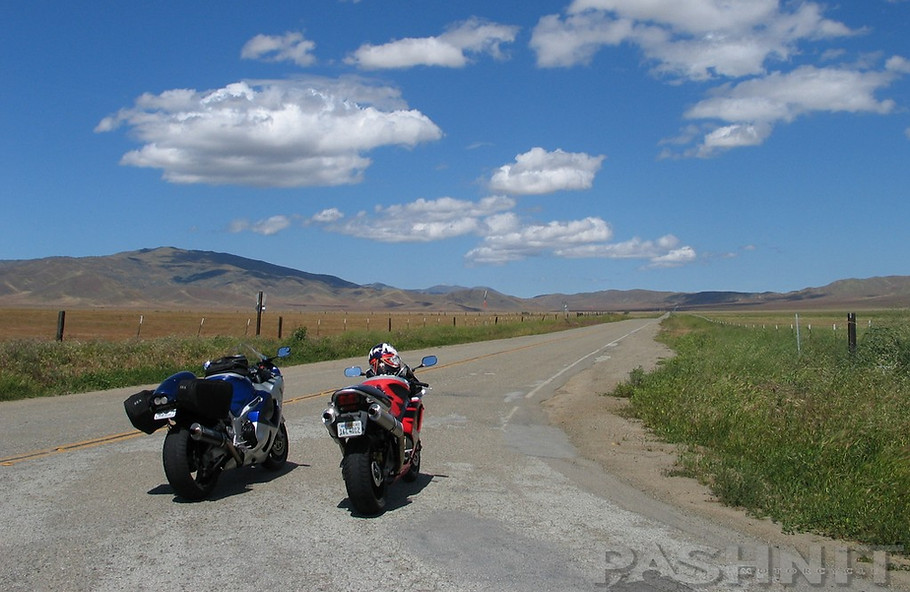
It's this long straight (looking back southward) where the very first lead photo below was shot, one my all-time favorites.

_JPG.jpg)
Surprise! New pavement from Interstate 5 to the Panoche Inn biker bar.
_JPG.jpg)
Mercey Hot Springs appears with a small grouping of RVs on the west side of the road. The main grouping of buildings around the spring is just behind the hillside and the gravel road curls around if you want to head on it to check it out, or are just curious. There are 9 campsites, 10 RV sites, 6 Cabins, 2 Airstreams and a group house, called Walkabout. There is a small hotel on site, but it’s currently not open to the public.
Dating back to 1912, the site was developed around the hot springs which are said to contain medicinal properties. Water emerges from the source at approximately 112°F. When it arrives at the outdoor hot tubs the water is between 102-106°F.
Renewed interest in the property has breathed new life into the hot springs and the current owners are working to renovate and update the property which is 'off the grid'. No phone or no electricity runs to Mercey Hot Springs. Power is supplied primarily via wind and solar power.
There are only 13 miles to Interstate 5 and Little Panoche Rd finishes up the experience with a meandering ride finally succumbing to a long straight through orchards where it finally reaches the highway. There is no gas when you reach the interstate, closest gas is one exit to the north at W Nees Ave. Closest food is likely Los Banos.
I felt as though I'd been introduced to one of those hidden gems that only motorcyclists hold dear. Deserted out of the way pathways of ethereal glee. The number of vehicles we'd seen on this weekend ride could be counted on one hand. With a finger or two to spare.
I pulled to the side of road pulling in the clutch and meeting up with Phil. I pointed to my belly. He nodded and kicked the RC51 into gear starting off once more heading to lunch, leaving Panoche Rd just the way we found it. Undisturbed.

_JPG.jpg)
New Pavement! Bumpy patched section has been repaved.
Getting There: There's only two main roads headed east off of Highway 25 - Panoche Rd & Los Gatos Rd so you can't get lost. From the Highway 25 side, ride south from Tres Pinos (gas) five miles to the intersection with Panoche Rd. Well-marked, there's also a small general store here servicing the Hwy 25 traffic & local ranchers. The east end is reached via a well-marked overpass for Shields Ave/Little Panoche Road from Interstate 5. Remember that Little Panoche Rd is also known as Highway J1, just depends on the map you're using. It's 48 miles between Hwy 25 & Interstate 5.

Panoche Rd / Little Panoche Rd - Photo Gallery


MORE INFO: Panoche Road
Maps
RIDE IT on a PASHNIT TOUR
48 Miles - LENGTH
Poor for the majority, Deceptively smooth at beginning/end- PAVEMENT
Tight, low pass, Smooth - CURVES
Hwy25/Paicines to Interstate 5 - CONNECTS
Tres Pinos, North of Panoche RdI-5 Junction - GAS
Hollister, Paicines - LODGING
Panoche Pass 2319 ft- PEAK ELEVATION
680 ft -Paicines ELEVATION
GPS LOCATION
- Paicines
- Panoche Inn
LISTED CONNECTING SIDEROADS:
Browns Valley Rd (dirt)
Yturiate Rd (dirt)
Jackass Grade (dirt)
New Idria Rd (paved- sort of)
Clear Creek Rd (dirt) requires permit & gate code
RELATED INFO:

