Northern California

Amador County, California
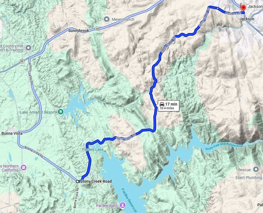
Stony Creek Rd
10 Miles - Length
Amador - COUNTY
Smooth two-lane- PAVEMENT
CA Foothills, sharp, sudden, banked, - CURVES
Sutter Creek, Valley Springs - GAS

Quick Ride: Quick blast of a quintessential Sierra Foothill road, curvaceous, fast, fun, and likely deserted. Build this one into the day's ride, or make it a leg in your route up through the Sierra Foothills.
Holy Grail Triad - Part II
Mentioned the phrase 'Holy Grail Triad' the other day to a fellow motorcyclist. Their eyebrow raised up a wee bit, and the obvious questions was posited. What is the Holy Grail Triad?
The response went something like this: How do you respond when someone says- What's a great motorcycle road? Surely the answer is different for everyone. Is it a long flat straight all to yourself like Central California’s Highway 25? Is it endless curves that stretch on for miles like Mosquito Ridge? Or how about mountain views to accompany your ride like Highway 108 over Sonora Pass.


My partiality has always been towards sustained speed. A what? Sustained speed in my little motorcycle mind is when you can actually ride the length of a curvy road and your speed varies very little.
So, imagine with me for a moment...
You're screaming up the hill, your left foot is getting a workout, your left hand is grabbing the clutch, the right fondles the brake - you shift a few times without the clutch by blipping the throttle.
Your boot is rubbing against the pavement, tossing the bike back and forth, manhandling it, working it. The sensation of the front tire biting the pavement transmits through the fork. You pick your line a long way off, set the gear, fixate on the braking point and listen to the spool of the motor as it builds power.
At the halfway mark in the turn, you roll the throttle and bite the rear pointing your chin towards the exit point.

You lose all sense of time.
All that matters is the next curve. Smooth. Grace. At the top of the hill, a straight appears and the bike beneath you rockets forward. Sensations of glee saturate from your toes to your fingertips, absorbed into your leathers, as if pulled through the very pores of the cowhide from the landscape around you.
An all-encompassing sense of motorcycle euphoria.

The roar of the exhaust is a sing-song melody, a cadence of ever onward.
The pressure of wind pushes against your chest and legs, the helmet against your cheeks. Relaxing now in straights, you watch the world go by as if you were standing still and it were actually the earth spinning beneath you. The next corner appears and you lean forward pointing shoulder and chin into the curve.
Stony Creek Road is like this. Lots of shifting, leaning, and high RPMs. It won't wear you down like longer rides such as Mosquito Ridge which will have you begging for a straight. These short little blasts are what motorcycle dreams are made of.

This sort of pace can be addicting. And the foothills are full of roads like this. Shoulders are few if any, that’s replaced with obligatory drop-offs. Plenty of blind corners but no switchbacks and no hairpins. These roads simply run up in elevation but this isn't the mountains- it's the foothills before the mountains.
No shoulders also mean no margin of error. Yes, there are many roads like this, however, Stony Creek Road will entice you, pull you in, and make you think you're better than you are.

The pavement is smooth, wide, and holds few surprise corners. The requisite bumps and assorted seasonal potholes to be avoided- other than that- the pavement is actually better than most surrounding roads. Something no map will reveal to you. This is a road for those of you who like to get out of the parking lot and ride. No other side roads and a sparse sprinkling of ranchettes and homesteads set off from the road ensure a rather deserted stretch of road for you to enjoy.
Always watch for any cars entering from their driveways. These people may not be used to your bike coming out of nowhere. The ride ends up hitting Jackson at Highway 49. From here you can link up with numerous other rides.
(1) Sutter Ione Rd, (2) Stony Creek Rd, & (3) Pool Station Rd all have a lot in common. Maybe a factor of the elevation: they twist, they turn, rising and falling providing a high-speed intense ride when ridden uphill. Keep in mind, this ride can be very hot in summers and temps can easily be 90-100 degrees below the 3000 ft level.


What no switchbacks and no hairpins means is unlike nearby Big Hill Road above Columbia- the elevation rises slowly- lifting out of the Central Valley in a handful of rolling hills steadily getting higher. As if the road were painted in one single stroke pitching back and forth. Riding is like that sometimes.
The west end of Stony Creek Rd is somewhat hard to find and it’s best to ride uphill. Stony Creek Rd is overall short, a mere ten miles, and should be a leg in your journey. The northern leg of the Holy Grail Triad is Sutter-Ione Rd to the north and the southern leg is Pool Station Rd. Ride them together or simply take note they are an excellent alternative to Highway 49.
From Highway 26:
At Valley Springs, use Paloma Rd to Watertown to Campo Seco to Pardee Dam Rd. There are signs for the Reservoir and the pavement improves once on Sandretto Rd. Pardee Dam Rd circles around the north end of the lake and evolves into Stony Creek Rd. The dam at Pardee Reservoir was completed in 1929 with the intent to provide drinking water for the East Bay cities. It was the largest dam of its kind in July 1927 at 1337 feet long at the rim and 358 feet above the river. The road rides across the top of the dam, barely wide enough for vehicles, and is single lane with a stop light at either end. At the north side of the dam is a must-stop viewpoint to check out that overlooks Pardee Reservoir which spans 2257 acres.
From Highway 88:
From Highway 88 in Amador County, Ride Buena Vista Rd 5 miles south to Stony Creek Rd and to either Valley Road or Vista Road to the three blinks town of Buena Vista. There may be signs for Pardee Reservoir and the campground on the north side of the lake. At Buena Vista, both of these roads converge into Lancha Plan Road. A short distance later is Stony Creek Road. If these directions make no sense to you at all, don't feel bad, I've gotten lost in here numerous times. And I even had a map with me.

Stony Creek Rd - Photo Gallery


MORE INFO: Stony Creek Rd
RIDE IT on a PASHNIT TOUR
10 Miles - LENGTH
Very good, can be patched & bumpy - PAVEMENT
Quite a few - CURVES
Jackson, Valley Springs - GAS
Jackson - LODGING
1188 ft- PEAK ELEVATION
GPS LOCATION
38°20′56″N 120°46′27″W - Jackson
38°11′30″N 120°49′45″W - Valley Springs
LISTED CONNECTING SIDEROADS:
None
RELATED INFO
Pardee Reservoir
Jackson, California

Topo Maps