Montezuma Hills, Rio Vista, CA
- Tim Mayhew
- Jan 7, 2023
- 9 min read
Updated: Apr 28
Our motorcycle ride today begins along the ocean in Bodega Bay. This is a rather short ride headed inland across the state headed for the Sacramento River Delta. Been wanting to check out the Montezuma Hills and today is the day. Never heard of the Montezuma Hills? That makes two of us. I had to see it for myself.

Overnighting in Bodega Bay along the Pacific Ocean, we were treated to a lightning storm that lit up the sky most of the night with repeated flashes of light out over the ocean. But no rain at daybreak with the storm visible to the south along the ocean. I wanted to explore Bodega Bay. I had recently learned of the Bodega Bay Nuclear Power Plant, or rather the site that never became a nuclear power plant, and that sounded interesting.
Boats headed out of the harbor towards open ocean.

I found the Bodega Bay Nuclear Power Plant. Sort of.

A bit anti-climatic, the site of the Bodega Bay Nuclear Power Plant in present day is merely a small overgrown pond. The story though, is quite fascinating.

At the start of the 1950s, the 947 acres of Bodega Head, a thin peninsula that juts out into the ocean, was divided among three property owners. Late in the 1950s, PG&E acquired property from a local rancher to construct what was claimed to be the first nuclear power plant in the United States. Construction of the Atomic Park began in the early 1960s. During construction, PG&E was so confident of future permitting that it began to ready the site, including digging what was designed to be a 90-foot by 120-foot deep hole to house the reactor only to be thwarted by a grass-roots effort of concerned citizen's in 1964 that opposed a nuclear reactor being built here mere yards from the ocean.

Geologic studies at the site revealed an active fault line passed right through the deep pit, the discovery was made in the midst of construction. The proposed location of the Atomic Park was dangerously close to the San Andreas Fault, which was the deciding factor to halt construction. The fault line runs parallel to the coast and crosses Bodega Bay. During the 1906 San Francisco earthquake, nearby land moved as much as 15 feet; tremors are still common to this day. The discovery of the fault line beneath the proposed reactor site prevented the nuclear power plant from every being built.

The "hole" is constantly being replenished by the same fresh water spring that drew both Native people and early settlers to this location. Today, the site has been reclaimed by nature and is overgrown. A pond has taken over the 120 foot deep hole and any trace of a construction site has long since been reclaimed by nature.


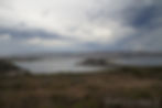
I rode out to the furthest point into the ocean to the Bodega Bay Trailhead and looked north. It was a view up the rugged Pacific coastline towards better weather.

Doran Campground across the entrance to the harbor. I'll have to check out Doran Beach another day.


Hole in the Head (Nuclear Power Plant site) on the left, Doran Campground on the spit of land at right. Bodega Bay in the background along the coast.
There was a parade of boats headed out of Bodega Bay into the open ocean at this early hour.

North of Bodega Bay is the Coleman Beach Overlook. We've stopped at this overlook many times along Highway 1 with over two decades of Pashnit Motorcycle Tour groups. The storm out over the ocean was headed inland. I could see flashes of lightning striking the ocean. The rain curtain was visible in the distance, but still no rain.

The peninsula of land sticking out into the ocean in the distance is Bodega Head where the Nuclear Power Plant site is found.

Looking north up the coast looked promising to escape the incoming weather, but I was headed inland. Highway 1 follows the edge of the ocean for 140 miles to Rockport until it finally curves inland across the Coast Range to avoid The Lost Coast.

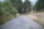
Coleman Valley Rd is a goaty backroad that climbs up into the Coast Range.

Coleman Valley Rd spans a mere 10 miles from the Highway 1 to Occidental.

Do you love the goat? I do. I do.
It may be single-lane narrow and bumpy, but...

The reward! Coleman Valley is best known for an amazing view of the Pacific Coastline.

The view from Coleman Valley Rd of the Pacific Ocean is its own reward. But, the rain curtain at left was chasing me inland.

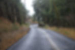
Coleman Valley Rd is short, it wiggles up to the top of the Coast Range.


Zero people, no traffic, nobody out here, a common theme with these rides.


The temperature changes very quickly. Temps will change over 30 degrees in a very short time span through this journey the further inland we ride. Still within sight of the ocean, and it was already time to re-layer. I watched the lightning storm over the ocean slowly come inland.
The rain curtains were chasing me away from the ocean.

Coleman Valley Rd is single lane with blind corners.


The one-room Ocean View School along Coleman Valley Rd dates to the 1920s.

Coleman Valley Rd is short, a mere 8 miles till it hits Joy Rd ,then another 2 miles down the other side into Occidental. To the south from here is Bodega and an easy reconnect with Highway 1 towards Tomales.

Coleman Valley Rd continues another 2 miles into Occidental and ends at The Bohemian Highway.


Coleman Valley Rd was littered with debris from the wind the night before.

Once the Coleman Valley Rd ends at Occidental, you can continue the eastward trek across the Coast Range on Graton Rd.

Graton Rd through the redwood forest was also covered in debris from the wind storm overnight.

Once I reached Graton, it was drizzling a wee bit, but not enough for the rain suit.


Along Graton Rd were endless fields of grape vines. I've recently gotten interested in grape vines and am building a vineyard in my front yard. I wanted to check out the construction of the grape rows & how the irrigation is set up.

Now the rain started up as a steady drizzle, but I gambled if I got away from the Coast Range, the rain would likely subside. Still not steady enough for the rain suit.

Love the house on the hill, call me Lord of the Manor.

Nearby is Chalk Hill Rd. The trick is to navigate around the edges of the cities without having to go through them plus stay off the main roads.


Chalk Hill Rd was quiet & deserted at this early hour.

Chalk Hill Estate West Vineyard

Not a fast road, but meandering hand-on-hip fun.


Chalk Hill Rd isn't anything to write home about, but it will keep you off the main roads, and works as a connector to get you over to the main road of Highway 128. It has little traffic and the pavement it fair. The scenery is perfect for a relaxed Sunday morning ride.

Maacama Creek Bridge, circa 1915

I wanted to stop by the Bale Grist Mill near Saint Helena, but it wasn't open, another excuse for a ride. But nearby was a road I wanted to check out.

On the last tour through here, we learned Old Howell Mountain Rd was closed, and it was part of my planned route. Bummer.

I wanted to see why it was closed.

Here's why it was part of the tour: it's a twisty ride up to Angwin and it narrows to single lane near the top as it reaches Deer Mountain Rd.

Old Howell Mountain Rd splits into Conn Valley Rd, but that's a dead end road.

The worst part was some segments had brand new repaving.

There was a road closed sign, but I just rode around it. I'm pretty sure those don't apply to motorcyclists.

Starting to see why the west side is closed. There was about six inches of pavement left, so I continued around the corner and on up the hill.

I bet the county has no plans to fix Old Howell Mountian Rd, ever. Too bad. It's a fun ride, steep, twisty, single lane, short.

I reached the end, and finally conceded. Fine! You win.

It was a good place to Taste the Rainbow and finish off my box of Skittles I'd been working on all weekend. As I merrily polished off the box, a bicyclist came up the road, picked his bike up and carried it over the tree branch blocking the road, then continued on his way. Oh, I see how it is.

Old Howell Mountain Rd parallels the main route, Deer Park Rd, up into Angwin, and the backside of the mountain was my consolation prize.

This is Howell Mountain Rd on the north side of Angwin. There's one more really goaty single lane (paved) backroad off this one, Ink Grade Rd, but I'll ride that another day.

It was damp which meant no shenanigan's, but twisty is twisty.

Do you ever get tired of looking at twisty roads? Not really. No rain on the north side, I was once more getting ahead of the rain clouds.

Lower Chiles Valley Rd

Lower Chiles Valley Rd is a quick shortcut over to Highway 128.
Goaty, mostly single lane, and short.


Finally reaching Highway 128, time to make a beeline to Collinsville, my destination. Never heard of it? No one has. It's in the middle of nowhere.

Turn south on the super-twisty Highway 121. Note that pavement, like butter.


I took the cover photo for the Pashnit.com homepage on this stretch of curves along Highway 121. Pure lean angle bliss.

Another turn south onto Wooden Valley Rd headed for Suisun City and then skipping south on Shiloh Rd. Huge windmills appear in the distance. Did you know there's a railroad museum out here? I didn't. The Western Railroad Museum is a few miles away. Another day, another excuse for a ride to check that out someday.

Shiloh Rd with a huge mountain taking shape in the distance, that's Mount Diablo.

A lot of railroad history out here (had no idea), note the power lines about the tracks. Electric trains used to run up and down these tracks. At one point, passenger rail traffic passed near Collinsville before bridges were built across the Sacramento River. The steam engine would unbuckle from the passenger cars at present-day Mallard Island west of Pittsburg and then loaded onto barges and floated across the Sacramento River to Chipps Island. The process was time-consuming and could require several trips across the river to manually transfer all the railcars from land to barge to land. The rail line then headed northeast towards Sacramento. Most of these tracks have long-since been pulled up, except the original tracks that are south of the current Western Railroad Museum.

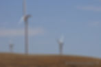
We're now approaching the Montezuma Hills, which are covered in windmills.


The Montezuma Hills are primarily a rural region used for sheep grazing and growing hay.

Birds Landing was a ghost town.

I rode to the end of this dead end just to see what was at the end. It ended at the edge of Suisun Bay. C. J. Collins settled here in 1859 and named it after himself. In present day, a few houses remain.

I made it to the Montezuma Hills.

Never heard of the Montezuma Hills? No one has. This region of low rolling hills borders the southern edge of the Sacramento River Delta west of Rio Vista. The term Montezuma dates to the name of the Aztec ruler at the time that Cortez invaded Mexico. The name Montezuma was a common US place name during that time. Plans for a city were laid out in the Montezuma Hills as early as the 1850s, but the grand plans for a city never grew past the original cabin.
Atop the present-day Montezuma Hills, the 6800-acre Shiloh Wind Power Plant was built in the early 2000s with numerous windmills that tower 260 feet high, taking advantage of the Delta Breeze. The Delta Breeze is a natural phenomenon where cool ocean air inflows from the Pacific up a natural corridor along the surface of the low-lying delta towards the Sierra Nevada. The city of Sacramento is in the direct path of these inflows, and the Delta Breeze can cool the air significantly in the heat of summer.

The Shiloh Wind Power Plant spans 6800 acres & uses the Delta Breeze to generate enough power to supply 74,000 homes.

Did you also know that beneath the Montezuma Hills is a massive natural gas field? Underneath the hills outside Rio Vista is the largest natural gas field in California, and the fifteen largest in the United States. These hills around Rio Vista have produced over 3.6 trillion cubic feet of gas in their lifetime and are said to contain an estimated reserve of another 330 billion cubic feet of natural gas.


Dry in late summer, best to ride this in early spring when these hills are glowing green from winter rains.


The turbine rotors have a diameter of 253 ft. There are also gravel roads that wind through the hills more suited for dual sport bikes.

Montezuma Hills Rd flows into Rio Vista along the south edge of the Sacramento River Delta.

Best time of year for this ride through the Montezuma Hills is in winter and early spring. The hills are brilliant green, and the Sacramento River Delta is always flowing with spring snowmelt from the nearby Sierra Nevada Range.

Back at home base, it was time for new shoes.

Learn more about multi-day tours with Pashnit Motorcycle Tours or discover many more curvy roads on California Motorcycle Roads.